NOTES ABOUT SOUTHERN CALIFORNIA WEATHER & CLIMATE
© 2000-2024 Gary Valle'. All Rights Reserved.
|
NOTES ABOUT SOUTHERN CALIFORNIA WEATHER & CLIMATE © 2000-2024 Gary Valle'. All Rights Reserved. |
IMPORTANT!! The
information presented on this web site may include errors of transcription,
interpretation, and other errors. The information may be out of date or
inaccurate. Please refer to the NATIONAL WEATHER SERVICE FORECAST OFFICE
LOS ANGELES or your local weather service office for official
forecasts and warnings. |
Previous Month - Index - Next Month
|
Waiting For Rain. NOAA
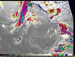
Updates Winter Outlook. If we were in Phoenix, the forecast for the next couple of days would be more straightforward. An upper level low system that has been spinning off the Baja coast is forecast to draw subtropical moisture into northern Mexico and Arizona, and according to the the HPC, produce as much as 4.5 inches of rain in areas of the desert Southwest between now and Sunday afternoon. |
||||||||||||
Upper level forecasts show a complex scenario evolving as the cut-off upper low merges with a short wave embedded in a broadening trough over the west coast. This morning's 3-day precipitation forecast from the HPC showed no precipitation in our area, but the 09z SREF, 12z NAM, and 12z GFS all suggested the likelihood of at least a little rain in Los Angeles county, and the midday update of the HPC forecast now includes some green here. With a tweak here or there, the amount of rain could be more significant. Precipitation probabilities for the Los Angeles area derived from the 09z SREF indicate about a 70% probability of at least 0.01 inch of rain, a 50% probability of at least 0.10 inch of rain, and about a 30% probability of at least 0.25 inch of rain for the 24 hour period ending Saturday morning. Over this same period, a BUFKIT analysis of 12z NAM data generates about 0.15 inch at Van Nuys, while the 12z GFS generates only about 0.03 inch. An experimental ERSL/PSD ensemble based Analog Probability Precipitation Forecast (reference) appears to side with the GFS. We'll see! NOAA released its updated Winter Outlook November 15 and the NDJ outlook for Southern California precipitation continues to be bleak, with a >50% chance of below normal precipitation from Monterey to the Mexican border. A look at the corresponding POE curve for coastal Southern California is not reassuring, indicating the following probabilities:
More information
concerning Southern California weather can be found using our WEATHER
LINKS page. |
|||||||||||||
or Press your Browser's BACK button.