NOTES ABOUT SOUTHERN CALIFORNIA WEATHER & CLIMATE
© 2000-2024 Gary Valle'. All Rights Reserved.
|
NOTES ABOUT SOUTHERN CALIFORNIA WEATHER & CLIMATE © 2000-2024 Gary Valle'. All Rights Reserved. |
IMPORTANT!! The
information presented on this web site may include errors of transcription,
interpretation, and other errors. The information may be out of date or
inaccurate. Please refer to the NATIONAL WEATHER SERVICE FORECAST OFFICE
LOS ANGELES or your local weather service office for official
forecasts and warnings. |
Previous Month - Index - Next Month
|
NOAA Releases Updated Winter
Outlook. Chance of Showers Monday. Warm November. El Niño
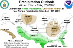
Continues to Strengthen. NOAA released its final Winter Outlook for the 2006-2007 U.S. Winter season on November 16. The revised outlook indicates a somewhat better chance of a wetter than normal Winter in Southern California, than the outlook issued October 19. The outlook takes into account expected impacts resulting from the developing El Niño, and other factors. |
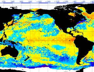
The computer models have been forecasting a chance of showers for Southern California Monday. Today's 09z SREF puts the odds of more than 0.01 inch of rain in the Los Angeles area for the 24 hr. period ending Monday at 4:00 p.m. PST at about 50%, and the odds for more than 0.1 inch at about 30%. In the shorter term, gale force offshore winds may generate a coastal eddy circulation tonight. This could pull in the marine layer and deepen it enough to produce some low clouds, fog and drizzle in the Los Angeles area overnight tonight and tomorrow morning. The situation is complicated by a weak upper level disturbance that is forecast to move through the area early tomorrow morning. This could disrupt the eddy circulation, or increase the chance of precipitation, or help mix out the marine layer. We'll see! It's been warm this November. Downtown Los Angeles (USC) set new high temperature records for the date on November 6, November 7 and November 20. The average high temperature the first 22 days of November was 81.4°F, which is about 7°F above normal. The 2006-2007 El Niño has continued to strengthen. Another strong westerly windburst has occurred, and TAO/TRITON 5 day data shows a large area of Pacific equatorial SST anomalies exceeding 1.5°C, and depth averaged temperatures exceeding 2.0°C. This TAO/TRITON section plot of depth averaged temperatures shows the evolution of the upper ocean temperature anomalies. Dr. Klaus Wolter's Multivariate ENSO Index (MEI) for September/October increased from 0.892 to 1.03, and the expected increase in the MEI for October/November will likely move the MEI above the strong El Niño threshold, as defined by the index, but well below that observed in the very strong 1997-1998 event, when the MEI peaked at 2.85. More information concerning Southern
California weather can be found using our WEATHER
LINKS page. |
|
|
November Temperatures Soar.
El Niño Continues to Strengthen. Slight Chance of a Shower? Woodland Hills' (Pierce College) high temperature of 101°F on Tuesday was the highest November temperature ever recorded there. Downtown Los Angeles' 97°F set a new record for the date, and it was the highest temperature ever recorded by the station so late in the season. Many other stations around the area also set new record highs. |
Dr. Klaus Wolter's Multivariate ENSO Index (MEI) for September/October increased from 0.892 to 1.03. This increase moves the MEI to just below the strong El Niño threshold, as defined by the index. This is the highest value of the MEI for August/September and September/October since the very strong 1997-1998 event, when the MEI peaked at 2.85. Today's 12z GFS and 18z NAM suggest a slight chance of a shower Saturday afternoon into Sunday. The GFS was a little stronger and faster with the system than the NAM. We'll see! Update 11/13/06 10:00 A.M. Saturday's system produced measurable rain in San Luis Obispo and Santa Barbara counties, and 0.01 inch or so was measured at a couple of stations south of Los Angeles county. Some sprinkles reached the ground in the Los Angeles area, but I didn't find any stations with measurable rain. Another wrinkle embedded in the strong northwesterly flow aloft will pass through central California today and tonight. The best chance of precipitation should be north of Pt. Conception, with an emphasis on the central Sierra. More information concerning Southern
California weather can be found using our WEATHER
LINKS page. |
|
or Press your Browser's BACK button.