NOTES ABOUT SOUTHERN CALIFORNIA WEATHER & CLIMATE
© 2000-2024 Gary Valle'. All Rights Reserved.
|
NOTES ABOUT SOUTHERN CALIFORNIA WEATHER & CLIMATE © 2000-2024 Gary Valle'. All Rights Reserved. |
IMPORTANT!! The
information presented on this web site may include errors of transcription,
interpretation, and other errors. The information may be out of date or
inaccurate. Please refer to the NATIONAL WEATHER SERVICE FORECAST OFFICE
LOS ANGELES or your local weather service office for official
forecasts and warnings. |
Previous Month - Index - Next Month
|
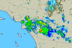
Cold Upper Low Generates
Extreme Weather in Southland. More Wet Weather Possible Today
and Tomorrow. The unseasonably energetic upper level low that replaced our unseasonably strong high has resulted in dramatic weather in Southern California, including heavy rain, hail, thunderstorms, lightning, and even a pair of tornadoes near March Air Force base. This UCAR regional radar image from yesterday at 5:00 p.m. shows the intense cell that likely spawned the tornadoes. |
In Los Angeles County, very heavy rain was recorded in the San Gabriel Valley. According to a NWS Public Information Statement, as of 7:00 p.m. yesterday, 2.29" was recorded at Santa Fe Dam, 1.51" at Whitter Narrows, and 1.42" at the San Gabriel River at Valley. Yesterday, Downtown Los Angeles (USC) recorded 0.05 inch of rain, bringing the water year total to 13.47 inches. Intellicast radar shows showers continuing in Southern California this morning. The upper level low is forecast to remain over Southern California into Sunday, and BUFKIT analysis of 12z NAM data for several Southern California stations (VNY, LAX, ONT) suggest on and off rain showers may occur through Sunday morning. As long as the cut-off upper low remains over the area there is also the possibility of an isolated heavy shower or thunderstorm developing. We'll see! Update Sunday, May 26, 2008. Here is an archived copy of a NWS Public Information Statement with rainfall totals for this event through 6:00 p.m. Saturday. More information concerning Southern
California weather can be found using our WEATHER
LINKS page. |
|
|
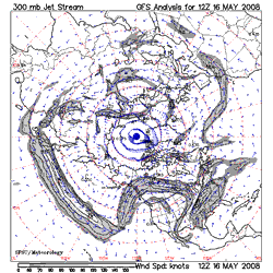
Strong Pacific Jetstream
Pumps Up West Coast Ridge & Temperatures. Chance of a
Shower Next Weekend? An unseasonably strong and extended Pacific jetstream has resulted in a very high amplitude high pressure ridge over the West Coast with record and near record temperatures seen from Seattle to San Diego. |
Yesterday, Woodland Hills set a new high temperature record for the date of 101°F. Record high temperatures were also recorded at Ojai, Sandberg, Santa Ana, El Cajon, Red Bluff, Redding, Sacramento, Stockton, Modesto, San Jose, Eureka and several other stations in California. Triple digit highs were recorded across much of the interior of the state. It's hot again today, and will be hot again tomorrow, but the GFS, ECMWF and other guidance is suggesting that as the extended Pacific jet collapses, the west coast ridge will retrograde off the coast and be replaced by a trough by Memorial Day Weekend. This would result in cooler weather in California, and even the possibility of showers in some areas, such as the Sierra and our local mountains. We'll see! More information concerning Southern
California weather can be found using our WEATHER
LINKS page. |
|
|
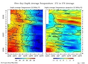
La Niña Fades as Rain
Season Nears End. In it's April 30 ENSO Wrap-Up, the Australian Bureau of Meteorology characterizes Pacific climate patterns as being generally neutral, "with the majority of indicators returning to near-normal levels." The April 28 ENSO Update from the CPC suggests that La Niña will continue through May-July 2008, but many of the factors discussed indicate general weakening of the cold ENSO episode. |
We've had only a smattering of rain at Downtown Los Angeles since 0.46 inch was recorded back on February 24. A miniscule 0.01 inch was recorded on March 15, and 0.04 inch on April 2. These NOAA/NWS AHPS Precipitation Analyses map the 60 day Departure from Normal Precipitation and 60 day Percent of Normal Precipitation for the southwestern U.S., as of April 30, 2008. As of May 1, the water year rainfall total for Downtown Los Angeles (USC) stands at 13.42 inches. This is 90% of the 1921-2006 average of 14.87 inches. According to the 1921-2006 dataset, the average amount of precipitation in May and June has been 0.3 inch and 0.1 inch, respectively. Today's NWS 6-10 Day and 8-14 Day Precipitation Outlooks for Southern California continues to indicate Normal precipitation. We'll see! More information concerning Southern
California weather can be found using our WEATHER
LINKS page. |
|
or Press your Browser's BACK button.