NOTES ABOUT SOUTHERN CALIFORNIA WEATHER & CLIMATE
© 2000-2024 Gary Valle'. All Rights Reserved.
|
NOTES ABOUT SOUTHERN CALIFORNIA WEATHER & CLIMATE © 2000-2024 Gary Valle'. All Rights Reserved. |
IMPORTANT!! The
information presented on this web site may include errors of transcription,
interpretation, and other errors. The information may be out of date or
inaccurate. Please refer to the NATIONAL WEATHER SERVICE FORECAST OFFICE
LOS ANGELES or your local weather service office for official
forecasts and warnings. |
Previous Month - Index - Next Month
|
Rainfall Record Set in 1921
Broken. According to a NWS preliminary Record Event Report, released at 12:50 this afternoon, Downtown Los Angeles (USC) has recorded 0.67 inches of rain so far today, surpassing a record of 0.33 inches set in 1921. As of 11:00 A.M., the NWS reports that the total rainfall recorded at Los Angeles (USC) for the storm has been 0.84 inches. |
Rainfall totals around the area have generally ranged from about 0.5 inches to over 2.0 inches. According to precipitation data from the California-Nevada River River Forecast Center, as of noon, Culver City had recorded 0.52 inches, Brown's Canyon 1.28 inches, Circle X Ranch 2.03 inches and Malibu 2.55 inches. Rain this late in May in Los Angeles is unusual. A Precipitation Probability plot from the Western Regional Climate Center, based on data from 1914-2005, indicates that the probability of more than 0.50 inch of precipitation in Los Angeles on a day in late May is almost nil. But it does happen -- according to the NWS, most recently on May 28, 1990, when 1.14 inches was recorded. The late May storm in 1921 was extremely unusual. According to NWS and NCDC data, 2.2 inches of rain was recorded from May 20-22, 1921, and each of the three days set a rainfall record that has stood until the May 22 record was broken today. At the moment, it looks like a return to more seasonable May weather, with no precipitation forecast for at least the next several days. We'll see! More information concerning Southern
California weather can be found using our WEATHER
LINKS page. |
|
|
Summer Monsoon, to be Followed
by Winter Rain? So far this year we've had eighty degree temps in February, foothill snow in March, and record rain in April; so why not a Summer monsoon pattern in May, followed by an unseasonably strong Winter-like Pacific storm system? |
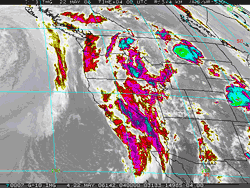
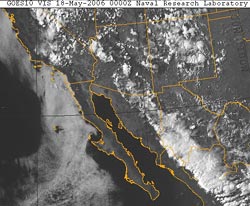
Yesterday, monsoon-like southeasterly flow resulted in thunderstorms over areas of the southwest and in the Sierra, and more thunderstorms may develop today, particularly over the mountains, and high desert. An upper level low associated with a weakening storm system that has been spinning out in the eastern Pacific is forecast to merge with a unseasonably strong trough digging down the west coast over the next 48 hours, and form a closed upper level low off the California coast. Computer models show the system being driven by a 130-150 kt. jet on the back side of the trough, with unusually strong dynamics for the season. A shortwave impulse rotating trough the base of the low into the west coast is expected to produce unsettled weather and a chance of showers over much of California Friday into Saturday, with the best chance of precipitation in the northern two-thirds of the state. Things could get interesting on Sunday as the low moves closer to the coast. Both the 12z GFS and the 12z ETA show a front developing and moving through the Los Angeles area Sunday. The GFS incarnation of the front is quite a bit stronger, generating 1.23 inch of rain at Los Angeles. Keeping in mind the time of year, and the lead time of the forecast, we'll see! Yesterday's NWS Climate Summary for Downtown Los Angeles (USC) indicates 12.34 inches of rain has been recorded since July 1, 2005, which is 2.6 inches below normal. More information concerning Southern
California weather can be found using our WEATHER
LINKS page. |
|