
NOTES ABOUT SOUTHERN CALIFORNIA WEATHER & CLIMATE
© 2000-2024 Gary Valle'. All Rights Reserved.
|
NOTES ABOUT SOUTHERN CALIFORNIA WEATHER & CLIMATE © 2000-2024 Gary Valle'. All Rights Reserved. |
IMPORTANT!! The
information presented on this web site may include errors of transcription,
interpretation, and other errors. The information may be out of date or
inaccurate. Please refer to the NATIONAL WEATHER SERVICE FORECAST OFFICE
LOS ANGELES or your local weather service office for official
forecasts and warnings. |
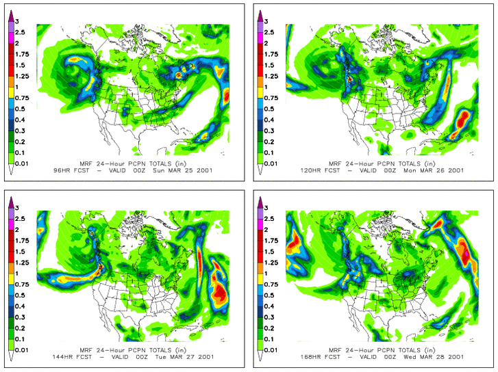 CDC MRF Forecast 03/21/01 00z |
Weathernotes for Wednesday, March 21, 2001Sometimes the model magic works, and sometimes it doesn't. Last Saturday models were suggesting the possibility of rain over much of California this coming weekend. The forecast system is out in the Pacific, but is expected to move into the Pacific Northwest. |
|
It's remarkable that models do as well as they do. Weather is chaotic. A seemingly insignificant event can dramatically change a predicted outcome. Even if the computer weather models were perfect they would not be able to predict the weather with 100% accuracy. There is an upper limit to performance because, in effect, more than one outcome is possible up until the instant in time that a particular outcome occurs. The further out the forecast the more possibilities they are and the less likely that any particular outcome will occur. Currently, models forecast the upper air pattern 5 days in advance with a anomaly correlation of about 0.8. Eight days out this falls to 0.5. There are variations in performance from model to model, and season to season. Overall, model performance is improving. Yesterday's CPC/NCEP Outlooks depicted "Below Normal" precipitation for the 6-10 day period and "Normal" for the 8-14 day period for Southern California. Forecast confidence was 3 on a scale of 1-5. We'll see! More information concerning Southern California weather can be found using our WEATHER LINKS page. |
|
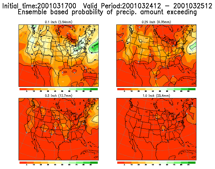
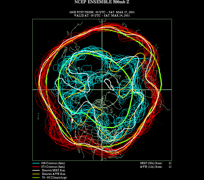 Ensemble spaghetti Plots for 03/24/01 00z |
Weathernotes for Saturday, March 17, 2001Copious rain has ensured a green St. Patrick's Day for Southern California, with clear dry weather expected over most of the area the next few days. However... If current medium range forecasts verify, next weekend would be at best blustery, and at worst, quite wet. At the moment, the ensemble precipitation probability forecast for Saturday suggests a chance of rain over most of California, and the MRF brings a pretty good shot of rain into Southern California. Nearly all ensemble members indicate some sort of trough off the west coast by the end of the week. |
|
Yesterday's CPC/NCEP Outlooks were back to depicting "Above Average" precipitation for the 6-10 day period and "Above Average" for the 8-14 day period for Southern California, but forecast confidence was 2 on a scale of 1-5. We'll see! More information concerning Southern California weather can be found using our WEATHER LINKS page. |
|
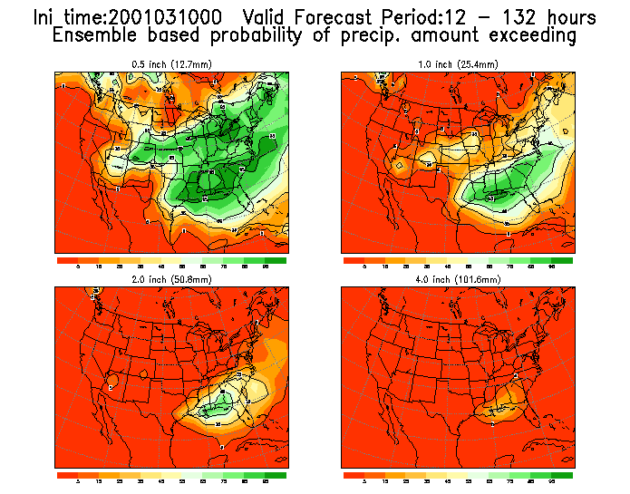 Ensemble Precipitation Probability Days 1-5 03/10/01 00z |
Weathernotes for Saturday, March 10, 2001Following several weeks of wet weather it appears that Southern California may be returning to a more seasonable regime. Downtown Los Angeles (USC) recorded only 1.20 inches of rain from July 1, 2000 to the end of the year. Since New Years the station has recorded 15.63 inches. Nearly 9 inches above the climatic mean. |
|
Surprisingly, yesterday's CPC/NCEP Outlooks were back to depicting "Above Average" precipitation for the 6-10 day period and "Above Average" for the 8-14 day period for Southern California. Today's ensembles for the 6-10 period would seem to support "Normal" precipitation over most of Southern California. The Week 2 forecast looks a little wetter. We'll see! More information concerning Southern California weather can be found using our WEATHER LINKS page. |
|
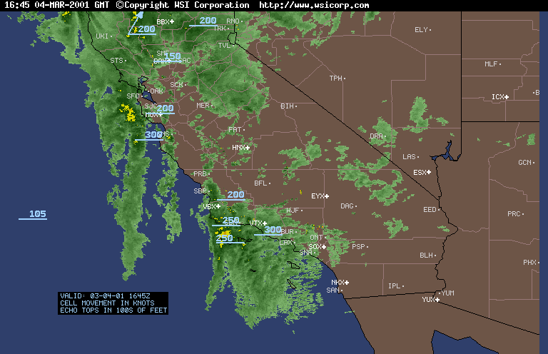
 Intellicast Radar Summary 03/04/01 1645z |
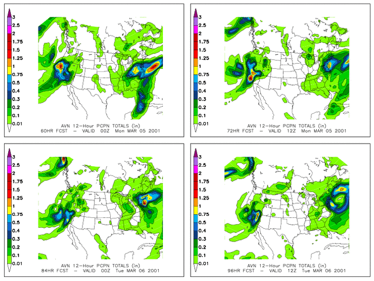
Weathernotes for Monday, March 5, 2001Potent double vortex system resulting in heavy Sierra snowfall and heavy rain in San Luis Opisbo, Santa Barbara, and Ventura counties. Forty-eight hour rainfall amounts of 3.0 to 5.0 inches common, with much higher amounts at some stations. San Marcos Pass recorded 10.04 inches for the 48 hour period ending at 7:00 this morning. |
|
Snow levels have risen with rain falling on earlier snows, resulting in additional run-off. Dramatic increases in run-off can be seen in levels recorded on automated gages such as the Cuyama R blw Buckhorn Cyn, Santa Cruz Cr nr Santa Ynez, and Piru Creek above Pyramid Lake. The AVN shows these vortices combining and moving into Southern California tomorrow. Heavy rainfall is expected later this afternoon and tonight with 24 hour QPFs ranging from 2.2 inches downtown to over 6.0 inches in the mountains. Yesterday's CPC/NCEP Outlooks were back to depicting "Above Average" precipitation for the 6-10 day period and "Above Average" for the 8-14 day period for Southern California, and today's ensembles suggest the wet pattern may continue for Southern California. More information concerning Southern California weather can be found using our WEATHER LINKS page. |
|
 Intellicast Radar Summary 03/04/01 1645z |
Weathernotes for Sunday, March 4, 2001The Intellicast Radar Summary shows plenty of moisture around Southern California this morning, but not much rain... yet. The leading low veered well to the north, taking last nights forecasted precipitation with it. There was rain in Southern California; it was just limited to the Central Coast and Santa Barbara County. Rain is still in the forecast. The initial front has stalled offshore, but RAMDIS is starting to show some eastward movement. HPC still shows copious amounts of rain over the next two to three days. |
|
For the first time in quite a while yesterday's CPC/NCEP Outlooks depict "Normal" precipitation for the 6-10 day period and "Normal" for the 8-14 day period for Southern California instead of "Above Average." More information concerning Southern California weather can be found using our WEATHER LINKS page. |
|
 12z AVN 03/02/01 |
Weathernotes for Friday, March 2, 2001The computer models have had a tough time forecasting the weather for this weekend and early next week. They have flip-flopped from big storm; to weak storm; to practically no storm at all, and back again. Today they seem to be converging on the idea that Southern California is going to get drenched, again. Today a weak system is resulting in rain in Central California and may result in some showers in northern areas of Southern California, and perhaps a sprinkle or two further south. |
|
This weekend all eyes turn to the Pacific as another wet Pacific storm approaches the coast. Like last weekend, the timing of the onset of precipitation is difficult to predict and the short term models differ somewhat in their forecasts. At the moment it looks like precipitation should hold off until the late Saturday afternoon or evening, but overrunning moisture ahead of the system could result in light rain earlier than expected. In any case rain is expected by late Saturday, with the main event Sunday into Monday, and periods of rain continuing through the week. Yesterday's CPC/NCEP Outlooks continued to depict "Above Average" precipitation for the 6-10 day period and "Above Average" for the 8-14 day period for Southern California, and today's ensembles suggest the wet pattern will continue for much of California. More information concerning Southern California weather can be found using our WEATHER LINKS page. |
|
