NOTES ABOUT SOUTHERN CALIFORNIA WEATHER & CLIMATE
© 2000-2024 Gary Valle'. All Rights Reserved.
|
NOTES ABOUT SOUTHERN CALIFORNIA WEATHER & CLIMATE © 2000-2024 Gary Valle'. All Rights Reserved. |
IMPORTANT!! The
information presented on this web site may include errors of transcription,
interpretation, and other errors. The information may be out of date or
inaccurate. Please refer to the NATIONAL WEATHER SERVICE FORECAST OFFICE
LOS ANGELES or your local weather service office for official
forecasts and warnings. |
Previous Month - Index - Next
|
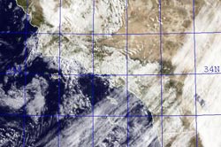
MEI Continues to Rise.
Santa Barbara Sets Rainfall Record. More Rain in Los Angeles. Instability and moisture associated with a very late season upper level low produced more rain in Southern California Friday, setting a record for June rainfall at Santa Barbara Airport. |
Downtown Los Angeles (USC) recorded a total of 0.13 inch of rain Friday. The rainfall increased the water year precipitation total for Los Angeles to 9.08 inches, which is 6.05 inches below normal. Santa Barbara Airport recorded 0.51 inch, setting not only a new record for the date, but for any day in June, as well as for the total amount of rain in June. Here's an archived copy of a NWS Public Information Statement with some preliminary rainfall totals from around the area as of 5:00 p.m. Friday. The April-May Multivariate ENSO Index (MEI) value (released today) has increased by 0.54 to +0.34. As discussed by MEI originator, Klaus Wolter, the 3-month rise of the MEI since January-February is the 4th highest on record for this time of year, exceeded last by the strong Niño of 1997. According to Dr. Wolter, if next month's MEI rank is at least the same as this month (37th), "it would be unprecedented for it to drop below that high-neutral ENSO-phase range by the end of 2009, virtually excluding a return to La Niña, based on the MEI record since 1950." We'll see! More information concerning Southern
California weather can be found using our WEATHER
LINKS page. |
|
|
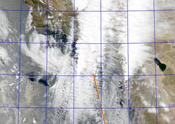
Late Season Thunderstorms
an El Nino Calling Card? Unusual weather for June. Not so much that there were thunderstorms, but that the thunderstorms were in part the result of an unseasonably strong jet embedded in the base of an offshore upper level low. |
It's a bit of a stretch, but an argument could be made that these storms were a calling card of an increasingly energetic atmosphere, and a developing El Niño. Downtown Los Angeles (USC) recorded a total of 0.02 inch of rain Wednesday. The rainfall increased the water year precipitation total for Los Angeles to 8.95 inches, which is 6.16 inches below normal. It's not often that a trace of rainfall sets a record, but that was the case at Camarillo Airport and Palmdale, which had not previously recorded precipitation on June 3. The 0.03 inches recorded at Sandberg was also a record. Here's a CNRFC graphic with some 24 hour rainfall totals in Los Angeles County. Several factors point to an increased probability of El Niño conditions developing over the next few months. Among them, Equatorial Pacific SSTs have increased, and the subsurface heat content is the highest it's been since the El Niño of 2006-07. But as the short-lived 2006-07 El Niño event demonstrates, an El Niño is more than just warm Pacific equatorial SSTs. Through complex forcing and feedback mechanisms, the atmosphere and oceans have to cooperate on a global scale. Generally speaking the momentum of the atmosphere increases when there is an El Niño, and decreases during a La Nina. And it looks like the atmospheric momentum may be increasing. Orbits of the Global Wind Oscillation (GWO), a measure of atmospheric momentum, have been shifting upward, in the direction of more energetic values usually associated with an El Niño. However, an El Niño is not a done deal. The climate system is just leaning in that direction. As climate scientist Klaus Wolter has previously pointed out, in a similar situation in 1973-1975, the climate fell back into a La Niña for another year. But at this point it appears we may be diverging from that analog case. (See June 6 Weathernotes.) We'll see! Update 06/05/09. Unseasonably strong 110+ kt jet overhead as upper low center moves onshore in Central California. At 7:15 this morning, Intellicast composite radar showed most of the shower activity occurring to the north of Los Angeles, but there has been scattered showers in the Los Angeles area as well, with measurable rain recorded at a number of stations. Here's an archived copy of a NWS Public Information Statement with some preliminary rainfall totals as of 5:00 p.m. More information concerning Southern
California weather can be found using our WEATHER
LINKS page. |
|
or Press your Browser's BACK button.