NOTES ABOUT SOUTHERN CALIFORNIA WEATHER & CLIMATE
© 2000-2024 Gary Valle'. All Rights Reserved.
|
NOTES ABOUT SOUTHERN CALIFORNIA WEATHER & CLIMATE © 2000-2024 Gary Valle'. All Rights Reserved. |
IMPORTANT!! The
information presented on this web site may include errors of transcription,
interpretation, and other errors. The information may be out of date or
inaccurate. Please refer to the NATIONAL WEATHER SERVICE FORECAST OFFICE
LOS ANGELES or your local weather service office for official
forecasts and warnings. |
Previous Month - Index - Next Month
|
Heat Wave Continues. New El
Niño Developing? However you want to look at it, it has been a hot summer. Based on (preliminary) NWS climate data for Burbank's Bob Hope Airport, June was hot, and the first 20 days of July have been even hotter. At times, higher than normal humidity has increased the discomfort. |
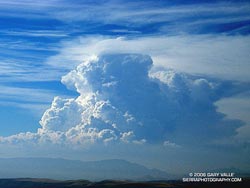
The NWS climate data for Bob Hope Airport shows that, on average, July has been nearly 6°F warmer than June, and about 6°F warmer than normal. In June the average high temperature at Burbank Airport was 87°F. So far this July it has averaged 94°F. When the temperature climbs above about 90°F, and the relative humidity is above about 35%, the effective or "feels like" temperature can be hotter than indicated by a thermometer. In the U.S. this "feels like" temperature is usually measured by a value called the Heat Index. For example, at 11:00 this morning the Beverly Hills RAWS recorded a temperature of 95°F, and a relative humidity of 43%. According to the NWS Heat Index chart, the Heat Index for that combination is 101°F -- nearly 6°F hotter. And, that calculation assumes shade and light wind. For full sun, the NWS notes that the Heat Index can be as much as 15°F higher! Maybe it won't make you feel any cooler, but next week take a moment to consider the ultrarunners that will be running in the 135 mile Kiehl's Badwater Ultramarathon. The race starts on Monday at Badwater, in Death Valley, 280' below sea level, and ends at Whitney Portal at 8360' in the Sierra. Some runners continue on to the summit of Mt. Whitney. To get an idea of the temperatures expected in Death Valley, see the NPS Death Valley National Park Morning Report (PDF). Is a new El Niño developing? It's too early to be sure, but this TAO/TRITON 5-day Depth Averaged Temperature Time-Longitude plot shows increased heat content in the equatorial Pacific. The Australia Bureau of Meteorology Summary of ENSO Forecasts reports that some ocean or coupled ocean/atmosphere forecast models are now forecasting warm conditions in the five month and eight month timeframes. We'll see! Update 07/22/06 8:00 P.M. Record setting heat in Southland with inland areas baking in Death Valley like temperatures. According to the NWS, Pierce College in Woodland Hills recorded a new all time high temperature for that station of 119°F; and many other Southern California locations recorded temperatures in excess of 110°F. More information concerning Southern
California weather can be found using our WEATHER
LINKS page. |
|
|
June Hot -- Rest of the Summer
Hotter? If you live away from the coast, you know it's been hot. But has it been warmer than last year? And what about the rest of the Summer, will the heat wave continue? |
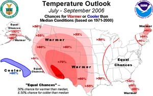
Sometimes it's hard to recall just what the weather was like a year ago, and somehow in the middle of a heat wave, it always seems hotter than it was the previous year. But this June, it really was hotter! Based on (preliminary) climate data for Burbank's Bob Hope Airport from the NWS, the average daily temperature was more than 7 °F higher this year than last. In June 2005, only 2 days recorded a high temperature of 90°F, or above, and the highest temperature recorded was only 91°F. This June, 13 days saw the thermometer hit 90°F or above, and the highest temp was 102°F. Will the above normal summer temperatures continue? NOAA released it's July-September 2006 Summer Outlook on June 20, and this suggests that if you live in Phoenix, the answer is probably yes. But in Southern California the signal is not so clear, with "equal chances" for warmer than normal, or cooler than normal, temperatures. Today's 6-10 day and 8-14 day Outlooks from the Climate Prediction Center forecast normal, and then above normal, temperatures for Southern California. We'll see! According to preliminary data in the NWS Climate Report issued July 1, 2006, Downtown Los Angeles (USC) recorded 13.19 inches for the 2005-2006 water year. This is 1.95 inches below normal, and far less than the 37.25 inches recorded last year. For Los Angeles precipitation data, the water year extends from July 1 to June 30. More information concerning Southern
California weather can be found using our WEATHER
LINKS page. |
|
or Press your Browser's BACK button.