
NOTES ABOUT SOUTHERN CALIFORNIA WEATHER & CLIMATE
© 2000-2024 Gary Valle'. All Rights Reserved.
|
NOTES ABOUT SOUTHERN CALIFORNIA WEATHER & CLIMATE © 2000-2024 Gary Valle'. All Rights Reserved. |
IMPORTANT!! The
information presented on this web site may include errors of transcription,
interpretation, and other errors. The information may be out of date or
inaccurate. Please refer to the NATIONAL WEATHER SERVICE FORECAST OFFICE
LOS ANGELES or your local weather service office for official
forecasts and warnings. |
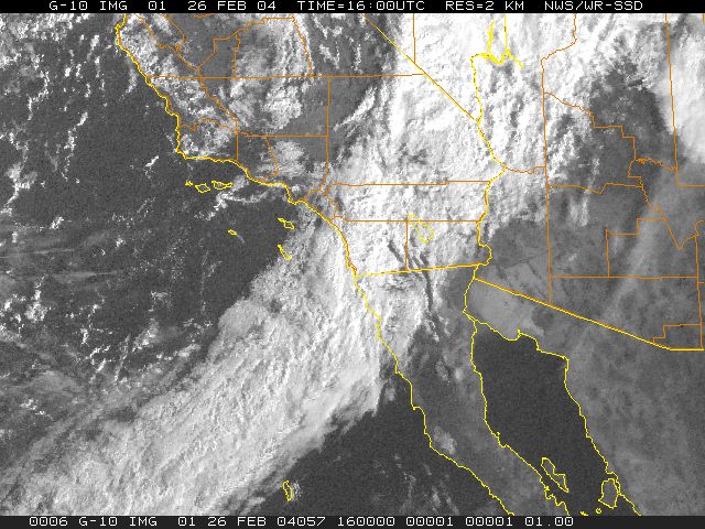 GOES-10 Visible Satellite Photo 1600z 8:00 am PST |
Weathernotes for Thursday, February 26, 2004Vigorous cold front associated with Pacific low and trough moving through San Diego and Riverside counties this morning, with rainfall rates ranging from about 0.1 to 0.3 inch/hour. Preliminary 24 hour rainfall totals in Ventura and Los Angeles county valleys ranged from about 2.0 to 3.5 inches, with 5.0 to 6.0 inches, or more in the mountains. This precipitation map from the Los Angeles County Dept. of Public Works shows county-wide 24 hr. rainfall totals as of about 8:00 this morning. |
Since July 1 downtown Los Angeles (USC) has received about 8 inches of rain, which is about 2.5 inches inches below normal. Ensemble forecasts show a upper ridge developing off the west coast, with systems working up an over the ridge back down into the southwest. The extended period outlooks, released yesterday, call for normal precipitation in the 6-10 day period, and below normal precipitation for the 8-14 day period. We'll see! More information concerning Southern California weather can be found using our WEATHER LINKS page. |
|
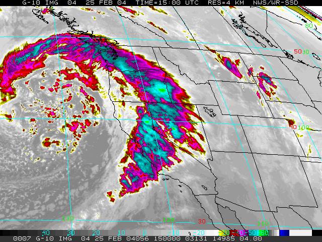 GOES-10 IR Satellite Photo 1500z 7:00 am PST |
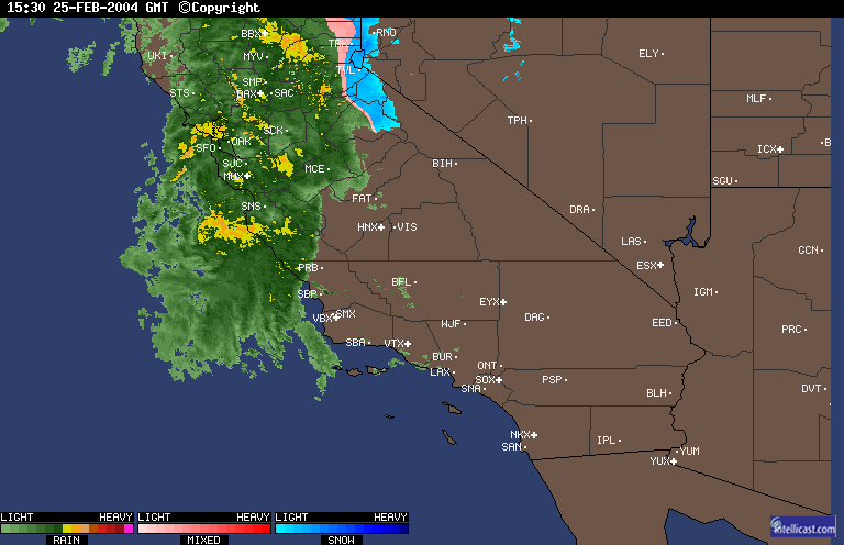
Weathernotes for Wednesday, February 25, 2004Potent Pacific system bearing down on the Southland, with computer models and other guidance consistent in forecasting a very wet, windy and potentially dangerous storm. Measurable rain has already been recorded as far south as San Marcos Pass in the Santa Barbara area this morning, and should move into the Los Angeles area later today. Heavy rain is expected overnight and unsettled, showery weather is forecast to last into Friday. |
A GOES-10 water vapor satellite photo from 7:30 am PST shows the structure and extent of the system. The sounding at Oakland this morning recorded a precipitable water value of 0.84 inch. A GOES-10 derived precipitable water value of about 1.3 inch was observed in an area of entrainment on the margin of the baroclinic zone. Intellicast composite radar from 7:30 am PST show moderate to heavy rain in the Monterey and San Francisco Bay area, with NWS gauges reporting rainfall rates generally ranging from about 0.1 to 0.3 inch/hour, but as high as about 0.5 inch/hour. This morning's (12z) 40 km ETA generates about 2.65 inches of rain at Los Angeles. However, with precipitable water values near one inch, very strong southerly inflow and vorticity advection, and possible jet enhancement, much higher amounts than this are possible; particularly in orographically favored mountain and foothill areas. Since July 1 downtown Los Angeles (USC) has received about 5.17 inches of rain, which is 5.11 inches below normal. The 6-10 day and 8-14 day outlooks call for below normal precipitation forecast, so yet another pattern change may be in the offing. We'll see! More information concerning Southern California weather can be found using our WEATHER LINKS page. |
|
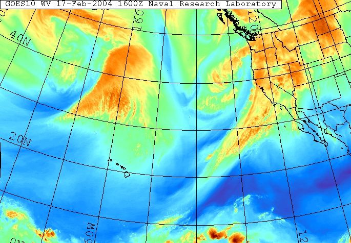 GOES-10 Water Vapor (NRL) 1600z 8:00 am PST |
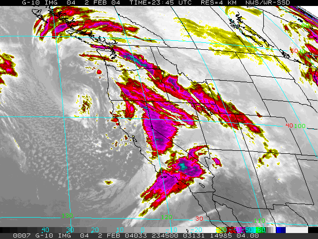
Weathernotes for Tuesday, February 17, 2004A pattern change is in the works for California with a transition to a split quasi-zonal flow and an active southern jet stream. GOES 10 water vapor imagery shows the first of a series of systems moving into California with a long fetch of moisture extending into the tropics. |
This system is forecast to produce heavy precipitation in Northern and Central California, but this morning's (12z) 40 km ETA and GFS generate only about 0.25 inch of rain at Los Angeles. However, with precipitable water values of about 0.75 inch, relatively strong southerly inflow and vorticity advection, localized higher amounts would seem probable; particularly in orographically favored mountain areas. Since July 1 downtown Los Angeles (USC) has received about 3.89 inches of rain, which is 5.34 inches below normal. The 6-10 day and 8-14 day outlooks appear promising with above normal precipitation forecast. We'll see! More information concerning Southern California weather can be found using our WEATHER LINKS page. |
|
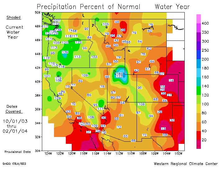
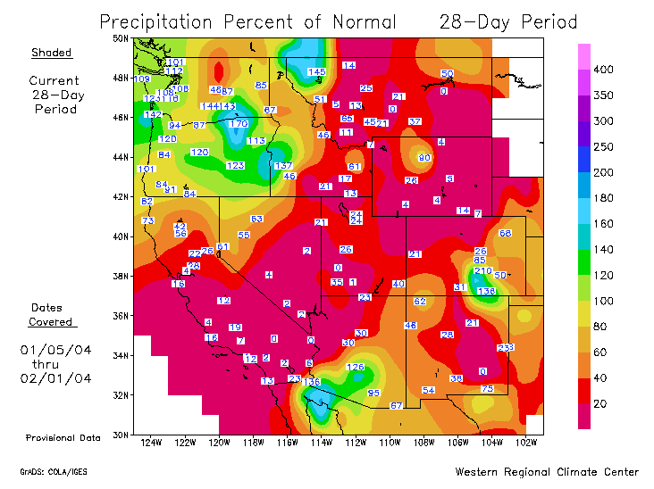 Precipitation Percent of Normal as of 02/01/04 |
Weathernotes for Tuesday, February 3, 2004A strong, but fast moving front associated with a digging trough produced rainfall amounts in the Los Angeles basin that generally ranged from about 0.50 to 1.0 inches, with up to about 2.0 inches in favored mountain areas. The rainfall brought the preliminary seasonal total at Los Angeles (USC) to 3.64 inches, which is 3.74 inches below normal for the date. |
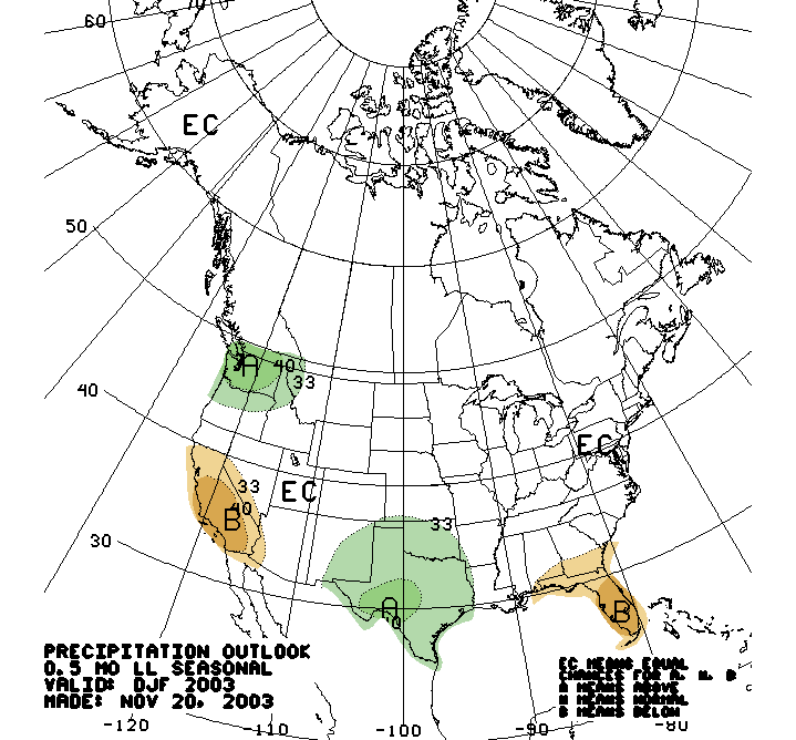
The rainfall is the first significant precipitation recorded at Los Angeles (USC) since January 2. A plot of the Precipitation Percent of Normal for the 28 days ending February 1, produced by the Western Regional Climatic Center, shows a large swath of below normal precipitation extending from California, through Nevada and Utah, to Wyoming and Montana. The plot of Precipitation Percent of Normal for the water year is not as dry, but the sub-normal precipitation in Southern California does appear to generally validate the long lead seasonal precipitation forecast issued November 20, 2003 for Dec-Jan-Feb. This indicated a precipitation probability anomaly of 40% below normal over a large area of Southern California. Following the passage of a system to our north on Friday, a high amplitude ridge is expected to rebuild. Yesterday's 6-10 day and 8-14 day outlooks continue to forecast below normal precipitation for Southern California. Depending on the orientation and amplitude of the ridge, there are still scenarios, such as a retrograding low, that could produce rain in Southern California. We'll see! More information concerning Southern California weather can be found using our WEATHER LINKS page. |
|
