NOTES ABOUT SOUTHERN CALIFORNIA WEATHER & CLIMATE
© 2000-2024 Gary Valle'. All Rights Reserved.
|
NOTES ABOUT SOUTHERN CALIFORNIA WEATHER & CLIMATE © 2000-2024 Gary Valle'. All Rights Reserved. |
IMPORTANT!! The
information presented on this web site may include errors of transcription,
interpretation, and other errors. The information may be out of date or
inaccurate. Please refer to the NATIONAL WEATHER SERVICE FORECAST OFFICE
LOS ANGELES or your local weather service office for official
forecasts and warnings. |
Previous Month - Index - Next Month
|
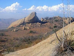
Heat Wave Expected to Continue. Los Angeles Pierce College in Woodland Hills recorded a high temperature of 109°F on Wednesday and Thursday, and so far today has reached a temperature of about 108°F. The hot weather is expected to continue through Labor Day, along with periods of higher than normal humidity. |
When the air temperature is above about 90°F, water vapor in the air can make the temperature feel hotter than indicated by a thermometer. In the U.S. this "feels like" temperature is usually measured by a value called the Heat Index. For example, according to the NWS Heat Index chart, if a thermometer reads 90°F, and the relative humidity is 45%, the "feels like" temperature (in the shade) is about 95°F. If the thermometer reads 105°F, and the relative humidity is 25%, the "feels like" temperature is about 109°F. For full sun, the NWS notes that the Heat Index can be as much as 15°F higher! Another way to measure the amount of water vapor in the air is the dewpoint temperature. The dewpoint is the temperature to which the air would have to be cooled for it to be saturated, so that any further cooling would produce condensation. Weather stations normally record the the air temperature and dewpoint. For example, at L. A. Pierce College at 1:00 p.m., the air temperature was measured at 103.9°F, and the dewpoint at 59.2°F. Using the calculator on the NWS Heat Index page, the equivalent "feels like" Heat Index would be 106°F. More information concerning Southern
California weather can be found using our WEATHER
LINKS page. |
|
|
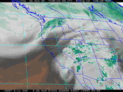
Hurricane Dean Moisture Produces
Some Showers. Remnant moisture from Hurricane Dean produced a few showers around the area over the weekend. Some shower activity has continued today, mainly to the north of Los Angeles, in the Lockwood Valley area and in the Sierra, extending east into Nevada. |
More information
concerning Southern California weather can be found using our WEATHER
LINKS page. |
|
|
Cool July! Southern California
Winter Precipitation Outlook. Have you noticed it's been cooler this summer? Last year Pierce College in Woodland Hills recorded a high temperature of at least 100°F on 25 of 31 days in July, culminating in a sweltering record high of 119°F. This year only 10 days in July reached the 100° mark at the school. |
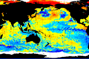
At Downtown Los Angeles (USC) the difference was even more pronounced. Last July the station recorded a high temperature of 90°F or above on 17 days, and the average high temp for the month was about 90°F. This July the temperature at Los Angeles never reached 90°F, and the average high temperature was about 83°F. Temps have been warmer this August and have ranged from about the same as last year to a little above. Virtually all international dynamic coupled climate models are forecasting cooler equatorial Pacific SSTs this Fall, trending towards neutral conditions this Spring. As a result, most longer range outlooks are similar to this Nov-Dec-Jan Precipitation Outlook from the CPC, and somewhat typical of a La Niña, with an increased chance of higher than normal precipitation in the Pacific northwest and a increased chance of lower than normal precipitation in the southwest. But based on this forecast, just how probable is it that Southern California will be drier than normal? Take a look at CPC's Probability of Exceedence Precipitation Outlook plot for coastal Southern California for the period Nov-Dec-Jan 2007-08. The telling point is that there is roughly an equal probability of below, near, or above normal precipitation. The forecast projects a 50% chance the actual precipitation will be between about 4" and 9", and a 90% chance it will be between about 2" to 14.6". That's quite a range! In his August 3, 2007 discussion of the Multivariate ENSO Index (MEI), Klaus Wolter points out that compared to four comparable ENSO events, the 2006-07 El Niño matches 1963-64 best in terms of its evolution, but the 1951-52 El Niño may be a better analog. As indicated by the value of the MEI, in 1963-64-65 the El Niño transitioned to a strong La Niña by Jun/Jul 1964 (-1.379), and then to near neutral conditions in Jan/Feb 1965 (-0.336). In comparison, in 1951-52-53 the El Niño transitioned to near neutral conditions in Jun/Jul 1952 (-0.196), and then to just below the weak El Niño threshold in Jan/Feb 1953 (0.405). Reflecting the uncertainty associated with neutral or near-neutral conditions, 13.69" of rain was recorded at Los Angeles during water year 1964-65, and 9.46" was recorded in the water year of 1952-53. Hopefully we will have at least a few inches more rain than last year. We'll see! More information concerning Southern
California weather can be found using our WEATHER
LINKS page. |
|
or Press your Browser's BACK button.