
NOTES ABOUT SOUTHERN CALIFORNIA WEATHER & CLIMATE
© 2000-2024 Gary Valle'. All Rights Reserved.
|
NOTES ABOUT SOUTHERN CALIFORNIA WEATHER & CLIMATE © 2000-2024 Gary Valle'. All Rights Reserved. |
IMPORTANT!! The
information presented on this web site may include errors of transcription,
interpretation, and other errors. The information may be out of date or
inaccurate. Please refer to the NATIONAL WEATHER SERVICE FORECAST OFFICE
LOS ANGELES or your local weather service office for official
forecasts and warnings. |
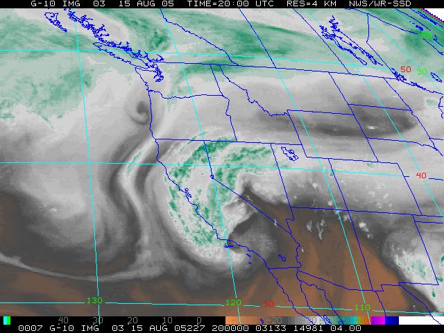 Upper Level Low Off Southern California Coast GOES-10 Water Vapor 08/15/05 |
Unseasonable
Upper Low Results in Thunderstorms. Neutral ENSO Conditions Expected. An unusual synoptic pattern for August -- diffluent flow aloft resulting from an upper level low off the coast of Southern California is producing isolated showers and thunderstorms over a wide area of the southern half of the state.
|
Much of the rain indicated on radar has not been making it to the ground, but measurable rain has been recorded by a few gauges. In the past 24 hours Sandberg has recorded 0.10 inch, Paso Robles 0.04 inch, and Kernville 0.35 inch. Several other locations have recorded amounts ranging from 0.01 inch to about 0.1 inch. Klaus Wolter's Multivariate ENSO Index (MEI) decreased from 0.48 for May/June to 0.42 in June/Jul, ranking it 36th of 56 values, where 1 is the strongest La Nina, and 56 the strongest El Niño for the bi-monthly period. This puts the MEI just below the "weak" tercile threshold for ranked El Niño events in June/July. According to the CPC/NCEP El Niño/Southern Oscillation (ENSO) Diagnostic Advisory, sea surface temperature (SST) anomalies decreased throughout the eastern equatorial Pacific during July, with equatorial SSTs above average west of the dateline and near average east of the dateline. As in the summer of 2004, most ENSO forecasts continue to predict neutral, or weakly warm near neutral conditions over the next few months. However, there are also some forecasts that predict warm (Scripps, LDEO) or cool (HiDyn) conditions. Various forecasts are referenced in the CPC's Forecast Forum, the International Research Institute's Summary of ENSO Model Forecasts, and the Australian Bureau of Meteorology National Climate Centre's summary of Forecast ENSO Conditions. We'll see! More information concerning Southern California weather can be found using our WEATHER LINKS page. |
|
