
NOTES ABOUT SOUTHERN CALIFORNIA WEATHER & CLIMATE
© 2000-2024 Gary Valle'. All Rights Reserved.
|
NOTES ABOUT SOUTHERN CALIFORNIA WEATHER & CLIMATE © 2000-2024 Gary Valle'. All Rights Reserved. |
IMPORTANT!! The
information presented on this web site may include errors of transcription,
interpretation, and other errors. The information may be out of date or
inaccurate. Please refer to the NATIONAL WEATHER SERVICE FORECAST OFFICE
LOS ANGELES or your local weather service office for official
forecasts and warnings. |
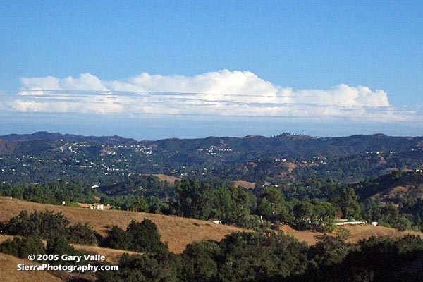 Afternoon clouds, southeast of Los Angeles From Ahmanson Ranch 4:30 PM PDT 09/19/05 |
Southern California
Thunderstorms the Result of Hurricane Max? Much of yesterday blue, cloudless skies prevailed in the Los Angeles area, and the only hint of moisture on the air was near swimming pools and over-watered lawns... and on computer screens displaying the sometimes magical predictions of the NCEP weather models.
|
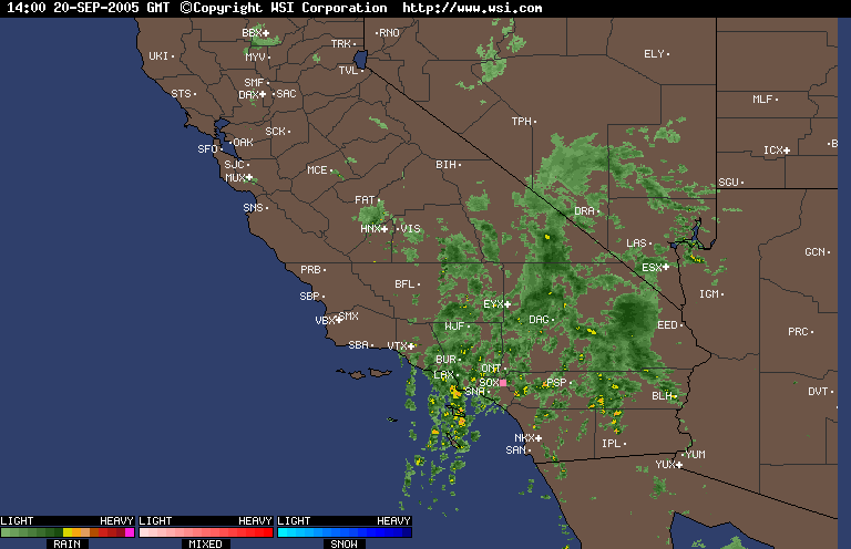
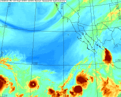
But by the late afternoon clouds were on the increase south of the Los Angeles basin and by evening Orange County residents were dodging raindrops and thunderstorms. Overnight a south-to-north line of enhanced precipitation has moved very slowly to the west and additional areas of precipitation have developed over much of Southern California. As of 8:00 this morning, rainfall totals have generally been in the 0.05 to 0.1 range, but with some isolated 0.25 to 0.50 inch totals in areas affected by thunderstorms. Some news outlets are reporting that our rainfall is due to moisture from Hurricane Max in the eastern Pacific. This animated GIF of GOES-10 water vapor satellite photos from NRL shows a more complex interaction, involving an upper low off the west coast, circulation around Max and a high over Texas. There are multiple sources of moisture, with much of the moisture originating from the subtropics and ITCZ. As Max dissipates, its remnants may more directly affect the weather in the western states. Klaus Wolter's Multivariate ENSO Index (MEI) increased slightly from 0.42 in June/Jul to 0.43 in Jul/Aug, ranking it 37th of 56 values, where 1 is the strongest La Nina, and 56 the strongest El Niño for the bi-monthly period. This puts the MEI just below the "weak" tercile threshold for ranked El Niño events in June/July. According to the CPC/NCEP El Niño/Southern Oscillation (ENSO) Diagnostic Advisory, sea surface temperature (SST) anomalies decreased throughout the eastern equatorial Pacific during July, with equatorial SSTs above average west of the dateline and near average east of the dateline. As in the summer of 2004, most ENSO forecasts continue to predict neutral, or weakly warm near neutral conditions over the next few months. However, there are also some forecasts that predict warm (Scripps, LDEO) or cool (HiDyn) conditions. Various forecasts are referenced in the CPC's Forecast Forum, the International Research Institute's Summary of ENSO Model Forecasts, and the Australian Bureau of Meteorology National Climate Centre's summary of Forecast ENSO Conditions. We'll see! Update 09/21/05 7:00 A.M. Yesterday's rainfall total at Los Angeles (USC) of 0.29 inch was a new record for the date, eclipsing the old record of 0.05 inch set back in 1983. More information concerning Southern California weather can be found using our WEATHER LINKS page. |
|
