
NOTES ABOUT SOUTHERN CALIFORNIA WEATHER & CLIMATE
© 2000-2024 Gary Valle'. All Rights Reserved.
|
NOTES ABOUT SOUTHERN CALIFORNIA WEATHER & CLIMATE © 2000-2024 Gary Valle'. All Rights Reserved. |
IMPORTANT!! The
information presented on this web site may include errors of transcription,
interpretation, and other errors. The information may be out of date or
inaccurate. Please refer to the NATIONAL WEATHER SERVICE FORECAST OFFICE
LOS ANGELES or your local weather service office for official
forecasts and warnings. |
Previous Month - Index - Next Month
|
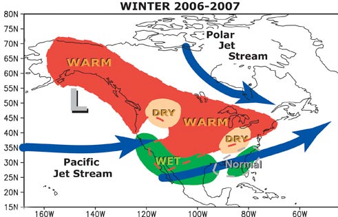
NOAA Releases Updated Winter
Outlook. El Niño Continues to Strengthen. NOAA released an updated Winter Outlook on October 19. The outlook is based on the most recent U.S. Seasonal Outlook, and takes into account expected impacts resulting from the developing El Niño. |
Over the past three weeks the Southern Oscillation Index (SOI) has dropped from about -8 to about -16 and another westerly windburst has occurred in the western equatorial Pacific. TAO/TRITON 5-Day Depth Averaged Temperature data shows two large areas of anomalies of 1.7 °C or more. All this suggests continued strengthening of the El Niño. Dr. Klaus Wolter's Multivariate ENSO Index (MEI) has increased more than 1.4 standard deviations in five months, and the value for September/October will likely continue this upward trend. No El Niño impacts here yet, just great Autumn weather. NCEP's GFS, Ensemble Forecast Means and Probabilistic Precipitation Forecasts suggest the generally mild pattern should continue over the next 7-10 days, with varying degrees of low clouds and fog at the lower elevations. We'll see! More information concerning Southern
California weather can be found using our WEATHER
LINKS page. |
|
|
Chance of Showers. MEI Above
Moderate El Niño threshold. Initial NOAA Winter Outlook
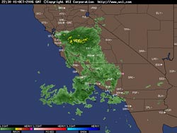
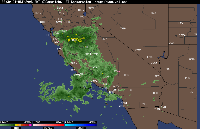
Released. An upper level low that produced several inches of snow at South Lake Tahoe and Mammoth Mountain earlier this week is now located off the coast of Southern California and spinning bands of showers into the area. |
So far, most of the precipitation has been north and west of the Los Angeles basin. According to the CNRFC Interactive Precipitation Map, in the six hour period ending at 10:00 a.m. stations in Ventura, Santa Barbara, San Luis Obispo and Kern counties have recorded amounts varying from 0.02 inch at Oxnard, to 0.14 inch at Ojai, and 0.20 inch at Paso Robles. At 9:00 a.m. Intellicast radar showed a band of showers with possible embedded thunderstorms extending from southeast of Bakersfield to the Paso Robles area. Depending on the track of the upper low, and several other factors, there should be a continuing chance of showers or thundershowers into Saturday. If the BUFKIT analysis of 12z ETA model proves correct, a chance of drizzle or light showers might extend into Sunday morning. The 12z ETA and GFS model projections suggest rainfall amounts ranging from about 0.05 inch to about 0.25 inch, with the 09z SREF indicating about 0.1 inch in the Los Angeles area. We'll see! Dr. Klaus Wolter's Multivariate ENSO Index (MEI) for August/September increased to 0.892. This is an increase of more than 1.4 standard deviations in five months, and moves the MEI to just above the moderate El Niño threshold, as defined by the index. NOAA released it's initial Winter Outlook on October 11. The outlook is based on the most recent U.S. Seasonal Outlook, issued September 21, and takes into account the developing El Niño. More information concerning Southern
California weather can be found using our WEATHER
LINKS page. |
|
|
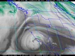
First Autumn Showers. NOAA
Issues Unscheduled El Niño Advisory. TAO/TRITON Moorings
Vandalized. The first widespread measurable rain of the 2006-2007 rain season moved into Southern California yesterday, and continued overnight. Some showers were briefly heavy -- indicative of the convective nature of the precipitation. Rainfall amounts around the area were generally around a 0.1 inch or less. As of 7:00 this morning, Simi Valley APCD recorded 0.21 inch and Thousand Oaks recorded 0.31 inches of rain. |
In an unscheduled advisory, issued September 13, 2006, NOAA announced that El Niño conditions had developed in the tropical Pacific and could strengthen into a moderate event by winter. Some impacts of the El Niño have already been observed, and typical El Niño temperature and precipitation patterns are expected to develop in North America this winter. We'll see! According to the TAO/TRITON web site, TAO moorings in the tropical Pacific east of 125°W have been vandalized and are scheduled for replacement in November 2006. The TAO/TRITON array is a major component of the ENSO Observing System. More information concerning Southern
California weather can be found using our WEATHER
LINKS page. |
|
or Press your Browser's BACK button.

