
NOTES ABOUT SOUTHERN CALIFORNIA WEATHER & CLIMATE
© 2000-2024 Gary Valle'. All Rights Reserved.
|
NOTES ABOUT SOUTHERN CALIFORNIA WEATHER & CLIMATE © 2000-2024 Gary Valle'. All Rights Reserved. |
IMPORTANT!! The
information presented on this web site may include errors of transcription,
interpretation, and other errors. The information may be out of date or
inaccurate. Please refer to the NATIONAL WEATHER SERVICE FORECAST OFFICE
LOS ANGELES or your local weather service office for official
forecasts and warnings. |
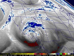 GOES-10 Water Vapor Satellite Image From 10/18/05 14:00z 7:00 AM PDT |
Cut-off Low Continues to Soak
Southland. |
Yesterday afternoon strong thunderstorms produced gusty winds, heavy rain and hail. Reports compared the size of the hail in various areas to peas, dimes, mothballs and walnuts. A severe thunderstorm developed near Los Angeles, and tracked to the northwest, producing heavy rain in Burbank, Santa Clarita and the Grapevine. Flash flooding and mudslides were reported in the Burbank and Gorman burn areas, and closed I-5 for about 4 hours. This morning at 6:45 PDT, Intellicast.com composite radar showed rain continuing in many areas. So far, rainfall totals for the storm have generally ranged from about 1.0 to 2.0 inches, with higher totals reported in some foothill and mountain locations, and lower totals to the south of the basin. Last year, a series of unseasonably strong systems also resulted in very heavy October rains. See the October 2004 Weathernotes for more information. The 12z NAM forecasts the low to be centered near the Four Corners area by early tomorrow morning. As the low moves inland, showers are generally expected to taper off and should end in most areas of Southern California tonight. After that it looks like no rain for at least several days. We'll see! More information concerning Southern
California weather can be found using our WEATHER
LINKS page. |
|
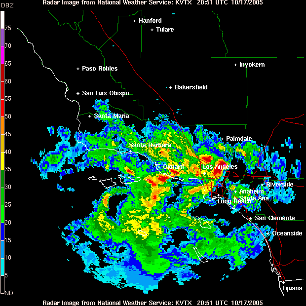
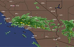 Intellicast.com Composite Radar From 10/17/05 11:30z 4:30 AM PDT |
Cut-off Low Produces
Showers and Thunderstorms. Flash Flood Watch in Burn Areas. |
As of 7:00
a.m. PDT the highest rainfall totals have been in the San Gabriel
Valley and adjacent foothills and mountains, with over an inch of
rain recorded in several locations. Remote Automated Weather Stations
(RAWS) in and near the Topanga
fire area (Oct. 2 map) have recorded about 0.1 to 0.2 inch,
and 0.3 inch was recorded by a gauge in West Hills. |
|
The exact timing and track differ, but the 12z NAM and GFS models show the low moving to the ENE into Arizona by sometime tomorrow (Tuesday) evening. A Flash Flood Watch issued by the NWS at 8:10 a.m. PDT today (Monday) warned of the possibility of heavy rain, with the potential for flash flooding and debris flows in recent burn areas through Tuesday afternoon. The image to the right shows burned slopes below Simi Peak. |
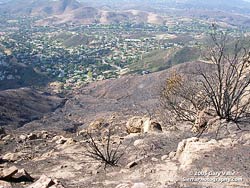 Burned slopes below Simi Peak - 10/16/05 |
Update 10/17/05 2:00 PM - NWS composite radar indicated moderate to heavy precipitation in areas of Los Angeles and Ventura counties. Some very strong embedded thunderstorms were indicated. Hail and heavy rain have been reported in several areas. |
|
More information concerning Southern California weather can be found using our WEATHER LINKS page. |
|
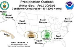 NOAA Winter Precipitation Outlook Issued 10/12/05 |
NOAA Releases
Winter Outlook. Cut-off Low May Result in Showers. NOAA released its initial Winter
Outlook yesterday. The outlook won't be much help to those
trying to divine the amount of rainfall in Southern California
this season, prescribing neither wet, dry or normal precipitation
this Winter. The reason: NOAA does not expect La Niña
and the El Niño/Southern Oscillation (ENSO) to play a
role in this Winter's forecast. |
But... there is little agreement among ENSO forecasts and certainly no consensus regarding equatorial sea surface temperatures (SSTs) a few months from now. At the moment equatorial SSTs are somewhat similar to the those observed in the Fall of 2003. Forecasts range from the warm scenario of the Scripps/MPI forecast to the cool prediction of the POAMA forecast from the Australian Bureau of Meteorology. Other forecasts are about equally divided between gradations of warm and cool. Given the current equatorial SSTs, forecasts, and analysis, the conservative prediction would be for about average rainfall this season. But if SST anomalies increase we could see another season of above average rainfall. We'll see! Speaking of which -- recent runs of most computer models have been forecasting that a trough diving into California this weekend, will cut off into an upper low centered somewhere near San Diego Sunday morning, and then wobble around for a couple of days before filling and moving east. Depending on exactly how and where the low wobbles, and how much moisture it entrains, there's a chance it could produce some showers in Southern California beginning later tonight and ending Tuesday afternoon -- or whenever the low moves out of the area. The 12z runs of the NAM and GFS produce about 0.3 inch of rain at Los Angeles during this period. Showers or not, it will be much cooler than it has been the last few days. More information concerning Southern California weather can be found using our WEATHER LINKS page. |
|
