
NOTES ABOUT SOUTHERN CALIFORNIA WEATHER & CLIMATE
© 2000-2024 Gary Valle'. All Rights Reserved.
|
NOTES ABOUT SOUTHERN CALIFORNIA WEATHER & CLIMATE © 2000-2024 Gary Valle'. All Rights Reserved. |
IMPORTANT!! The
information presented on this web site may include errors of transcription,
interpretation, and other errors. The information may be out of date or
inaccurate. Please refer to the NATIONAL WEATHER SERVICE FORECAST OFFICE
LOS ANGELES or your local weather service office for official
forecasts and warnings. |
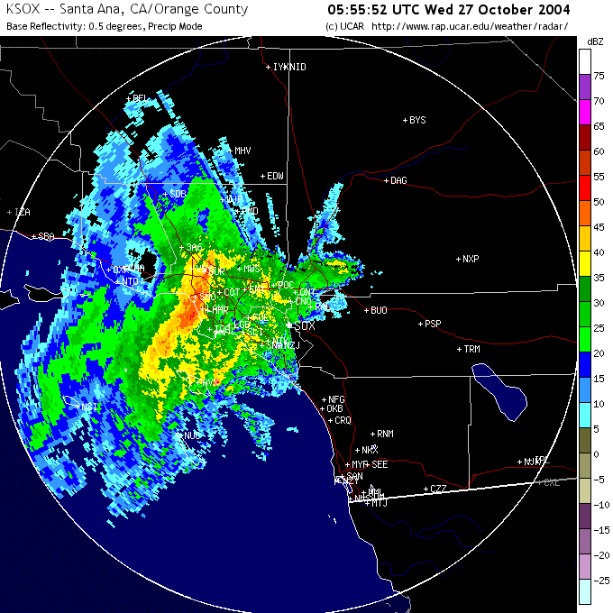 NEXRAD Radar Image 10/26/04 10:56 PM PDT |
Weathernotes for Wednesday, October 27, 2004Rain rates in excess of an inch an hour were observed as the cold front associated with a strong Pacific system moved through the Los Angeles basin overnight. Rainfall totals were generally less than amounts forecast by the computer models, but still notable for the month of October. Generally, 24 hour preliminary rainfall totals ranged from about 1.0-1.5 inches in coastal and valley areas to 2.0-4.0 inches in the mountains. Some additional rain is likely today as cold air aloft, vorticity, and daytime heating combine to produce showers of varying intensity, and possible thunderstorms. |
More information concerning Southern California weather can be found using our WEATHER LINKS page. |
|
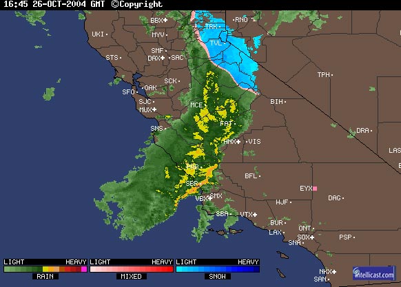 Intellicast Composite Radar 10/26/04 9:45 AM PDT |
Weathernotes for Tuesday, October 26, 2004Radar and satellite show impressive system bearing down on Southern California. All the ingredients coming together for rain event with strong winds, high rain rates and large precipitation totals. Today's 12z ETA generates even more rain at Los Angeles than yesterday's 18z run, with over 4 inches forecast. Some mountain areas could receive double this amount or more, with totals similar to last week's storm. |
More information concerning Southern California weather can be found using our WEATHER LINKS page. |
|
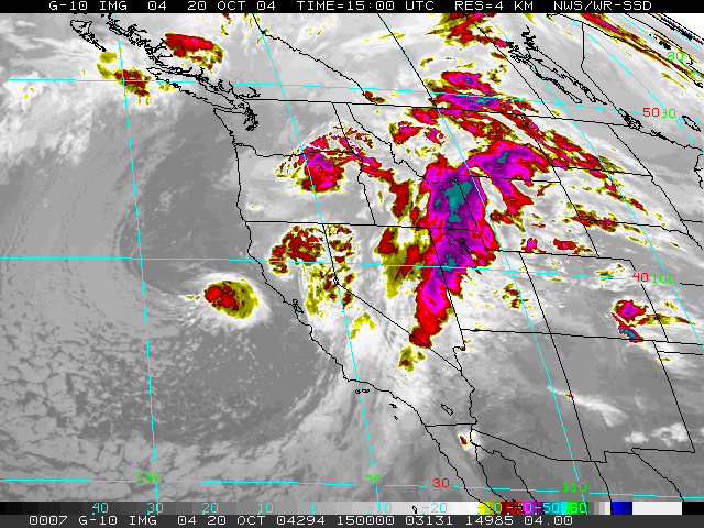 GOES-10 IR Satellite Image 10/20/04 8:00 AM PDT |
Weathernotes for Friday, October 22, 2004A series of three Pacific systems resulted in an early start to the rainy season in Southern California, ending months of dry weather, and moderating explosive fire conditions. Rainfall totals for the period October 16-20 ranged from about 3.0 to 4.0 inches in the lowlands to over 10.0 inches in the mountains. OPIDS Camp near Mt. Wilson recorded more than 17.0 inches for the period. |
All that water had to go somewhere, and flooding of streets, low lying areas and stream channels was widespread. Early Wednesday morning flow gages on the Los Angeles River recorded peak flows at Sepulveda Dam of 10,200 cubic feet of water per second (cfs), at Firestone Blvd. 42,836 cfs, and at Wardlow St. 51,428 cfs! NOAA released it's updated Winter Outlook October 21st. The outlook forecasts "equal chances" of below average, average, or above average precipitation for Southern California for the period Dec-Feb, but maintains an increased chance of above average precipitation for Jan-Mar, Feb-Apr and Mar-May. Whether the current El Niño evolves into a moderate event could significantly alter its impact on Southern California weather. Generally, the stronger the El Niño, the more precipitation in the the southern half of California. The development of the current El Niño stalled somewhat last month, but during the last 30 days an area of equatorial SST anomalies near the date line has increased to above 1.5°C. This may have been due in part to an area of enhanced tropical convection associated with the Madden-Julian Oscillation earlier in October. Update 10/25/04 4:00 PM - Latest model runs have increased rainfall amounts forecast for tomorrow's storm. The 18z GFS generates about 2.5 inches for Los Angeles, and the 18z 40km ETA generates a whopping 3.8 inches. The GFS forecasts the onset of precipitation in Los Angeles for around mid-day, while the ETA hold it off until the afternoon. Update 10/24/04 4:00 PM - Models have been having a tough time with the Tuesday-Wednesday system, but may finally be reaching a consensus with the 18z runs. The 18z GFS generates about 1.25 inch for Los Angeles, and the 18z 40km ETA generates about 1.3 inches. The GFS is several hours faster with the onset of precipitation, forecasting rain in Los Angeles beginning around mid-day, while the ETA hold it off until the evening. 10/22/04 - At least for the moment, the GFS appears to be trending towards a drier forecast for the system expected to move through the area in the Tuesday to Wednesday timeframe, with only about 0.20 inch forecast for Los Angeles by the 12z GFS model run. We'll see! More information concerning Southern California weather can be found using our WEATHER LINKS page. |
|
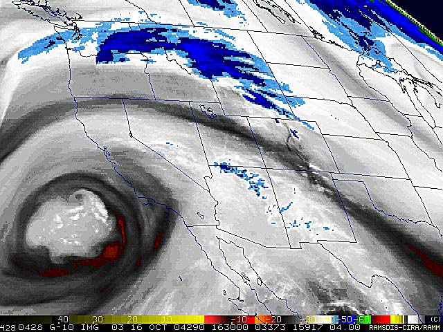 Upper Low Off California Coast 10/16/04 |
Weathernotes for Saturday, October 16, 2004This RAMDIS water vapor satellite image from early this morning has been enhanced to emphasize the secondary vorticity centers pin-wheeling around the low center off the Southern California coast. A GOES satellite sounding from yesterday showed a 500mb temperature of -18°C, CAPE of 813 J/Kg, and LI of -5 near the center of the low. |
The upper low, the first of three systems forecast to move through the area over the next few days, is expected to produce the first significant rainfall in Los Angeles since April 18th. In a Special Weather Statement issued this afternoon, the NWS estimated this first system would produce rainfall amounts ranging from about 0.25"-0.75" in coastal and valley areas, and up to 1.5" in the mountains. Computer models differ on the timing and amount of precipitation forecast, with the ETA slower and drier than the GFS. A BUFKIT analysis based on 12z ETA data for Van Nuys produces about 0.15" of rain from the system, beginning around 2:00 am. Analysis of 12z GFS data produces about 0.33" of rain, beginning around 11:00 pm. The 20-25 knots of moist southwesterly inflow forecast by the GFS would result significant orographic enhancement of rainfall on southwest facing foothill and mountain slopes. The ETA forecasts a much weaker inflow of 13-14 knots. Instability associated with the low could produce some thunderstorms. Another system follows closely on the heels of the first. BUFKIT analysis suggests rainfall totals similar to the first system, except that west facing slopes may see the most orographic enhancement. The third, and potentially wettest system of the series, is currently progged by the GFS to move into the area late Tuesday afternoon, but that could change with later forecasts. We'll see! More information concerning Southern California weather can be found using our WEATHER LINKS page. |
|
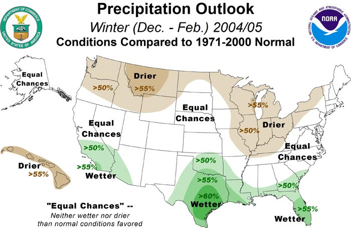 NOAA Winter Precipitation Outlook 10/06/04 |
Weathernotes for Saturday, October 9, 2004NOAA released it's initial Winter Outlook Wednesday. As expected, the outlook "reflects a blend of impacts associated with weak-to-moderate El Niño events in the central equatorial Pacific Ocean and is based on the likelihood that these conditions will persist through early 2005." |
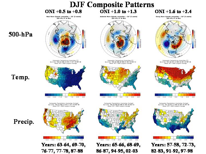
The long term Precipitation Outlooks, issued by the CPC September 16, 2004, start to show an El Niño like pattern with the Dec-Jan-Feb Precipitation Outlook. The CPC's discussion of these forecasts takes a wait and see attitude, and stresses that El Niño impacts will "depend critically on the evolution of SSTs in the eastern Pacific and the coupling between the atmosphere and SST anomalies." Whether the current El Niño evolves into a moderate event could significantly alter its impact on Southern California weather. As discussed in the last Weathernotes, generally, the larger the SST anomaly in the Niño 3.4 region, the more precipitation in Southern California. This is well illustrated in this graphic of 500-hPa height and height anomalies, surface temperature anomalies and precipitation for weak, medium and strong El Ninos. (From the Climate Prediction Center's ENSO Diagnostic Discussion, issued October 7.) Other factors, such as the Pacific Decadal Oscillation (PDO) and the North Atlantic Oscillation (NAO), may also modify the impacts of this El Niño Increases in the Multivariate ENSO Index (MEI) and decreases in the Southern Oscillation Index (SOI) stalled in September. The Aug/Sep value of the MEI was 0.577, down slightly from 0.602 in Jul/Aug. The SOI decreased from -7.6 in August to -2.8 in September. In a survey of eleven ENSO forecasts updated September 29, 2004, only two models predict NINO3 anomaly exceeding +0.8°C as of February 2005. However, it should also be noted that the latest value of the MEI ranks it in the upper third (39/55) of MEI values for the season. According to Dr. Klaus Wolter, the MEI behavior still resembles that recorded during 1979, which evolved to a moderate El Niño event during the Winter of 1979-80. While current conditions and model forecasts suggest that the El Niño of 2004-2005 may remain weak, with little impact on Southern California, it is really too early to tell. ENSO forecast models have only modest skill, and it is not unusual during an El Niño event for significant index increases to occur in mid-winter, or even late winter. In 1979-1980 the MEI increased from 0.699 in Sep/Oct to 1.034 in Nov/Dec; and in 1991-1992 it increased from .755 in Aug/Sep to 2.247 in Mar/Apr! Based on the information that is currently available, the prudent climatologist would probably forecast "more or less average" precipitation in Southern California with a slightly increased chance of above average rainfall. But should the pattern continue to evolve like the El Niño of 1979-80, and behave in a similar manner, Southern California could receive more rain than normal. We'll see! Note: There was a typo in the September 16 Weathernotes. The reference to the precipitation total for the 1979-1980 water year should have read 'over 26" of rain.' The uncertified total for 1979-1980 listed in the Water Year Rainfall totals on the NWS Downtown Los Angeles Climate page is 26.98 inches. More information concerning Southern California weather can be found using our WEATHER LINKS page. |
|
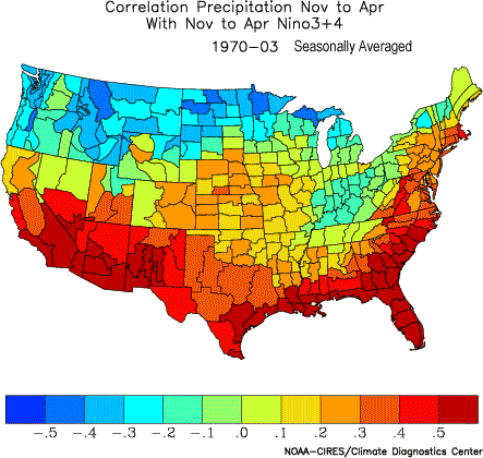 Correlation Nov to Apr Precipitation to Nino3+4 Index |
Weathernotes for Thursday, September 16, 2004According to Dr. Klaus Wolter in the September 3, 2004 update of the Multivariate ENSO Index (MEI) page, the latest increase of the MEI Index from .454 to .602 "virtually guarantees" weak to moderate El Niño conditions this Fall and Winter. At this point the MEI behavior resembles that recorded during 1979, which evolved to a moderate El Niño event during the Winter of 1979-80. |
The Climate Prediction Center's ENSO Diagnostic Discussion, issued September 9, reports that the operational definition an El Niño was satisfied for the period June-August 2004, and that it "seems most likely that SST anomalies in the Niño 3.4 region will remain positive, at or above +0.5°C, through early 2005." If mild to moderate El Niño conditions persist this Winter, what might be the impact on Southern California? Climate Diagnostics Center (CDC) data analysis tools show the expected positive correlation of seasonally averaged November to April Southern California precipitation to Niño 3.4 (East Central Tropical Pacific) SST. Generally, the larger the SST anomaly in the Niño 3.4 region, the more precipitation in Southern California. However, there is growing evidence that other ocean-atmosphere interactions, such as the Pacific Decadal Oscillation (PDO), can lessen or amplify ENSO impacts. The PDO characterizes the state of Pacific SSTs north of the tropics. Results vary from region to region, but generally ENSO impacts are the most defined when ENSO and the PDO are in phase. The warm phase of the PDO is characterized by cooler than normal SSTs in the central Pacific, east of Japan; and warmer than normal SSTs off the west coast of North America, and in the tropical Pacific. The PDO index has been positive since August of 2002, with higher index values the Winter of 2002-2003, than in the Winter of 2003-2004. Current SST animations suggest the PDO could be moderately to strongly positive this Winter. CDC data analysis tools show a weak positive correlation of seasonally averaged November to April Southern California precipitation to the PDO index. The long term Precipitation Outlooks, issued by the CPC September 16, 2004, start to show an El Niño like pattern with the Dec-Jan-Feb Precipitation Outlook. The CPC's discussion of these forecasts takes a wait and see attitude, and stresses that El Niño impacts will "depend critically on the evolution of SSTs in the eastern Pacific and the coupling between the atmosphere and SST anomalies." Should the pattern continue to evolve like the El Niño of 1979-80, and behave in a similar manner, Southern California could experience a very wet Winter. That rainy season Los Angeles received over 26" [typo corrected] of rain. This weekend an unseasonably strong upper trough may result in some showers. We'll see what this Winter brings! More information concerning Southern California weather can be found using our WEATHER LINKS page. |
|
