NOTES ABOUT SOUTHERN CALIFORNIA WEATHER & CLIMATE
© 2000-2024 Gary Valle'. All Rights Reserved.
|
NOTES ABOUT SOUTHERN CALIFORNIA WEATHER & CLIMATE © 2000-2024 Gary Valle'. All Rights Reserved. |
IMPORTANT!! The
information presented on this web site may include errors of transcription,
interpretation, and other errors. The information may be out of date or
inaccurate. Please refer to the NATIONAL WEATHER SERVICE FORECAST OFFICE
LOS ANGELES or your local weather service office for official
forecasts and warnings. |
Previous Month - Index - Next Month
|
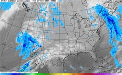
Rainfall Records Broken
in Southern California. Happy Thanksgiving! Our record-setting upper low system is slowly moving east out of the area, but this morning there's still some shower activity occurring south and east of the Los Angeles basin. The best chance of showers today is in the mountains, and areas south and east of the basin, but a shower could pop up just about anywhere in Southern California. |
Rainfall totals for the storm have generally ranged from 1.0 to 2.0 inches in the coastal and valley areas, with some higher amounts recorded in foothill and mountain locations. Rainfall records for November 26th were broken at several locations, including Lancaster, Palmdale, Sandberg, UCLA, Burbank, Woodland Hills, and San Gabriel. OPIDS Camp, in the San Gabriel Mountains has recorded 3.29 inches. Here are some preliminary rainfall totals from the NWS. Through yesterday, Downtown Los Angeles (USC) has recorded a storm total of 1.60 inches, bringing the water year total to 1.87 inches, which is 0.17 inches above normal for the date. More information
concerning Southern California weather can be found using our WEATHER
LINKS page. |
|
|
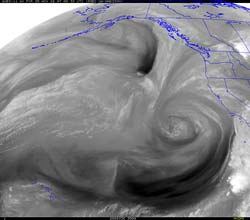
Upper Low Expected to
Drench Southern California. NOAA Releases Winter Precipitation
Outlook. In the past week the weather models have been all over the map -- and sometimes off of it -- trying to come up with a forecast for this week and the Thanksgiving holidays. Now that a potent looking upper level low system is bearing down on the Southland, the 18z NAM and 18z GFS both agree we are going to get drenched. |
The Hydrometeorological Prediction Center (HPC) is projecting from one to two inches of rain over a large area of Southern California. BUFKIT analysis of 18z data for Van Nuys generates rainfall totals of in excess of 2 inches for the storm. Depending on the strength of the southerly inflow, rainfall totals could be higher on south facing foothill and mountain slopes. Radar is already showing some echoes aloft, and some showers could occur overnight and into tomorrow. Rain is expected to begin in earnest during the day tomorrow, perhaps as late as tomorrow afternoon or evening, and taper off late Wednesday night into Thursday morning. NOAA has just released their 2008-2009 Winter Outlook. The precipitation outlook for December through February indicates an equal chance of below normal, near normal, or above normal precipitation for California. The IRI Multi Model Seasonal Forecast for Dec-Jan-Feb indicates below average precipitation is slightly more likely in southern third of California. Update 11/25/08. BUFKIT analysis of 12z NAM and GFS data for Van Nuys isn't quite as wet as yesterday's 18z run. Over the next 36 hours, the 12z GFS generates about 0.8 inch, and the 12z NAM about 1.7 inch of rain, with maximum rain rates of about 0.4 inch/hour. Rain is expected to move into the Los Angeles area later this afternoon or evening. More information concerning Southern
California weather can be found using our WEATHER
LINKS page. |
|
or Press your Browser's BACK button.