
NOTES ABOUT SOUTHERN CALIFORNIA WEATHER & CLIMATE
© 2000-2024 Gary Valle'. All Rights Reserved.
|
NOTES ABOUT SOUTHERN CALIFORNIA WEATHER & CLIMATE © 2000-2024 Gary Valle'. All Rights Reserved. |
IMPORTANT!! The
information presented on this web site may include errors of transcription,
interpretation, and other errors. The information may be out of date or
inaccurate. Please refer to the NATIONAL WEATHER SERVICE FORECAST OFFICE
LOS ANGELES or your local weather service office for official
forecasts and warnings. |
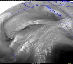 UW GOES-10 Water Vapor Satellite Image From 11/28/05 22:30z 2:30 PM PST |
Heavy Snow Forecast for Sierra.
Negative SST Anomalies in Nino 1+2, Nino 3 and Nino 3.4 Regions. |
The HPC 3 day precipitation forecast issued at noon today (Monday) shows up to 6 inches (water equivalent) of precipitation in the Northern Sierra from this afternoon through Thursday afternoon. As the pattern evolves this week, there is a possibility of a shortwave in the southern stream phasing with a northern stream trough, and the focus of the westerlies shifting southward. With continued entrainment of moisture from around 20° N, this could produce heavy, orographically enhanced snowfall at higher elevations of the Central, and perhaps, Southern Sierra. Model solutions are still varying from run to run and model to model, so it's really too early to say what might happen down this way, but it looks like there is at least the potential for some wet weather later in the week and over the weekend. We'll see! Klaus Wolter's Multivariate ENSO Index (MEI) for Sep/Oct dropped below -0.2 for the first time since Oct/Nov 2001. According to Dr. Wolter, "the recent drop into negative values shows that this is not a 'normal' year, and a further drop into true La Niña conditions appears possible." As of November 23, 2005, negative SST anomalies existed in the Nino 1+2, Nino 3 and Nino 3.4 regions. More information concerning Southern
California weather can be found using our WEATHER
LINKS page. |
|
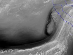 UW GOES-10 Water Vapor Satellite Image From 11/08/05 16:30z 8:30 AM PST |
Upper Low Threatens Rain.
ENSO Neutral... For Now. MJO Won't Start. Computer models have been having a hard time getting a handle on the evolution of a system that brought some rain to Northern California yesterday. The system has split, and a closed upper low is developing off the west coast. Just where the upper low cuts off and where it goes after that are the tough questions, and the ones that are key to the forecast. A little more on or off shore, or north or south, could change rain amounts dramatically. |
The 12z runs of the NAM and GFS weather models suggest there's at least a chance of rain developing in Southern California over the next 24-36 hours. When and how much are more difficult questions. The 12z NAM says about 0.7 inch of rain at Los Angeles, beginning in the middle of the night. The 12z GFS says about 0.25 inch, starting tomorrow morning. Whatever rain does fall, if the low behaves itself, the rain threat should end by Thursday. After that it looks like an extended period of mostly dry weather is possible. We'll see! Neutral ENSO conditions continue in the equatorial Pacific and the majority of outlooks say this is more or less what we should expect the next few months. In the absence of El Niño and La Nina another cyclic weather phenomenon, the Madden-Julian Oscillation (MJO), can become an important factor in our weather. While an El Niño episode might extend over one or two rain seasons, multiple MJO's can occur in just one rain season. A recurring MJO can lead to periods of west coast precipitation, and heavy rain events. So far this Fall the MJO has been like a car that almost - but- does - not - quite - start and continue to run. Current forecasts suggest the MJO will remain weak for the next 6-10 days. Klaus Wolter's Multivariate ENSO Index (MEI) for Sep/Oct dropped below -0.2 for the first time since Oct/Nov 2001. According to Dr. Wolter, "the recent drop into negative values shows that this is not a 'normal' year, and a further drop into true La Niña conditions appears possible." Following are links to TAO/TRITON Equatorial SST Means and Anomalies for November 7, 2005 and November 7, 2001, and the NOAA/NESDIS Global SST Anomaly for November 5, 2005 and November 5, 2001. Update 11/10/05 7:00 A.M. Cut-off upper low continues to spin WSW of Pt. Conception and has produced precipitation ranging from light rain in the Los Angeles basin to heavier rainfall in orographically favored slopes of the Ventura and Santa Barbara mountains. As of 4:00 A.M. rainfall totals for the storm have generally ranged from about 0.25 to 0.50 inch in the Los Angeles area to about 1.00 to 2.00 inches in the Santa Barbara area, with higher totals at some Ventura and Santa Barbara mountain locations. Finally on the same page, both the NAM and GFS drop the upper low southward today, and into northern Baja early tomorrow morning, with the GFS track a little more to the south than the NAM's. Update 11/09/05 7:00 A.M. For now, the cut-off upper low has set up shop just a little too far off shore to bring widespread rain to the area, but that does not mean that it hasn't been raining in Southern California. Coastal areas in San Luis Obispo, Santa Barbara and Ventura counties, closer to the low center, have been seeing measurable rain, with as much as 0.8 inch reported in some mountain locations near Santa Barbara. This morning, WSI Intellicast.com composite radar shows the extent of the precipitation. This experimental NWS RIDGE Radar graphic shows rain echoes within range of the radar (near Ojai), but not all of the rain in the geographic area depicted. Differences in the NAM and GFS forecasts continue, with the 12z NAM generating about 0.5 inch or precipitation at Los Angeles, and the 06z GFS about 0.15 inch. The NAM ends the rain by tomorrow (Thursday) morning, but the GFS indicates a chance of very light rain continuing through the day on Thursday. More information concerning Southern
California weather can be found using our WEATHER
LINKS page. |
|
