NOTES ABOUT SOUTHERN CALIFORNIA WEATHER & CLIMATE
© 2000-2024 Gary Valle'. All Rights Reserved.
|
NOTES ABOUT SOUTHERN CALIFORNIA WEATHER & CLIMATE © 2000-2024 Gary Valle'. All Rights Reserved. |
IMPORTANT!! The
information presented on this web site may include errors of transcription,
interpretation, and other errors. The information may be out of date or
inaccurate. Please refer to the NATIONAL WEATHER SERVICE FORECAST OFFICE
LOS ANGELES or your local weather service office for official
forecasts and warnings. |
Previous Month - Index - Next Month
|
Monsoon Pattern Results in
Flash Floods & Debris Flows. Monsoonal flow that began last Thursday has resulted in numerous thunderstorms in the mountains and deserts of Southern California, with flash flooding and debris flows reported in several locations. Areas in or near recently burned terrain are particularly susceptible, and flash floods and debris flows appear to have originated in the 2007 Oak Fire burn area in the eastern Sierra, and the still burning Piute Fire burn area near Lake Isabella. |
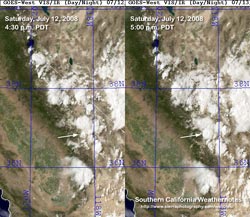
This sequence of three GOES-WEST VIS/IR satellite images from NRL's NEXSAT web site shows the explosive development of a convective cell north of Mt. Whitney on Saturday afternoon. This appears to be the thunderstorm that produced the heavy rain in the area burned by the Oak Fire, and resulted in the Oak Creek debris flow near Independence. Here's an AVI loop, generated on the NEXSAT web site, for the period 3:00 p.m to 6:00 p.m. PDT on Saturday. A particularly large thunderstorm cell/complex developed in the Sierra Nevada south of Mt. Whitney midday Saturday and drifted south down the Kern River drainage over the course of the afternoon. At about 2:45 p.m. the cell/complex was centered near the confluence of the Little Kern River and N.F. Kern River and measured about 44 miles in diameter. Here's a Google Earth image of the cell/complex with a 250m resolution True Color Aqua cloud layer imported from the MODIS Rapid Response System. This GOES-East/West Precipitable Water composite from 9:00 this morning indicates precipitable water values as high as 1.6" in some areas of Southern California, and the possibility of more mountain and desert thunderstorms continues today. Update July 25, 2008. The large cell/complex that developed south of Mt. Whitney on Saturday, July 12, and drifted south down the Kern River drainage appears to have produced the flash flooding and debris flows on Erskine Creek and other creeks in the Lake Isabella area late Saturday afternoon. This cell/complex can also be seen in sequence of three GOES-WEST VIS/IR satellite images and the AVI loop previously referenced. More information concerning Southern
California weather can be found using our WEATHER
LINKS page. |
|
or Press your Browser's BACK button.