
NOTES ABOUT SOUTHERN CALIFORNIA WEATHER & CLIMATE
© 2000-2024 Gary Valle'. All Rights Reserved.
|
NOTES ABOUT SOUTHERN CALIFORNIA WEATHER & CLIMATE © 2000-2024 Gary Valle'. All Rights Reserved. |
IMPORTANT!! The
information presented on this web site may include errors of transcription,
interpretation, and other errors. The information may be out of date or
inaccurate. Please refer to the NATIONAL WEATHER SERVICE FORECAST OFFICE
LOS ANGELES or your local weather service office for official
forecasts and warnings. |
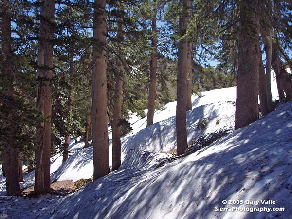 Snow Near Summit of Mt. Baden-Powell 07/03/05 |
Deep Snow and
Broken Trees After Big Winter Storms. This photo of a deep bank of melting snow was taken July 3, 2005, at an elevation of about 9000 ft., near the summit of Mt. Baden-Powell in Southern California's San Gabriel mountains. These drifts of snow, deposited in the lee of a south-facing ridge, are indicative of the extraordinary amount of precipitation received in Southern California during the Winter of 2004-2005. Nearby, trees such as this 24 inch diameter Jeffrey Pine, were uprooted and broken by hurricane force Winter winds.
|
As the raven flies, Mt. Baden-Powell is about 35 miles from the Downtown Los Angeles (USC) rain gauge, where 37.25 inches of rain was recorded for the period July 1, 2004 through June 30, 2005, making it the second wettest rain season on record. Following is a link to an archived copy of a NWS Public Information Statement from July 1, 2005, that summarizes the record setting rain year. Klaus Wolter's Multivariate ENSO Index (MEI) decreased from 0.71 for April/May to 0.48 in May/June, ranking it 38th of 56 values, where 1 is the strongest La Nina, and 56 the strongest El Niño for the bi-monthly value. This puts the MEI at the "weak" tercile threshold for ranked El Niño events in May/June. (The June 21, 2005 Weathernotes specified the latest MEI value was for May/June, when it was actually for April/May.) According to the CPC/NCEP El Niño/Southern Oscillation (ENSO) Diagnostic Advisory, sea surface temperature (SST) anomalies increased throughout the eastern equatorial Pacific during June, with positive equatorial SST anomalies observed in most areas between Indonesia and 90°W. TAO/TRITON data for the 5-day period ending July 10 shows two areas of SST anomoly exceeding 1.0 degree -- one near 165°E, and the other near 120°W. As in the summer of 2004, most ENSO forecasts are predicting neutral or weakly warm near neutral conditions over the next few months. However, there are also some forecasts that predict warm conditions. Various forecasts are referenced in the CPC's Forecast Forum, the International Research Institute's Summary of ENSO Model Forecasts, and the Australian Bureau of Meteorology National Climate Centre's summary of Forecast ENSO Conditions. We should have a better idea of whether we'll be dealing with another "weak" El Nino this Winter by late July or early August. We'll see! More information concerning Southern California weather can be found using our WEATHER LINKS page. |
|
