NOTES ABOUT SOUTHERN CALIFORNIA WEATHER & CLIMATE
© 2000-2024 Gary Valle'. All Rights Reserved.
|
NOTES ABOUT SOUTHERN CALIFORNIA WEATHER & CLIMATE © 2000-2024 Gary Valle'. All Rights Reserved. |
IMPORTANT!! The
information presented on this web site may include errors of transcription,
interpretation, and other errors. The information may be out of date or
inaccurate. Please refer to the NATIONAL WEATHER SERVICE FORECAST OFFICE
LOS ANGELES or your local weather service office for official
forecasts and warnings. |
|
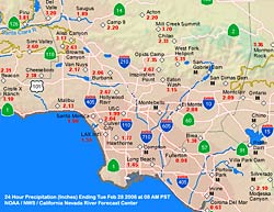
Pacific Storm Drenches Southland.
Chance of Showers Friday. A strong Pacific storm system drenched Southern California yesterday and overnight, behaving more or less as forecast and producing 2-3 inches of rain in the coastal and valley areas, and higher amounts in the mountains. This NOAA NWS California-Nevada River Forecast Center graphic shows some 24 hour precipitation totals from around the area. |
As of 9:55 A.M. Downtown Los Angeles (USC) has recorded 1.99 inches from the storm, bringing the (unofficial) water year total since July 1 to 7.32 inches -- about 3.5 inches below normal. There's still a chance of a shower this morning so these totals could change. Another Pacific system is forecast to work its way into the Pacific northwest coast over the next few days, bringing with it more rain and snow for Washington, Oregon and California. At the moment, it looks like the focus of this next system should be in Northern California. Most of the precipitation is forecast to occur north of the Los Angeles basin, but it looks like there is a chance of showers in our area Thursday evening into Friday. The 09z Short Range Ensemble Forecast (SREF) puts the probability of more than 0.1 inch of precipitation in the Los Angeles area, over a 24 hr. period ending mid-day Friday, at about 70%. We'll see! More information concerning Southern
California weather can be found using our WEATHER
LINKS page. |
|
|
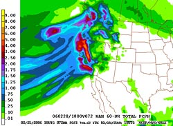
Pacific Storm Has Potential
to Produce Excessive Precipitation. A strong Pacific storm system is headed for Southern California, and has the potential to produce very heavy precipitation, particularly on south to southwest facing foothill and mountain slopes. Strong south-southwest inflow, high precipitable water values, and strong system dynamics could produce 2-4 inches, or more, of rain by Tuesday evening. |
Weather-wise this is an interesting storm. The main players are a cold full latitude trough with 500 mb temps around -30°C, and a warm plume of sub-tropical moisture with precipitable water values ranging from 1.0 to 1.5 inches. Add to that an embedded shortwave, a jet max developing in the base of the trough, surface wave development, 25 to 35 kt. low level southerly inflow, and it's a formula for rain -- maybe a lot of rain. An ARL (NOAA) meteogram of 18z NAM data for Van Nuys (VNY) accumulates a whopping 4 inches of rain from Monday morning to Tuesday evening. We'll see! Update 02/27/06 1:00 P.M. 06z, 12z and 18z NAM runs are projecting less rain than some earlier forecasts. A BUFKIT profile of 12z NAM data produces about 2 inches at Van Nuys, and an ARL (NOAA) meteogram of 18z NAM data for Van Nuys forecasts only about 1.72 inches rain -- 2.3 inches less than yesterday's 18z run. Even if these forecasts are accurate, this is still a lot of rain. There are many facets to this weather system, and variations in these elements could significantly increase or decrease precipitation. Given the high precipitable water values off the coast, forecast 30-50 kt. south-southwest inflow at 5000 ft., and fairly robust system dynamics, the potential for excessive rainfall certainly remains. More information concerning Southern
California weather can be found using our WEATHER
LINKS page. |
|
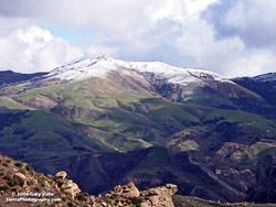 Snow on Oat Mountain (3747') 02/19/06 |
A Little Rain, a Little Snow.
La Niña Starting to Fade? What a difference a week makes! Last Sunday high temperatures around the Los Angeles area were in the mid-eighties, with t-shirt and shorts weather in the mountains. Following a rainy Saturday night, this Sunday dawned partly cloudy and cool, with a dusting of snow atop the higher foothills, and several inches in the mountains. |
Snow levels didn't drop quite as far as expected, but peaks such as Oat Mountain (3747'), north of Chatsworth, did receive a little snow. According to a statement issued by the National Weather Service Los Angeles/Oxnard, Wrightwood (5600') received 3-6 inches of snow, Newcombs Ranch (6000') and Mt. Baldy (7800') received 9-10 inches, Mountain High (6600-8000') 6-10 inches, and Mt. Pinos (8800') 3-6 inches. Further to the north, in San Luis Obispo County, Atascadero (1500-2000') received an inch of snow. A spectacular Southern California Sunday with a wintry edge. Our streak of rainless days ended Friday at 33 days when 0.19 inch of rain was recorded at Los Angeles (USC). Rainfall totals for the storm, including Friday's rainfall, generally ranged from about 0.3 to 0.7 inch, with Los Angeles (USC) recording 0.38 inch. That brings the water year total for Los Angeles to 5.33 inches, which is 4.3 inches below normal. Could La Niña already be starting to wane? Comparison of TAO/TRITON 5-day averaged Pacific equatorial SSTs and anomalies for the beginning of the month, and for yesterday, show significant warming in the eastern equatorial Pacific and in the area from about 160°W to 140°W. We'll see! More information concerning Southern
California weather can be found using our WEATHER
LINKS page. |
|
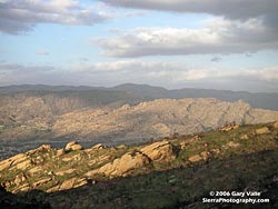 Clouds Over Simi Hills and Santa Susana Mountains 02/15/06 |
Winter Returns. Temperatures
Drop, Chance of Rain... and Snow. Monday, Los Angeles (USC) recorded a high temperature of 86°F. Yesterday the high was only 61°F, a drop of 25°F over two days. Winter, such as it is, has returned to Southern California. |
Accompanying the return of cool temperatures is a chance of rain, and a chance of ending our streak of rainless days at 33 or 34 days. The last measurable rain at Los Angeles (USC) was 0.10 inch on January 14. The NWS climate report for Los Angeles (USC) for February 15 indicates that we've had 4.95 inches of rain since July1, which is 4.14 inches below normal. Last year 25.16 inches of rain had been recorded by this date. What about the rain? Highly amplified flow has carved out a broad upper trough along the west coast. Lobes of vorticity are forecast to rotate through the trough and into Central and Southern California. The NAM has been wetter with the system than the GFS. The NAM forecasts a weak impulse to move through the area Friday night, and then forecasts another stronger area of vorticity to affect the area Saturday afternoon and evening. Based on today's model runs and other guidance, it looks like we could get anywhere from 0.1 to 0.5 inch in the coastal areas and valleys, with up to an inch or so in some foothill and mountain locations. Some of that will be snow, and with cool air already in place, and lowering thickness, snow levels could drop into the neighborhood of 3000-3500 ft. We'll see! Update 02/18/06 8:00 P.M. 00z NAM much drier than earlier runs, generating only about 0.2 inch of precipitation overnight and into tomorrow afternoon. Even so, convection could still produce a localized heavy shower or thunderstorm. Update 02/18/06 10:00 A.M. GFS and NAM computer models still disagree. Based on yesterday's rainfall amounts, you would have to give the edge to the NAM. This morning's 12z GFS produces less than 0.1 inch of rain at Van Nuys over the next 36 hours, while the NAM produces about 0.5 inch. The NAM has shifted the time of maximum precipitation to Sunday morning, but convection could produce showers, or a localized heavy shower or thunderstorm just about anytime between now and late Sunday afternoon. Snow levels are expected to be around 3000-3500 ft. with the possibility of snow showers locally down to 2500 ft. or lower. Update 02/17/06 10:00 A.M. 12z model runs still at odds with NAM generating a total of about 0.6 inch of rain at Van Nuys, and the GFS forecasting only about 0.25 inch. Here's a BUFKIT analysis of the 12z NAM data showing forecast precipitation and temperatures. Keep in mind that this is just the NAM's projection of what will occur. In reality, timing and other details will likely differ from what has been forecast. If you like wintry weather, Sunday could be spectacular, with decreasing clouds, cool temperatures, and snow on the mountains and foothills! More information concerning Southern
California weather can be found using our WEATHER
LINKS page. |
|
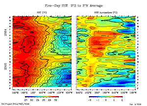 TAO/TRITON Section Plot 02/04/06 Equatorial 5-day averaged SSTs and anomalies. |
It's Official: La Niña
is Back. Los Angeles Rainfall Below Normal. |
In keeping with the return of La Niña, it's been a while since we've had measurable rain at downtown Los Angeles, and it looks like it's going to be a while longer. As of today, we've gone 21 days without rain, and model forecasts suggest the dry period could extend beyond 30 days. Yesterday's NWS climate report for Los Angeles (USC) shows that we've had 4.95 inches of rain since July1, which is 2.56 inches below normal. Last year, over the same period, 22.85 inches of rain had been recorded. More information concerning Southern
California weather can be found using our WEATHER
LINKS page. |
|