
NOTES ABOUT SOUTHERN CALIFORNIA WEATHER & CLIMATE
© 2000-2024 Gary Valle'. All Rights Reserved.
|
NOTES ABOUT SOUTHERN CALIFORNIA WEATHER & CLIMATE © 2000-2024 Gary Valle'. All Rights Reserved. |
IMPORTANT!! The
information presented on this web site may include errors of transcription,
interpretation, and other errors. The information may be out of date or
inaccurate. Please refer to the NATIONAL WEATHER SERVICE FORECAST OFFICE
LOS ANGELES or your local weather service office for official
forecasts and warnings. |
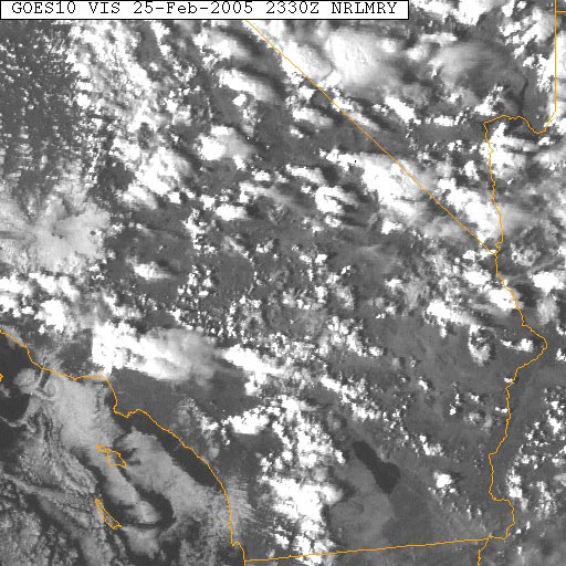 NRL GOES-10 Visible Satellite Photo 02/25/05 23:30z 3:30 pm PST |
Weathernotes for Friday, February 25, 2005(Any updates will be found at the end of this discussion.) Scattered showers and thunderstorms developed throughout much of the southwest this afternoon in moist unstable air associated with a broad area anti-cyclonic circulation centered over the Four Corners area. This counter-clockwise flow is what is left of the strong upper low that was off our coast earlier in the week. So it is still not done with us. A strong thunderstorm that developed in the San Fernando Valley, can easily be seen on this GOES-10 visible satellite photo from the Naval Research Laboratory (NRL). |
Following are links to archived copies of NWS Public Information Statements providing preliminary rainfall totals and additional information related to our February 17-23 heavy rainfall event. In our 02/23/05 update of Weathernotes we reported that according to COE data, OPIDS Camp had recorded a cumulative seasonal precipitation total of 107 inches. Today's Los Angeles Times has a good article about Opids Camp and its history. See When It Rains in L.A., It Pours at Opids Camp. Recent runs of the ETA (NAM), GFS and ECMWF suggest a more northerly track for the next system to move into California, with only a chance of rain south of Pt. Conception Monday into Tuesday. The GFS shows a ridge building into the area later next week, and today's NWS 8-14 Day Precipitation Outlook for Southern California has flip-flopped to "Below Normal." The Climate Prediction Center Precipitation Outlook issued February 17, 2005 indicates a better than 50/50 chance that rainfall in Southern California will be above average in March. We'll see! More information concerning Southern California weather can be found using our WEATHER LINKS page. |
|
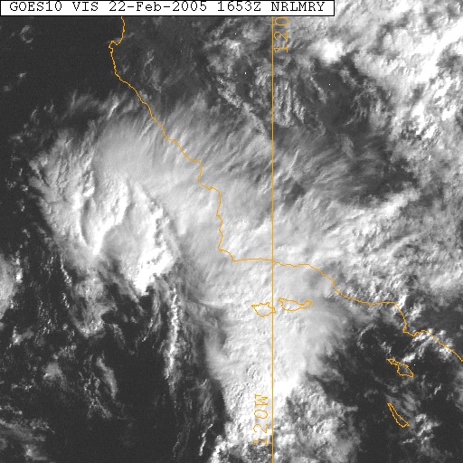 NRL GOES-10 Visible Satellite Photo 02/22/05 16:53z 8:53 am PST |
Weathernotes for Tuesday, February 22, 2005(Any updates will be found at the end of this discussion.) Upper level low currently west of Pt. Conception isn't done with us yet. The !2z NAM (ETA) forecasts the low to move slowly down the coast into Southern California over the next 24 hours, bringing with it the potential for severe weather, including very heavy rain, hail, gusty winds, waterspouts and even the possibility of small tornadoes. |
As of 6:00 this morning Los Angeles (USC) has received 7.61 inches of rain as a result of this latest "heavy rain event", increasing the 2004-2005 seasonal total to 32.87 inches -- the fourth wettest rainy season on record. By the time the upper low moves east out of our area, it is very possible the rainfall total at Los Angeles will rank it the third wettest on record, surpassing 1977-78, and (listening to the heavy rain outside) it could rank number two! When will the wet weather end? As far as the current rain event is concerned, both the 12z NAM (ETA) and the 12z GFS indicate the rain should taper off in the Los Angeles basin overnight tonight (Tuesday) into Wednesday. However the upper low is forecast to move east slowly and isolated residual showers could occur in some areas, especially east and south of the basin, through Thursday. The current NWS 6-10 day and 8-14 day Outlooks call for above average precipitation in Southern California. The Climate Prediction Center Precipitation Outlook issued February 17, 2005 indicates a better than 50/50 chance that rainfall in Southern California will be above average in March. We'll see! Update 02/24/05 7:00 A.M. Following are links to archived copies of NWS Public Information Statements providing preliminary rainfall totals and additional information related to the February 17-23 heavy rainfall event. Last few runs of the GFS have taken the next system more to the north, with the bulk of the precipitation falling north of Pt. Conception. The ECMWF has a similar solution, so maybe we'll see a "drier than expected" start to next week! Update 02/23/05 10:00 A.M. As of 6:00 A.M. this morning the rainfall total for the 2004-05 water year at Los Angeles (USC) was 33.87 inches, ranking the season the 3rd wettest on record, surpassing 1977-78. It is interesting to note that 1977-78 also experienced a central Pacific El Niño similar to this Winter's weak El Niño. (See the discussion on Klaus Wolter's MEI page.) Since last Thursday Los Angeles (USC) has received more than 9 inches of rain and OPIDS Camp, in the San Gabriel mountains, more than 22 inches. According to COE data, OPIDS Camp has recorded a cumulative seasonal precipitation total of 107 inches. 12z GFS forecasts about an inch of rain from early Sunday morning through Tuesday evening, but we'll have to see how things develop and what higher resolution models say about the system. More information concerning Southern California weather can be found using our WEATHER LINKS page. |
|
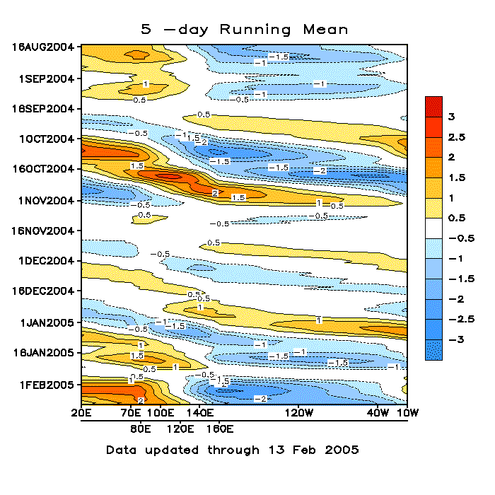 CPC Madden-Julian Oscillation Indices 02/13/05 |
Weathernotes for Monday, February 14, 2005(Any updates will be found at the end of this discussion.) Significant differences persist in the 12z NAM (ETA) and GFS model solutions for this week's weather in Southern California. Basically the ETA is dry and the GFS wet. The culprit is an upper level low off the California coast. The 12z ETA holds off on any precipitation at Los Angeles until Thursday afternoon, while the 12z GFS solution shows rain beginning Tuesday mid-day. |
This stitched multi-satellite IR image of the Pacific basin shows the upper low off the California coast, with a long fetch of moisture extending to an area of enhanced convection near the date line. This area of convection is associated with the Madden-Julian Oscillation. In some circumstances MJO activity near the dateline can result in heavy precipitation events in the West. This appears to have been the case with the October 16-20, 2004 heavy precipitation event in California. At the moment, neither the 12z GFS or the 12z ECMWF develop the split flow phasing and full latitude trough described in the typical scenario on the CPC's MJO FAQ page. Whether the current pattern evolves into an MJO linked precipitation event or not, it appears California may be impacted by an extended period of wet weather. The current NWS 6-10 Day Outlook calls for above average precipitation in California. We'll see! Update 02/21/05 8:30 A.M. As of 8:00 A.M. this morning the rainfall total for the 2004-05 water year at Los Angeles (USC) was 31.36 inches, ranking the season the 5th wettest on record, surpassing the big El Niño winters of 1982-83 and 1997-98. Since last Thursday Los Angeles (USC) has received more than 6.5 inches of rain and OPIDS Camp, in the San Gabriel mountains, more than 17 inches. Update 02/19/05 10:00 A.M. The rainfall total for the water year at Los Angeles (USC) now exceeds 27 inches, ranking the season the 9th wettest on record. With 4.5 inches of additional rain forecast through Tuesday afternoon by the 12z NAM (ETA) at Los Angeles, it appears likely the 2004-2005 rainy season will displace the "winter of '69" as the 7th rainiest water year on record. The Climate Prediction Center Precipitation Outlook issued February 17, 2005 indicates a better than 50/50 chance that rainfall in Southern California will be above average in March. Update 02/18/05 10:00 A.M. Some fairly strong embedded cells resulting in heavy rain in some areas of Southern California this morning. 12z NAM (ETA) is forecasting more than 5 inches of rain at Los Angeles from early this morning (Friday) through Monday afternoon. Update 02/16/05 7:30 P.M. The behavior of cut off upper level lows can be notoriously difficult to forecast. To this point, the NAM (ETA )seems to have had a better grasp of the situation. That's a little worrisome because the 02/17/05 00z NAM (ETA) is forecasting more than 3 inches of rain at Los Angeles after midnight Thursday to early Sunday morning. Over the same period the 18z GFS forecasts a little more than an inch of precipitation. The GFS is also a few hours earlier with the onset of the rain. Update 02/15/05 9:00 A.M. 12z NAM (ETA) is still much drier through mid-day Friday than the 12z GFS. A NOAA (ARL) meteogram based on 12z GFSx data indicates a total of 2.6 inches of rain for Los Angeles through Sunday evening. The 12z GFS forecasts a period of very light rain starting later today and ending tomorrow (Wednesday) morning, with more significant rainfall picking up again Thursday morning. More information concerning Southern California weather can be found using our WEATHER LINKS page. |
|
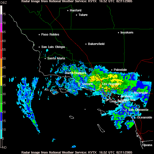 NWS Sulphur Mountain Composite Radar 02/11/05 1652z 8:52 am PST |
Weathernotes for Friday, February 11, 2005(Any updates will be found at the end of this discussion.) NWS Sulphur Mountain Composite Radar from 8:52 this morning shows echoes indicative of moderate to fairly heavy rain in areas of Los Angeles and Ventura counties. This morning, recorded rainfall totals for this storm generally range from about one to two inches. OPIDS Camp near Mt. Wilson has recorded about three inches. The rain is the result of an upper level low, currently west of San Diego, and it's associated atmospheric features. These include a fetch of sub-tropical moisture with high precipitable water values, some vorticity advection, some difluence, and some divergence resulting from a 120+ knot jet max nosing into Baja and southern Arizona.
|
Yesterday's NAM (formerly ETA) forecast about 2 inches of rain at Los Angeles from this system. As of about 10:00 a.m., downtown Los Angeles (USC) has received about 1.4 inches of rain. Additional rain is expected today and tonight. An ARL compilation of 18z NAM data generates about 2 inches of additional rain at Los Angeles through mid-morning Saturday. A BUFKIT analysis of 12z NAM data for Van Nuys generates about 1.5 inches for the same period. Medium range models have been generally consistent in forecasting the development of an upper level low off the California coast late Sunday or early Monday and keeping it there through the weekend. Today's 12z GFS only forecasts about an inch of rain from early Tuesday morning through Friday afternoon, but the pattern is complex, and precipitation amounts forecast this far in advance should be considered very speculative. We'll see! Update 02/12/05 9:00 A.M. Downtown Los Angeles (USC) set a new record for the date yesterday, recording 2.12 inches of rain. The old record was 1.63 inches, set in 1973. This brings the water year total for Los Angeles to 24.99 inches, 16.44 inches above normal. Last year on this date the water year total was 3.89 inches. Storm totals from this latest system have generally ranged from about one to three inches. OPIDS Camp has recorded just over 6 inches. Today's 12z GFS generates about 2 inches of rain at Los Angeles from mid-morning Tuesday through early Saturday morning. More information concerning Southern California weather can be found using our WEATHER LINKS page. |
|
