NOTES ABOUT SOUTHERN CALIFORNIA WEATHER & CLIMATE
© 2000-2024 Gary Valle'. All Rights Reserved.
|
NOTES ABOUT SOUTHERN CALIFORNIA WEATHER & CLIMATE © 2000-2024 Gary Valle'. All Rights Reserved. |
IMPORTANT!! The
information presented on this web site may include errors of transcription,
interpretation, and other errors. The information may be out of date or
inaccurate. Please refer to the NATIONAL WEATHER SERVICE FORECAST OFFICE
LOS ANGELES or your local weather service office for official
forecasts and warnings. |
Previous Month - Index - Next Month
|
Another Difficult Forecast. |
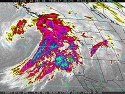
This morning's 12z NAM and GFS aren't generating much in the way of rainfall in the Los Angeles area from the system. The 12z NAM is projecting a mere 0.02 inch at Van Nuys and the GFS not much more. A BUFKIT analysis of the 12/26/06 00z GFS appeared to be a little more realistic, projecting about 0.1 inch at Van Nuys. Looking at a GOES-11 IR satellite image from this morning, and other guidance, it sure seems there is at least the potential for more rain than what the models are projecting. This time there should be ample moisture, but the atmospheric dynamics that effectively turn the moisture into rain are forecast to remain north of the area. With precipitable water values of over an 1.0 inch forecast, it wouldn't take much lifting to produce more than 0.1 inch of rain. We'll see! Update 12/27/06 9:30 A.M. A fast moving cold front, energized by favorable jet dynamics, produced bands of thunderstorms that swept through Santa Barbara, Ventura and portions of Los Angeles counties overnight, resulting in heavy rain in some areas. In the areas affected by the thunderstorms rainfall amounts generally ranged from about 0.12 inch to about 0.50 inch. For the 24 hr. period ending 9:00 a.m., the CNRFC Observed Precipitation Map indicates that Downtown Los Angeles (USC) recorded 0.20 inches of rain. More information concerning Southern
California weather can be found using our WEATHER
LINKS page. |
|
|
Difficult Forecast for the
Weekend. |
Yesterday's 12z NAM and GFS were nearly dry. This morning's 12z NAM generates only about 0.15 inch at Los Angeles and the 12z GFS is almost dry. The 09z SREF ensemble forecast puts the probability of more than 0.1 inch of rain in the Los Angeles area over the 24 hr. period ending Sunday night at less than 30%, and only increases the probability to about 50% for more than 0.01 inch. The SREF plots also suggest the probability of precipitation is somewhat higher to the north and south of the Los Angeles area. Despite the computer model's pessimistic projections , it sure seems that there is at least the potential for a little more rain than is currently forecast. The trough looks relatively strong, with good dynamics. All it needs is a little more moisture. We'll see! The 2006-2007 El Niño has continued to strengthen. Dr. Klaus Wolter's Multivariate ENSO Index (MEI) for October/November increased from 1.03 to 1.29. This moves the MEI above the strong El Niño threshold, as defined by the index. It is the 5th highest MEI for all October-November values (since 1950). and is the highest ranked value since April-May 1998. The ENSO Diagnostic Discussion issued December 7 by the CPC/NCEP projects that El Niño conditions are likely to continue through May 2007. Update 12/16/06 8:30 A.M. This morning's 12z runs of the NAM and GFS are a little wetter than yesterday's runs, and appear to be converging on solutions that project about 0.2 inch of rain at Los Angeles, with somewhat higher amounts in the mountains and to the south of Los Angeles county. More information concerning Southern
California weather can be found using our WEATHER
LINKS page. |
|
|
Change to More Seasonable
Pattern? MEI Exceeds Strong El Niño Threshold. |
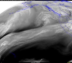
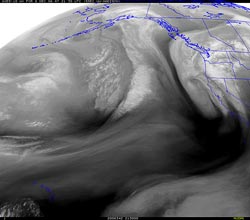
Today's 18z NAM and GFS are in pretty good agreement regarding the system forecast to move into the area Saturday afternoon, projecting about 0.3 inch of precipitation at Los Angeles. The models indicate that most of the precipitation should end by Sunday morning, but suggest a slight chance of a shower Sunday afternoon. Saturday evening's system looks pretty impressive in this UW-MAD processed GOES-10 satellite water vapor image. BUFKIT analysis of 12z NAM and GFS data project south-southwest winds of about 25-30 kts at the 5,000 to 8000 ft. level Saturday night, and the 18z NAM depicts a favorably positioned 100 kt. jet max overhead in this same time frame. Maximum precipitable water values are projected to be around 0.8 inch. Should this system find a better moisture connection, and move more slowly through the area, currently forecast rainfall amounts could be understated. We'll see! The 2006-2007 El Niño has continued to strengthen. Dr. Klaus Wolter's Multivariate ENSO Index (MEI) for October/November increased from 1.03 to 1.29. This moves the MEI above the strong El Niño threshold, as defined by the index. It is the 5th highest MEI for all October-November values (since 1950). and is the highest ranked value since April-May 1998. The ENSO Diagnostic Discussion issued December 7 by the CPC/NCEP projects that El Niño conditions are likely to continue through May 2007. Update 12/10/06 3:00 P.M. Intellicast composite radar shows last night's wet system as it was moving through the Los Angeles area. The fast moving shortwave trough and front produced rain rates in some areas of 0.3 inch/hr. or more. Rainfall totals in the Los Angeles area generally ranged from about 0.3 to 0.5 inch with somewhat higher totals in Ventura and Santa Barbara counties. The favorably aligned Santa Barbara coastal mountains recorded totals of about 1 inch. Update 12/09/06 8:00 A.M. 12z NAM and GFS have backed off a bit on precipitation amounts for the incoming system, projecting between 0.25 and 0.33 inch of rain at Los Angeles. The 09z SREF ensembles peg the probability of more than 0.1 inch of rain in the Los Angeles area over the next 24 hours at 70% or better, but indicate a probability of only about 30% for more than 0.25 inch of rain. BUFKIT analysis of 12z NAM data still shows fairly strong south-southwest inflow associated with the system, so south to west facing foothill and mountain slopes should see higher precipitation totals due to orographic enhancement. More information concerning Southern
California weather can be found using our WEATHER
LINKS page. |
|
or Press your Browser's BACK button.