
NOTES ABOUT SOUTHERN CALIFORNIA WEATHER & CLIMATE
© 2000-2024 Gary Valle'. All Rights Reserved.
|
NOTES ABOUT SOUTHERN CALIFORNIA WEATHER & CLIMATE © 2000-2024 Gary Valle'. All Rights Reserved. |
IMPORTANT!! The
information presented on this web site may include errors of transcription,
interpretation, and other errors. The information may be out of date or
inaccurate. Please refer to the NATIONAL WEATHER SERVICE FORECAST OFFICE
LOS ANGELES or your local weather service office for official
forecasts and warnings. |
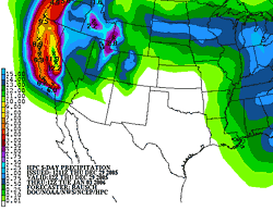 HPC 5-day Precipitation Forecast Issued 12/29/05 12:11z 4:11 AM PST |
Back to Back Storms Bring
in the New Year. Rain Forecast for Rose Parade. |
At the moment, the GFS computer model is forecasting two periods of precipitation for Southern California. The first, on Saturday, looks to be just a precursor to what could be a major rain event Sunday into Monday. On Saturday, the 18z NAM generates about 0.4 inch of rain at Los Angeles, beginning in the morning and ending in the evening. After that all eyes turn to the West as a long fetch of Pacific moisture and jet energy takes aim at Southern California. Given the ample supply of moisture and the jet energy involved, timing of the systems, rainfall amounts, and other details of the forecast may change. The potential exists for heavy rain with above normal runoff and possible mudslides or debris flows, particularly in or near areas that have been recently burned. Update Sunday, 01/01/06 3:00 P.M. Los Angeles (USC) recorded 0.88" of rain December 31st from system #1. Some rainfall amounts recorded around the area were 0.57" at the Cheseboro RAWS in the Topanga burn area; 1.96" at the Malibu Hills RAWS; 1.19" at El Monte; 0.59" at Corona del Mar. System #2 looks very impressive on IR satellite this afternoon and is already producing moderate to heavy rainfall in many areas. A BUFKIT analysis of 18z NAM data generates about 5 inches of rainfall in the central San Fernando Valley over the 24 hour period ending at 4:00 P.M. tomorrow (Monday). We'll see! More information concerning Southern
California weather can be found using our WEATHER
LINKS page. |
|
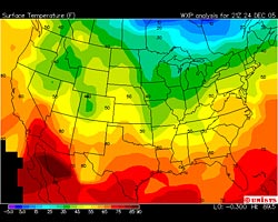 Unisys Weather Temperature Contour Plot From 12/24/05 21:00z 1:00 PM PST |
Eighty Degrees the Day Before
Christmas; Chance of Rain the Day After. |
Cooler temperatures are expected in the Los Angeles area on Christmas Day with areas of fog in the morning, especially near the coast. Clouds should be increasing Sunday afternoon and evening leading to a chance of rain on Monday. The 18z NAM and GFS computer models both produce about a 0.25 inch of rain at Los Angeles on Monday. Higher amounts would be expected in favored foothill and mountain locations. We'll see... Happy Holidays! Update Sunday, 12/25/05 10:00 A.M. 12z NAM and GFS model runs have really backed off on rainfall amounts south of Pt. Conception for Monday, generating little more than drizzle or very light rain in the Los Angeles area. The 09z SREF ensembles put the chance of more than 0.01 inch of rain at about 50%, but the chance of more than 0.1 inch is 10% or less. More information concerning Southern
California weather can be found using our WEATHER
LINKS page. |
|
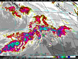 GOES-10 IR Satellite Image From 12/01/05 18:30z 10:30 AM PST |
Jet Max Expected to Enhance
Sierra Snow. |
HPC Day 1 precipitation forecast issued 1800z has a point max of about 3.6 inches (water equivalent) in Central Sierra. A BUFKIT analysis of 18Z NAM data for C01, near Evolution Valley, generates about 4.7 inches of precipitation in about the same area. While high precipitable water values are forecast in Southern California as the axis of the moist inflow shifts south tomorrow, computer models indicate weak dynamics in our area with the 18z NAM generating only 0.15 inch of precipitation at Los Angeles. Higher amounts are forecast in some orographically favored foothill and mountain locations, especially north of Pt. Conception. Except for the possibility of some isolated residual showers in the mountains early Saturday morning, no additional rain is currently forecast over the weekend. Klaus Wolter's Multivariate ENSO Index (MEI) for Sep/Oct dropped below -0.2 for the first time since Oct/Nov 2001. According to Dr. Wolter, "the recent drop into negative values shows that this is not a 'normal' year, and a further drop into true La Niña conditions appears possible." As of November 23, 2005, negative SST anomalies existed in the Nino 1+2, Nino 3 and Nino 3.4 regions. In their ENSO Wrap-Up the Australian Bureau of Meteorology reports the "pattern is neutral to borderline cold." Interestingly, the SOI dropped from +11 to -4. Update Friday, 12/02/05 4:00 P.M. Front is pretty much "dying on the vine" the way models said it would. Rainfall totals decrease dramatically north to south from around 1.3 inches at San Luis Obispo, to 0.5 inch at Santa Barbara, to about 0.16 at Oxnard, to 0.0 at Los Angeles (USC). Update Friday, 12/02/05 7:00 A.M. Intellicast.com composite radar for 7:00 a.m. shows front holding together as it passes Pt. Conception. This may be due in part to divergence associated with the right rear quadrant of 110 kt. jet max, shown in the 15z forecast of the NCEP HiResW. As of 6:00 a.m. most of the rainfall from this system has been north of Pt. Conception. The HiResW forecast 250mb level wind forecast for 18z (10:00 a.m. PST) shows another 100 kt. jet max developing overhead. If accurate, this may increase lift along the front and increase rainfall totals south of Pt. Conception over those currently projected. More information concerning Southern
California weather can be found using our WEATHER
LINKS page. |
|
