NOTES ABOUT SOUTHERN CALIFORNIA WEATHER & CLIMATE
© 2000-2024 Gary Valle'. All Rights Reserved.
|
NOTES ABOUT SOUTHERN CALIFORNIA WEATHER & CLIMATE © 2000-2024 Gary Valle'. All Rights Reserved. |
IMPORTANT!! The
information presented on this web site may include errors of transcription,
interpretation, and other errors. The information may be out of date or
inaccurate. Please refer to the NATIONAL WEATHER SERVICE FORECAST OFFICE
LOS ANGELES or your local weather service office for official
forecasts and warnings. |
Previous Month - Index - Next Month
|
Neverending Cool Pattern Continues.
Chance of Showers and Thunderstorms in Southern California. La
Niña Wanes. Back in mid-April, a couple of GFS model runs suggested the continuing cavalcade of upper level lows and troughs that has been producing unseasonably cool weather in much of California might shift to a more April-like pattern and frequency. No go! |
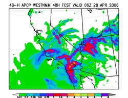
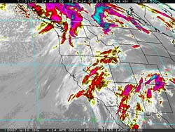
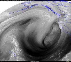
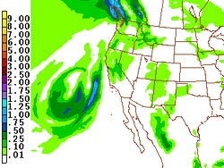
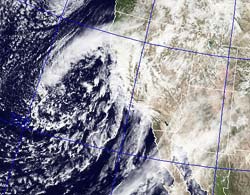
Climate reports for Los Angeles (USC) show that so far this April, the average daily temperature has been below normal 21 of 25 days. Including the data for March, 49 out of the last 56 days have been cooler than normal. These graphics from the CPC show the mean temperature and anomaly for the contiguous U.S. over the last 30 days and 90 days. On the precipitation side, since 0.21 inch was recorded on April 14, Los Angeles (USC) has recorded an additional 0.02 inch on April 22, and 0.01 inch on April 23. This brings the seasonal total at Los Angeles, as of yesterday, to 12.34 inches, which is 2.38 inches below normal. Another upper level low, the latest in our series of upper level lows, is spinning off the coast of Southern California this morning, and producing showers and thunderstorms to the north of Pt, Conception and in the San Joaquin Valley. The Vaisala Lightning Explorer® shows lightning occurring in those areas. The 12z NAM forecasts the low to track southeastward to the California-Mexico border over the next 24 hours, bringing with it, the possibility of showers and thundershowers over much of Southern California. The HIRESW NMM from 06z projects precipitation totals of as much as 1.0 to 2.0 inches, or more, in some areas of the Southland from this system, but less than 0.1 inch in the area of the Los Angeles basin. A GOES-10 sounding from 12z this morning near the center of the low indicated a 500 mb temperature of -25°C and precipitable water values on the order of 0.7 inches. Given the cold air aloft and moisture associated with the system, a heavy shower or thunderstorm could crop up just about anywhere in Southern California today, including the Los Angeles basin. We'll see! While our weather has been usually cool, temperatures in the equatorial Pacific have warmed somewhat in recent weeks, appearing to end this Winter's brief La Niña. According to the April 18th IRI ENSO update, neutral conditions have returned and "Based on the latest observations and forecasts, the probability of neutral conditions continuing through the Apr-May-June 2006 season is approximately 80%." This TAO-TRITION graphic shows the depth-averaged equatorial ocean temperature and anomaly for the 5-day period ending April 25, 2006. Update 04/28/06 12:00 P.M. A trace, but no measurable rain, was recorded at Downtown Los Angeles (USC) on the 26th and 27th of April. The highest rainfall amounts for the two day period were generally recorded in San Luis Obispo and Santa Barbara counties, where totals ranged from less than 0.1 inch to over 0.5 inch. Santa Maria Airport recorded 0.87 inch over the two days. More information concerning Southern
California weather can be found using our WEATHER
LINKS page. |
|
|
More Seasonable Weather Forecast
for Southern California. Remember the weather just before Valentine's Day? On February 13th Los Angeles (USC) recorded a high temperature of 86 degrees. Just a week later it snowed in the foothills, and it seems like it's been cool with showers or rain every few days ever since. |
Friday's upper level low and front behaved more or less as forecast. Recorded rainfall totals generally ranging from about 0.25 to 0.5 inches, with a few locations reporting an inch or more. Here's a NCAR archived regional radar image from about 10:00 A.M. Friday morning showing the precipitation associated with the system as it moved onshore. In the past 24 hours, another trough and weakening front has resulted in some light measurable rain to the north and west of the Los Angeles basin. There was even a little light rain on the north side of the Grapevine this morning. Today's 18z GFS forecast shows the parade of west coast troughs and lows continuing over the next week or two, but more as inside sliders, with less of a chance of significant precipitation in our area. The forecast suggests more seasonable weather. We'll see! More information concerning Southern
California weather can be found using our WEATHER
LINKS page. |
|
|
Rain Forecast for Friday. GOES-10 water vapor image show huge upper level low over the eastern Pacific with quasi-stationary frontal zone impacting the Monterey and San Francisco areas, northward. RAMDIS shows the center of circulation more or less stationary, with the low continuing to extend southward, and some eastward movement of the frontal boundary. Intellicast.com composite radar from 2:15 PDT shows the extent of the precipitation. |
NAM and GFS models generally agree on the handling of the low, and both bring it onshore and over the Los Angeles area Friday morning. The 12z NAM, 12z GFS and 18z NAM all forecast about 0.5 inch of rain at Los Angeles. As the low gets kicked out by the circulation around the next low upstream, our low fills and weakens and moves out of the area by Friday evening. With the usual caveat regarding the behavior of cut-off lows, we'll see! More information concerning Southern
California weather can be found using our WEATHER
LINKS page. |
|
|
Chance of a Shower Over Next
24 Hours. Chance of Rain Friday? SREF (09z NCEP/NOAA Short Range Ensemble Forecast) says... Over the 24 hr. period ending Tuesday morning at 11:00, it forecasts an approximately 80%-90% chance of more than 0.01 inch of rain in the Los Angeles area, but a 10% chance, or less, of more than 0.1 inch. We'll see! |
Intellicast.com composite radar from 6:30 this morning shows a precipitation band associated with an embedded shortwave and persistent upper level trough along the coast of California. As the current trough moves onshore, it is replaced by yet another upper level trough and its associated surface low. The system is forecast to cut-off, and like most cut-off upper lows, creates a great deal of uncertainty in the forecast -- like when, where and how much precipitation? Initially models moved the system onshore in the Wednesday-Thursday timeframe, but recent model runs have kept the upper low offshore and moved it southward to west of San Diego, before lifting it northeast into Southern California at the end of the week. The 12z NAM forecast for Thursday afternoon at 5:00 shows the low well off the coast of Southern California. Cut-off lows seem to have a mind of their own, and their chaotic behavior is notoriously difficult to forecast. Small changes in the position of an upper level low can dramatically change the amount of precipitation forecast. At the moment, the 06z GFS is forecasting about 1.0 inch of rain at Los Angeles in the Friday into Saturday timeframe. The NWS Climate Report for April 9th reports Downtown Los Angeles (USC) has recorded 12.10 inches of rain since July 1, which is about 2.28 inches below normal. More information concerning Southern
California weather can be found using our WEATHER
LINKS page. |
|
|
Record Rain in Los Angeles
-- Record Snow at Mammoth Mountain! The strong Pacific low pressure system that has been spinning off the West coast since Sunday is finally moving onshore this morning. The late season low has been pumping copious amounts of sub-tropical moisture into the state, resulting in moderate to heavy rain in many areas, swollen rivers and creeks, and heavy snow at the higher elevations of the Sierra. |
According to preliminary NWS data, Downtown Los Angeles (USC) set a new rainfall record of 1.44 inches yesterday, breaking the record for the date set in 1921. This brought the water total at Los Angeles (since July 1) to 11.85 inches, which is still 2.31 inches below normal. Additional rainfall since midnight has further reduced this deficit. This image of clouds and rain in the Tehachapi Mountains near Grapevine was taken yesterday morning. Moderate to heavy rain extended from near Gorman all the way to the San Fernando Valley. This NRL visible IR satellite image from 10:00 A.M. yesterday shows what looks like a jet streak over the area. This, in addition to orographic lifting, may have enhanced rainfall during that time period. Rainfall totals around the Los Angeles area for the storm have generally ranged from about 1.00 inch to 2.50 inches. An Intellicast.com composite radar image from 11:15 A.M. today show numerous convective showers over the southern two-thirds of California. These showers are forecast to continue much of today, diminishing as the upper trough moves inland over the next 12 hours. The highest rainfall totals in Southern California have been recorded in the mountains of Santa Barbara and Ventura counties. Storm totals recorded in the Ventura River and Sespe Creek drainages have exceeded 6 inches of rain, and the resulting runoff dramatically increased the flow in these streams. Sespe Creek, a major tributary of the Santa Clara River, recorded a peak flow of about 29,000 cfs at Fillmore at 8:30 yesterday morning. With yesterday's 23 inches of snow Mammoth Mountain ski area has racked up an amazing 632 inches of cumulative snowfall, surpassing its previous seasonal record of 617 inches set during the 1992/93 season. That's over 52.5 FEET of snow. Much of Mammoth's terrain is above 9000 ft., so when the snow level is high and it's raining at other California ski areas, it often will be snowing at Mammoth. This has been the case several times this season. Check out this image from MammothMountain.com of a huge snowbank at the Stump Alley (Chair 2) parking area! Today's 12z GFS suggests the wet pattern may continue until about mid-month, with two more upper level troughs impacting California over the next 10 days. The first is forecast to affect primarily Northern and Central California this weekend, with only chance of showers south of Pt. Conception. The second system, which (at the moment) is forecast for mid-week next week, could be stronger and might bring rain to much of the state, including Southern California. We'll see! More information concerning Southern
California weather can be found using our WEATHER
LINKS page. |
|