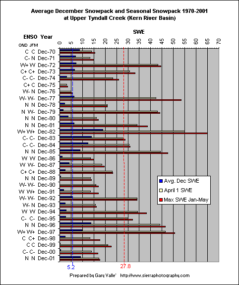
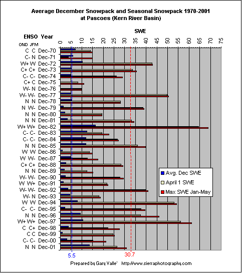
Early Season Snowpack and Seasonal Snowpack in the Upper Kern River Basin, 1970-2001Prepared by Gary Valle' Last update 10/15/2002. IntroductionDoes a below average snowpack in the Upper Kern River basin in December increase the likelihood of a below average seasonal snowpack? Examination of available data suggests this may be the case. The Upper Kern River (N.F. Kern River) has a drainage area at Kernville, California of about 1,000 sq. miles. It is one of the highest river basins in California, with Mt. Whitney, and several other 14,000 ft. peaks, within its boundaries. As a result of its high elevation, most of the runoff produced by the basin falls as snow. (Occasionally systems with a lower latitude origin and strong tropical connection will result in rain at high elevations of the basin.) Data SourcesThe daily revised snow water content from the Upper Tyndall Creek and Pascoes snow sensors was examined. These stations were selected because they are at a high enough elevation that most precipitation falls as snow, and they have the longest (1970-present) and most complete data records. The data was obtained from CDEC and has not been reviewed for accuracy. The record was relatively complete with few missing values. Missing values were interpolated, or in a very limited number of cases, estimated using snow survey data or other snow data. CalculationsFor each year, the mean December snow water equivalent (SWE) and a 7 day average SWE centered on April 1 was calculated. The maximum Jan-May SWE was determined, and Means were then computed for the December SWE and the maximum Jan-May SWE for the period of record. ResultsThe following chart shows the preliminary results for Upper Tyndall Creek. (The ENSO state for October, November and December (OND), and January, February and March (JFM) is also shown. This was taken from the Climate Prediction Center's Cold and Warm Episodes by Season.)
At Upper Tyndall Creek the mean December SWE was 5.2 inches (blue dashed line) and the mean seasonal maximum was 27.8 inches (red dashed line). Of 18 Decembers that had below average SWE, 15 (83%) had seasonal maxima that were below average. The average seasonal maximum in seasons with below average December SWE was 20.4 inches (73% of mean, SD 10.0). The average seasonal maximum in seasons with average or above average December SWE was 37.3 inches (134% of mean, SD 15.1). Is the observed reduction in snowfall due simply to December's contribution? To examine this question, the SWE on December 31 was subtracted from the seasonal maxima to produce an adjusted total. At Upper Tyndall Creek of 18 Decembers with below average SWE, 13 (72%) had adjusted totals that were below average. The average adjusted total in seasons with below average December SWE was 17.4 inches (86% of adjusted mean, SD 9.1). The average adjusted total in seasons with average or above average December SWE was 22.9 inches (116% of adjusted mean, SD 13.9). This suggests that the reduced seasonal total is due in part to December's contribution, and due in part to reduced snowfall after December. The results for Pascoes were also charted. The mean December SWE was 5.5 inches and the mean seasonal maximum was 30.7 inches. Of 21 Decembers that had below average SWE, 15 (71%) had seasonal maxima that were below average. The average seasonal maximum in seasons with below average December SWE was 26.6 inches (87% of mean, SD 10.7). The average seasonal maximum in seasons with average or above average December SWE was 38.5 inches (125% of mean, SD 18.2). CommentsFrom year to year the mean December and seasonal snowpack at Upper Tyndall Creek and Pascoes are extremely variable. Presumably this is because a small number of storms contribute significantly to the snowpack and any single storm may substantially increase the snowpack. Since the snowfall pattern is so variable, you wouldn't necessarily expect snowfall in December to be an indicator of seasonal snowfall. However, the difference in the average seasonal maximum SWE for seasons with below average December SWE and seasons with above average December SWE does appear to be statistically significant. Based on the historical data for Upper Tyndall Creek (UTY), if the average December snowpack is below normal, the maximum seasonal snowpack at UTY would be expected to be (95% Conf.) in the range of about 15.4 to 25.4 inches SWE. If the average December snowpack is above normal, the maximum seasonal snowpack at UTY would be expected to be in the range of about 28.5 to 46.0 inches SWE. At Pascoes the expected ranges would be about 21.8 to 31.5 inches SWE (below avg. Dec.) and 26.3 to 50.8 inches SWE (above avg. Dec.). If the data is normalized using a square-root transform the expected range for maximum seasonal snowpack at UTY is 14.1 to 24.8 inches SWE for below average Decembers and 26.4 to 43.6 inches for above average Decembers. |
