|
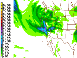

Forecast 24 hr. Precipitation (18z NAM 12/12/08)
10 PM Sunday to 10 PM Monday
|
It's been a couple of weeks since an upper level low set rainfall records for the date at several Southern California locations, and pushed water year rainfall totals above normal at Los Angeles. Since then we've had almost no rain, and as of yesterday, Downtown Los Angeles (USC) rainfall has dropped to about six-tenths of an inch below normal. If a storm later this weekend works out as expected, we could be back above normal by Monday night.
Several factors could affect the forecast. As we've seen earlier this season, the computer models don't do a particularly good job with high amplitude flows, retrograding ridges and digging troughs. Throw into the mix a strong 150-170 kt. jet stream, sub-tropical moisture being advected from Hawaii (nearly) to the Aleutians, and cold air being drawn down from Canada and Alaska, and there is the potential for high impact weather.
|
|
A chance of showers is forecast Saturday into Sunday, but at the moment, the main event is forecast for Sunday evening through Monday. HPC's QPF for that period indicates rainfall amounts ranging from about 0.75 inch to 2 inches or more in the mountains. We'll see!
More information concerning Southern California weather can be found using our WEATHER LINKS page.
|