|
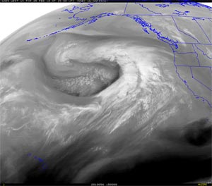

GOES-11 Water Vapor Image (UW-MAD)
February 25, 2010 - 7:00 a.m. PST
|
A weakening frontal band produced some light rain in Southern California yesterday afternoon and evening. Precipitation amounts in the Los Angeles area ranged from a trace to a few hundredths of an inch. Amounts were higher to the north, closer to the surface low. A few stations in Santa Barbara and San Luis Obispo counties recorded more than 0.5 inch and some recorded more than an inch. Here is an archived copy of a NWS Public Information Statement with some precipitation totals from around the area.
Today, a much stronger Pacific storm system begins to impact the West Coast, with the highest precipitation totals forecast for Northern California and the Sierra Nevada. BUFKIT analysis of this morning's 12z NAM data for Van Nuys generates about 1.3 inch of rain, beginning late Friday night and continuing into Saturday afternoon. The 18z NAM run starts the rain a little earlier Friday night, and extends the period of precipitation into Saturday evening. It produces about 1.8 inch of rain at Van Nuys over the period. Today's 09z SREF indicated a probability of about 50%-70% that precipitation in the Los Angeles area would exceed 0.5 inch for the 24 hr. period ending Saturday afternoon at 4:00 p.m. Precipitable water values approaching an inch and strong southerly low level inflow could produce higher rain rates and precipitation totals on south to southwest facing foothill and mountain slopes.
|
|
Since being reinforced by a strong MJO at the end of January, El Niño convection has remained active in the Central Pacific (animation). In terms of relative atmospheric angular momentum (AAM), the atmosphere's response is the strongest since the El Ninos of 1997-1998 and 2004-2005. Average AAM for our rain season (November to date) has increased from -0.046 at the beginning of the year to 0.341 as of February 23. This El Nino Comparison Chart shows how this El Niño compares to others since 1950.
So far this rain season, Downtown Los Angeles (USC) has recorded above average rainfall every month, except for November. And November's rain came early -- in October.
More information concerning Southern California weather can be found using our WEATHER LINKS page.
|