|
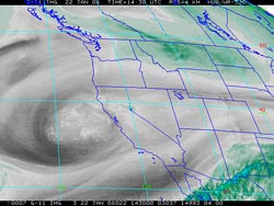

GOES-11 Water Vapor Image
January 22, 2008 6:30 a.m. PST
|
In a rain season characterized by upper level lows, yet another one has set up shop off the coast and has been sending some showers our way. As of 8:00 a.m. this morning rainfall totals around the Los Angeles area have generally ranged from a few hundredths of an inch to as much as about 0.25 inch in a few locations. Here is an archived copy of a NWS Public Information Statement with some preliminary rainfall totals.
As is often the case with this kind of scenario, the models have been having a difficult time handling the situation, and there has been a lot of variation from run to run. The 12z NAM and GFS remain at odds. The GFS is much wetter at Los Angeles through early morning Thursday, generating about 1.3 inches vs. the NAM's 0.5 inch. From early Thursday through Friday afternoon the NAM is a little wetter, generating 1.6 inches of rain at Los Angeles vs. the GFS's 1.2 inches.
|