|
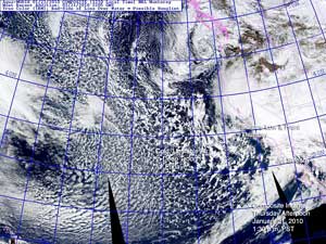

NRL AquaMODIS Composite Image
January 21, 2010 - 1:30 p.m. PST
|
The fifth and final system of the series that began Sunday brought thunderstorms, damaging winds, record low pressure, heavy rain and snow to Southern California yesterday. The unusually large trough associated with the system covered most of the northeastern Pacific yesterday, and unsettled weather is expected today as it continues to move onshore.
Very strong wings, possibly a tornado or thunderstorm downburst, felled trees and damaged structures in Ventura and Santa Barbara. Record rainfall for the date was recorded at Santa Maria, Palmdale, and Lancaster, but more extraordinary, new all-time records for lowest barometric pressure were set at several locations in the Los Angeles area. Note: The NWS documented an EF-0 tornado in Ventura (3Mb PDF).
Here are some preliminary rainfall totals from around the area, compiled by the NWS, for the period 10:00 p.m. Tuesday to 10:00 p.m. this evening. Note that this combines rainfall from system #4 on Wednesday, and our current Thursday-Friday system. And here's an NWS Public Information Statement with some impressive snowfall totals for the week. Wow -- Mt. Baldy got 7 feet of snow! (Updated 01/23/10)
|
|
As of yesterday, Downtown Los Angeles (USC) has received 4.21 inches of rain from the series of storms, bringing its water year total to 9.34 inches, which is 3.44 inches above normal. Over the week, the Sierra Nevada has received several feet of snow, and the statewide average snowpack is now above normal.
Please refer to www.weather.gov/losangeles for the latest warnings and weather information.
More information concerning Southern California weather can be found using our WEATHER LINKS page.
|