|
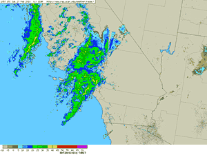

NEXRAD Regional Radar (NCAR)
February 27, 2010 - 3:00 a.m. PST
|
A
primary frontal band, secondary frontal band, and upper low associated with a strong Pacific storm system produced periods of heavy rain in Southern California on Saturday. Rainfall totals for the system generally ranged from about 1.0 to 2.0 inches, with somewhat higher amounts recorded at a few mountain locations. Here is an archived copy of a NWS Public Information Statement with some precipitation totals from around the area.
Downtown Los Angeles (USC) recorded 0.80 inch of rain for the storm, bringing the water year total (Jul 1-Jun 30) to 14.18 inches, which is 3.25 inches above normal. Saturday, Burbank set a new rainfall record for the date of 1.6 inches.
The weather forecast for the Los Angeles area this week looks like a near repeat of last week, with a chance of showers mid-week, and then a possibility of a somewhat stronger storm for the weekend.
|
|
Just 24 hours before a trough is forecast to produce a chance of showers in the Los Angeles area, the models are still having difficulty with the forecast. The nature of the system is the culprit -- the evolution of the trough and precise track of a following upper low is far from certain. Today's 09z SREF suggest a high probability (70%-90%) of very light rain (>0.01 inch) for the 24 hr. period ending 7:00 a.m. Wednesday morning, but south of Pt. Conception there is a rapid decrease of the probability of more than 0.1 inch of precipitation over the same period.
More information concerning Southern California weather can be found using our WEATHER LINKS page.
|