|
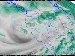

GOES-11 Water Vapor
Tuesday, March 4, 2009 2:30 p.m. PST
|
The precipitation total for Downtown Los Angeles (USC) for February was a little above normal, but not enough to offset January's dry weather. We started out March with a water year rainfall total about 2.4 inches below normal, and as of today we're about 2.73 inches behind.
Tuesday's frontal passages helped a little. Here's a GOES-11 water vapor image from 2:30 in the afternoon, and an Intellicast.com composite radar image from 2:45 p.m. Downtown Los Angeles (USC) recorded 0.25 inch of rain for the storm, and rainfall totals generally ranged from about 0.25 to 0.50 inch. Here is an archived copy of a NWS Public Information Statement listing some rainfall totals.
|
|
It looks like our rain season may not be over. Recent runs of the GFS have been hinting at some rain in the 8-10 day timeframe, with a series of systems following. This is consistent with Ed Berry's Atmospheric Insights post today. In response to increased subtropical westerly wind flow, he suggests the possibility of an extended East Asian jet in the week 2-3 timeframe, with possible western USA impacts. We'll see!
More information concerning Southern California weather can be found using our WEATHER LINKS page.
|