
AHPS Precipitation (Percent of Normal)
For 60 Days Ending November 22, 2010 at 4:00 a.m.
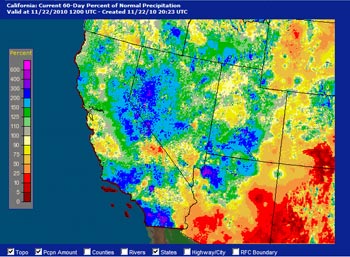
Saturday's front wasn't as strong as expected, but still produced some resepectable rainfall totals. Sunday's front was better defined and had better dynamics, but moved through the area relatively quickly. The end result is that water year precipitation totals remain near to above normal for many Southern California locales, and about 0.15 inch below normal for Downtown Los Angeles.
Precipitation totals varied widely. In the Los Angeles basin and surrounding valleys amounts generally ranged from about 0.25 inch to 1.0 inch. Foothill and mountain locations in Los Angeles county recorded about 1.0 to 2.0 inches, but several stations recorded over 2.0 inches. Tanbark in the San Gabriel Mountains recorded 3.51 inches, and Ortega Hill in the Ventura Mountains recorded 5.0 inches! Here's an archived copy of a NWS Los Angeles/Oxnard Public Information Statement with some precipitation totals from around the area.
A drier version of last weekend's system -- with a more inland track -- is forecast to produce more rain and snow in the northern two-thirds of California through midweek, but not much precipitation is expected in Southern California.
This morning's 09z SREF pegged the chance of more than 0.1 inch in coastal Southern California for the 24 hours ending 4:00 a.m. Wednesday at between 30% and 50%, and the chance of more than 0.01 inch at around 90%. The 00z 11/23/10 NAM forecast is slightly wetter south of Pt. Conception than the 18z NAM, but is still forecasting under 0.1 inch in most areas.
It was cold in Southern California last night with lows dipping into the 30's in many valley locations. Malibu Canyon recorded a low of 30°F. Cold overnight temperatures are exepected to continue through Thanksgiving.
More information concerning Southern California weather can be found using our WEATHER LINKS page.