Previous Page Page 2 of 2 in the LosAngelesTemperature category
# Friday, 20 June 2008

BUFKIT GFS 2-meter (red) and Skin (blue) Temperatures for VNY 06/20/08 12z Click!
BUFKIT GFS 2-meter (red) and Skin (blue) Temperatures
VNY 06/20/08 12z

Temperatures today at Los Angeles Pierce College in Woodland Hills appear to be running about a degree hotter than yesterday, when a new record high for the date of 109°F was recorded at the campus weather station.

A BUFKIT analysis of 12z data for Van Nuys shows temps peaking today at about 107°F, followed by a slow cooling trend into next week, with high temps dropping down into the high eighties. In this graph of temperatures, the red line is the 2-meter temperature and the blue line is the surface "skin" temperature.

Equatorial Pacific SSTs continue the transition to neutral conditions. This TAO section plot of 5-day Depth Average Temperature clearly shows the change in state with a marked increase in sub-surface temperatures, particularly in the far eastern and western equatorial Pacific.

It looks like Downtown Los Angeles (USC) will end the July 1, 2007 to June 30, 2008 water year with 13.53 inches of rain recorded. This is 91% of the 1921-2006 average of 14.87 inches.

Update Monday, June 23, 2008. On Friday, Los Angeles Pierce College in Woodland Hills eventually reached a record-setting high of 111°F! Here is an archived copy of a NWS Los Angeles/Oxnard Record Event Report listing record highs from around the area for Friday, June 20.

More information concerning Southern California weather can be found using our WEATHER LINKS page.

Friday, 20 June 2008 17:18:24 (Pacific Daylight Time, UTC-07:00)  #    Disclaimer  |   | 
# Saturday, 17 May 2008

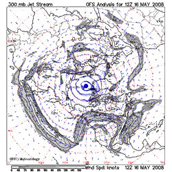
SFSU 300mb Jetstream Analysis - 5/16/08 12z Click!
SFSU 300mb Jetstream Analysis - 5/16/08 12z

Chance of a Shower Next Weekend?

An unseasonably strong and extended Pacific jetstream has resulted in a very high amplitude high pressure ridge over the West Coast with record and near record temperatures seen from Seattle to San Diego.

Yesterday, Woodland Hills set a new high temperature record for the date of 101°F. Record high temperatures were also recorded at Ojai, Sandberg, Santa Ana, El Cajon, Red Bluff, Redding, Sacramento, Stockton, Modesto, San Jose, Eureka and several other stations in California. Triple digit highs were recorded across much of the interior of the state.

It's hot again today, and will be hot again tomorrow, but the GFS, ECMWF and other guidance is suggesting that as the extended Pacific jet collapses, the west coast ridge will retrograde off the coast and be replaced by a trough by Memorial Day Weekend. This would result in cooler weather in California, and even the possibility of showers in some areas, such as the Sierra and our local mountains. We'll see!

More information concerning Southern California weather can be found using our WEATHER LINKS page.

Saturday, 17 May 2008 17:06:21 (Pacific Daylight Time, UTC-07:00)  #    Disclaimer  |   |