
NCAR NEXRAD Composite Regional Radar Image
Wednesday, April 25, 2012 at 9:57 pm PDT
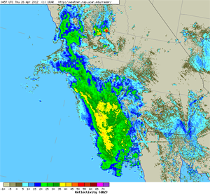
Judging from this NEXRAD regional composite radar image last week's system might have been much wetter. As has happened a couple of times this season, much of the heavier rain appears to have remained offshore. Even so, this compilation of rainfall totals from around the area by the NWS Los Angeles/Oxnard lists some respectable rainfall totals for a late season storm in Southern California.
Downtown Los Angeles (USC) recorded 0.49 inch for the storm, increasing April's rainfall total to 1.71 inches. This is almost double April's normal of 0.91 inches. The water year total rainfall for Downtown Los Angeles now stands at 8.68 inches; which is about 60% of normal at this point in the water year. The water year extends from July 1 to June 30.
In a "normal" season Los Angeles would be expected to record another 0.35 inch of rain by June 30. Both the 6-10 Day Precipitation Outlook and 8-14 Day Precipitation Outlook from the CPC are indicating a better chance of below normal precipitation in Southern California than of normal or above normal precipitation. The CPC Monthly and Three Monthly Temperature and Precipitation Outlooks are indicating an equal chance of above normal, normal, and below normal precipitation in Southern California. We'll see!
More information about Southern California weather and climate can be found using our WEATHER LINKS page.