|
|
West Fork San Gabriel RiverShortcut Cyn to Hwy 39 Bridge |
|
|
West Fork San Gabriel RiverShortcut Cyn to Hwy 39 Bridge |
| SUMMARY | |
| Location: |
Angeles National Forest, north of Los Angeles, California |
| Put-in: |
Silver Mocassin Trail at West Fork (3060') |
| Gradients: |
1) 168 2) 177 3) 103 4) 127
5) 100 6) lake 7) lake 8)
92 9) 100 10) 50 11) 55 12)
90 13) 85 14) 107 14.2) |
| Take-out: |
Bridge at Hwy 39 (1575') |
| NOTES | |
|
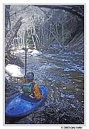
The West Fork San Gabriel River includes a stunning wild section above Cogswell Reservoir that winds it's way through a road-less and trail-less area of the San Gabriel Wilderness. It's easy to see why there are no trails. The river has carved a path through a fault fractured composite of granitic and metamorphosed rock. Steep, impassable cliffs intermittantly border the stream. In places escape on foot would be difficult, if not impossible. But this is the nature of mountain creeks and rivers. For the gracious kayaker, the river has done - and will do - most of the work. |
|
We paddled the West Fork on Sunday, March 16, 2003. During the preceding 24 hour period, Los Angeles (USC) set a rainfall record for the date of 4.1 inches. This was the second largest 24 hour March rainfall total on record. In the preceding 48 hours West Fork Heliport recorded 5.47 inches and Cogswell Dam recorded 5.75 inches of rain. The USGS Arroyo Seco gage peaked at 2.97 at 2:00 a.m. on March 16. The night before run, heavy rain pounded on the roof. I was sure we would have too much water. The thought of hiking down 3+ miles, just to turn around and hike up back to car haunted me. But, like Arroyo Seco, the West Fork requires a prodigious amount of rain to be boatable. As it turned out, the water level was nearly ideal. There was good coverage, but the level was not pushy. We even had enough water to paddle a couple sections of Shortcut Creek, leading to the West Fork. The only place we almost had too much water was several miles downstream of Cogswell Reservoir, but more about that later. Brush and logs were also a concern. Four years of La Nina had resulted in a drought. The water year of 2001-2002 had been the driest since record keeping began in 1877. Droughts typically increase growth of willows and small trees in and around the riverbed. Having to scout and potentially carry a large number of brush and log entangled drops would make for a long day, and maybe a long cold night. Once again we were very fortunate. High water in the preceding hours and an older flood had cleared the streambed of most problems. In the reach above Cogswell Reservoir there was a couple of carries due to wood and one due to a fresh rock slide. In this section we also cleared a couple of small limbs or logs and ducked under some large logs. Cogswell Reservoir appeared to be about 1/3 full. This shortened the distance we had to paddle on the reservoir, and enabled us to see some interesting incised sediments and deep cobble bars. An impressive waterfall entered on river right in this section. Portaging around the dam was no problem, but as we hiked down the service road we discovered that the access to the dam had been gated. Immediately below the reservoir, where the dam service road returns to the river, brush was a problem. After attempting to paddle, we hiked downstream about 1/2 mile to a point where creeks added water and the streambed was more open. From this point there were only a couple of carries due to brush and logs. On this day, most of the river was "read and run" and most of the drops were boat scoutable. What a day, and what a river! Partly cloudy skies predominated the first half of the day, with a varying sun highlighting the greens of the mosses, ferns, grasses and firs. Ephemeral waterfalls cascaded and fell from cliffs at several points. It was a wilderness paddler's dream day. As the day progressed, clouds increased. About halfway through the reach below Cogswell, it started to rain. Thunder echoed in the distance. Somehow, this just added to the experience. Because of the low release from the dam at Cogswell, we cheered the rain and the addition of water from every creek. By the time we were nearing Bear Creek we had more than enough water. The echo of thunder must have been from a cell over the Bear Creek drainage. As we rounded the corner our jaws dropped. Bear Creek was cranking! At a minimum, it doubled the flow on the West Fork. What had been a relatively benign read and run stream, was suddenly a raging torrent. Had the paddling been any more difficult, we would have walked the last mile. But with good eddies, and a scout or two, the high water proved perversely enjoyable and punctuated our run with an adrenaline filled ending. We reached the car at Hwy 39 about an hour before sunset. The low sun broke under the clouds and showers, and colored the surrounding hills with a glistening gold light. The intense violets, reds, and yellows of a rainbow contrasted sharply with the deep, thunderstorm gray clouds to the east. Changing wet boating clothes for marginally warmer shorts and t-shirt, you could only shiver and smile and hope for more paddling days like this one! Note: The West Fork San Gabriel River is just one of many outstanding streams in Southern California nominated by Friends of the River for Wild & Scenic Status. For more information see Letters Needed In Support of Wild & Scenic River Studies for Southern California National Forests. For a list of nominated rivers and streams, see this PDF document. Related information: |
|
