NOTES ABOUT SOUTHERN CALIFORNIA WEATHER & CLIMATE
© 2000-2024 Gary Valle'. All Rights Reserved.
|
NOTES ABOUT SOUTHERN CALIFORNIA WEATHER & CLIMATE © 2000-2024 Gary Valle'. All Rights Reserved. |
IMPORTANT!! The
information presented on this web site may include errors of transcription,
interpretation, and other errors. The information may be out of date or
inaccurate. Please refer to the NATIONAL WEATHER SERVICE FORECAST OFFICE
LOS ANGELES or your local weather service office for official
forecasts and warnings. |
Previous Month - Index - Next Month
|
Continuing Chance of Showers.
July-January One of the Driest on Record. Several locations in the Santa Barbara and Ventura county mountains have recorded over 2 inches of rain since midnight Friday, and amounts in excess of 1.0 inch have been widespread in those counties. As expected, amounts in Los Angeles county were generally far less, ranging from about a 0.1 inch to 0.75 inch, with some mountain locations receiving an inch or more. |
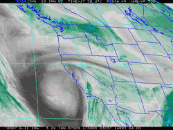
According to the NWS Climate Reports, Los Angeles (USC) recorded only 0.16 inch of rain on Saturday, and none on Sunday. This brings the preliminary January rainfall total to 0.17 inch – tied with January 1984 as the 10th driest on record – and the water year total (since July 1) to 1.48 inches. A water year total less than 1.72 inches on February 1 would rank this season's July-January rainfall as the 5th driest on record. BUFKIT analysis of 12z NAM/WRF and GFS, and output of the 09z SREF suggest a continuing chance of showers in the Los Angeles area through at least Wednesday. Amounts and probabilities for a particular area depend on the behavior of a capricious cut-off upper low spinning off the coast. BUFKIT data for LAX, Van Nuys and Santa Barbara generate precipitation totals ranging from as little as 0.1 inch to as much as 0.7 inch. The 09z SREF puts the probability of more than 0.1 inch of rain in the 24 hr. period ending 7:00 a.m. Wednesday at Los Angeles at about 50%, and lowers that probability to about 10% for more than 0.25 inch. We'll see! More information concerning Southern
California weather can be found using our WEATHER
LINKS page. |
|
|
Chance of Weekend Showers.
January One of the Driest on Record? So far this January Downtown Los Angeles (USC) has recorded only 0.01 inch of rain. This makes it a contender for one of the driest Januarys on record. Where it will rank depends on the amount of rain a cut-off upper low currently spinning off the California coast generates in the Los Angeles area over the next few days. And that is difficult question. |
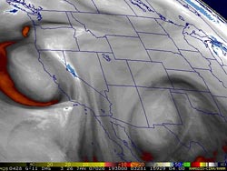
A BUFKIT analysis of 12z GFS data generates nearly 1.0 inch of rain at Santa Barbara over the weekend, while the NAM/WRF produces little more than drizzle. Neither model generates more than drizzle or very light rain at LAX. The !8z NAM/WRF seems more in line with the 12z GFS, but still has little in the way of precipitation in the Los Angeles area. The 09z SREF puts the probability of more than 0.01 inch of rain in a 24 hr. period over the weekend at Los Angeles at about 30-50%, and lowers that probability to about 10% for more than 0.1 inch. According to the NWS Climate Report for January 25, 2007, Los Angeles (USC) has recorded only 1.32 inches of rain since the water year began on July 1. This is 5.06 inches below normal for the date. Looking back through NWS data, Downtown Los Angeles has recorded only 1.32 inches since May 22, 2006 -- a period of more than 8 months! As of today, the water year rainfall total is less than in the record setting dry water year of 2001-2002. Both the 6-10 day and 8-14 day outlooks from the CPC project below normal precipitation for Southern California. We'll see! Update 01/26/07 9:00 P.M. Interesting situation developing with vortex rotating around cut-off upper low and a 80 kt. jet max nosing into the coast. The 18z and 01/27/07 00z GFS are much wetter at Los Angeles than earlier runs, generating about 0.7 inch of rain beginning mid-morning Saturday. However, the same runs of the NAM/WRF remain almost dry. More information concerning Southern
California weather can be found using our WEATHER
LINKS page. |
|
|
Record Low Temperatures. Drought
Continues. Usual El Niño Impacts Still On Hold. Chance
of Showers? Many new record low temperatures for the date were set across the area early Sunday morning, including Downtown Los Angeles at 36°F, Burbank at 26°F, Long Beach at 31°F, Palmdale 10°F, and Lancaster at a frigid 3°F. Woodland Hills tied the record for the date at 20°F, as did the Santa Monica Pier at 39°F. Several new record low temperatures for the date were also set early today, mainly in areas not affected by winds. (NWS data is preliminary.) |
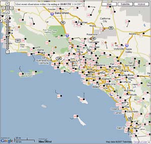
This map of 24 hour minimum temperatures as of 10:00 am Sunday is indicative of the very cold air mass. It was created using a new experimental interactive MesoWest mapping interface. According to the NWS Climate Report for January 14, 2007, Los Angeles (USC) has recorded only 1.31 inches of rain since the water year began on July 1. This is 3.81 inches below normal for the date. Looking back through NWS data, Downtown Los Angeles has recorded only 1.31 inches since May 22, 2006 -- a period of 7 months and 25 days, including today. As of today, the water year rainfall total is less than in the record setting dry water year of 2001-2002! So what about Southern California rainfall associated with the El Niño? The much anticipated change to a pattern with an energetic Pacific jet typical of an El Niño has failed to occur. Later this week a cut-off low is forecast to form west of Pt. Conception and spin just off the coast for a couple of days. Exactly where it spins, and the amount of moisture available to it, could affect whether or not there is precipitation in our area. We'll see! Update 01/18/07 3:00 P.M. Cut-off upper level low produced isolated showers, snow showers, sleet, and hail, as well as some lightning and thunder. News reports showed snow on Kanan-Dume road in the Santa Monica Mountains at an elevation of about 1500-1600 ft. Because of the convective nature of the precipitation, storm totals ranged from nothing to as much as 0.37 inch at Thousand Oaks. Downtown Los Angeles (USC) only recorded 0.01 inch, bringing the water year total to 1.32 inches, which is 4.24 inches below normal. Current model forecasts suggest that "wrap around" precipitation from the low this Friday and Saturday should mainly be confined to areas south and east of the Los Angeles basin, but (as always) that might change. Here's a photograph of a snow shower over Rocky Peak Park yesterday afternoon. Update 01/17/07 1:00 P.M. Cut-off upper level low is stirring up some rain and snow in the greater Los Angeles area. CNRFC reports 6 hr. precipitation amounts ranging from 0.01 to about 0.05 in the Los Angeles basin and surrounding valleys, to as much as 0.15 inch at Del Valle and 0.20 inch at Sandberg. CalTrans reports that I-5 is closed over the Grapevine due to snow. Cut-off low is forecast to move along the coast into northern Baja Mexico, and could generate some "wrap around" precipitation in Southern California this Friday into Saturday. More information concerning Southern
California weather can be found using our WEATHER
LINKS page. |
|
|
Wind Instead of Rain. Frigid
End of the Week? El Niño May Have Peaked. So far this rain season passing cold fronts have stirred up more wind than rain. This was the case again overnight Thursday. A weakening cold front produced little precipitation, but its passage generated winds in excess of 80 mph at the Cheeseboro RAWS near Agoura, and Whitaker Peak RAWS along the I-5 corridor south of Gorman. |
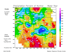
The windstorm resulted in only a trace of rain at Downtown Los Angeles (USC). According to the NWS Climate Report for January 5, 2007, Los Angeles (USC) has recorded only 1.31 inches of rain since the water year began on July 1. This is 2.92 inches below normal for the date, and more than an inch less than the total rainfall recorded at this time in the record setting dry water year of 2001-2002. This precipitation map from the WRCC for the period 10/01/06 to 12/22/06 shows just how dry it has been in the southwest. Following a period of pleasant weather, with highs in the seventies, temperatures in the Los Angeles area are forecast to drop by as much as 20 degrees by Thursday or Friday. The GFS (and ECMWF) shows a deep trough digging into the southwest, and transporting cold air into the area. The cold air, combined with low thickness values could drop temperatures to near freezing at the lower elevations overnight Thursday and Friday. The high desert and mountain areas could see very cold temps. At the moment, there isn't much moisture associated with this system, but some showers or snow showers appear possible in the Thursday-Friday timeframe. We'll see! The quirky 2006-2007 El Niño may have peaked. Dr. Klaus Wolter's Multivariate ENSO Index (MEI) for November/December decreased from 1.293 to 0.985. This resulted in the biggest one-month drop in MEI rank on record for this time of year, and placed the MEI just below the moderate El Niño threshold. The Southern Oscillation Index (SOI) has increased to zero, the western Pacific warm pool has cooled, and SSTs on the surface and at depth in the vicinity of the date line have also cooled, suggesting a further drop in the MEI is probable. So what about Southern California rainfall associated with the El Niño? It's still possible. For several days the GFS, NCEP ensembles, and other guidance have been hinting at a late January breakthrough of the westerlies, perhaps resulting in a flow pattern that is typically associated with an El Niño. We'll have to see if that pattern actually develops. Update 01/10/07 4:00 P.M. Today's 18z NAM and GFS are now projecting from about 0.1 inch to 0.25 inch of precipitation from the system Thursday and Friday. There is the possibility of snow showers down to the foothill level. Update 01/07/07 9:00 P.M. Strong winds continue to be the story. This morning the Chilao RAWS recorded a wind gust of 85 mph and sustained winds of over 50 mph. This afternoon the Malibu Hills RAWS recorded a gust of 73 mph and much of the day had sustained winds of 35-40 mph. Downtown Los Angeles (USC) wasn't nearly as windy and recorded a pleasant high of 76 degrees. Recent runs of the GFS continue to show a cold, moisture starved inside slider for the end of the week, with more wind for the weekend. It looks like it may be a while before we see significant rain. Los Angeles has had only 1.31 inch of rain in the last 230 days. (Since 0.67 inch was recorded on May 22, 2006.) More information concerning Southern
California weather can be found using our WEATHER
LINKS page. |
|
or Press your Browser's BACK button.