|
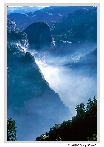
YOSEMITE Smoke highlights the prominent southwest buttress of Grizzly Peak, which rises more than 2000 ft. from the Merced River, upstream of Happy Isles in the Yosemite Valley. Liberty Cap looms in morning shadow beyond. More... |
|
YOSEMITE Smoke highlights the prominent southwest buttress of Grizzly Peak, which rises more than 2000 ft. from the Merced River, upstream of Happy Isles in the Yosemite Valley. Liberty Cap looms in morning shadow beyond. More... |
 |
Smoke highlights the prominent southwest buttress of Grizzly Peak, which rises more than 2000 ft. from the Merced River, upstream of Happy Isles in the Yosemite Valley. Liberty Cap looms in morning shadow beyond. |
Low on this buttress is Sierra Point, which the more adventurous can access using a long abandoned, overgrown, intermittent path. In his Handbook of Yosemite National Park (1921), Raymond H. Bailey wrote:
Experienced climbers looking for a adventurous mix of scrambling, climbing and bushwhacking can continue up the Southwest Arete of Grizzly Peak above Sierra Point to the summit of Grizzly Peak (6222 ft.). Listed as 4th class in Roper's 1970's Climber's Guide to Yosemite Valley, the route has been described as moderate 5th class in trip reports by George Sinclair and Bob Burd. |
|