|
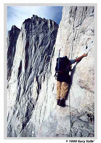
THE SIERRA The spectacular east face of Keeler Needle (14,240 ft) dominates the view as Greg Bender checks out the 1000 ft. of exposure below the Tower Traverse, on Mt. Whitney's popular East Face route. More... |
|
THE SIERRA The spectacular east face of Keeler Needle (14,240 ft) dominates the view as Greg Bender checks out the 1000 ft. of exposure below the Tower Traverse, on Mt. Whitney's popular East Face route. More... |
 |
The spectacular east face of Keeler Needle (14,240 ft) dominates the view as Greg Bender checks out the 1000 ft. of exposure below the Tower Traverse, on Mt. Whitney's popular East Face route. |
|
The Tower Traverse follows the sloping ledge just above Greg. Psychologically this traverse may be the crux of the climb. The moves across the traverse are not difficult, but rounded footholds, stupendous exposure, meager handholds, and less than ideal protection demand the climber remain focused. In contrast, the wonderfully exposed Fresh Air Traverse has a large hold and good protection at its crux move. (Assuming the large flake/block stays in place!) Because so much attention is given to the spectacular Tower and Fresh Air Traverses, the difficulty of a drab squeeze chimney at the top of the Grand Staircase is often overlooked. This inglorious feature may be the technical crux of the climb. The chimney is short, and begins and ends on relatively easy ground, or it would surely be more infamous. The ice axe Greg is carrying is for possible use on the descent of the Mountaineer's Route. On the descent we found a surprising amount of ice on the rocks at the point where the Mountaineer's Route meets the summit ridge. (This juncture can be seen in the black and white photograph The Whitney Group in the Split Rock Gallery.) Examining several alternatives, we found a way to thread our way down through the steep rock and ice at the crest of the ridge. Continuing down the rock rib we bypassed the icy snow on the upper part of the couloir. Eventually the angle lessened and the snow became softer, and we moved onto the snow and continued down to our camp. The snow was not terribly steep, but it was nice to have the ice axe along. Though it is "normally" climbed on a two or three day outing, Mt. Whitney is a frequent target of "one day" ascents from Whitney Portal, either by the trail, or one of the east face routes. Beyond the obvious physical challenge of a 6600 foot elevation gain and loss over approximately 20 miles, such an ascent requires accurate and well reasoned decisions. An error in judgment on a two day ascent may slow you down, but on a one day ascent it could result in a very cold night out! One of my most memorable ascents of Whitney was a one day ascent of the East Face done with Phil Warrender. Starting at the Portal we took four hours to reach Iceberg Lake, four hours to do the East Face route, and four hours to return to the Portal via the trail. This was not a breakneck rate. We paced ourselves going up Boy Scout canyon, roped up on key sections of the East Face, and spent some time enjoying the summit. We did run some on the descent, but the long day and miles and miles of rocky downhill trail took their toll. Enthusiastic running strides taken on the switchbacks of Trail Crest became mere anguished shuffles by the time we limped into Whitney Portal! If you are fit, healthy, and trained for the challenge, it can be fun to do a peak with an emphasis on speed. To do a peak fast requires a collaboration of skills and intent. There's a freedom of motion and an intimacy of terrain and environment that is associated with focused effort. Just how fast is it possible to do Mt. Whitney round trip? According to the China Lake Mountain Rescue Group's Talus Pile December 2002, Issue # 126, Jason Lakey did the roundtrip via the Mountaineer's Route in a record 3 hours, 10 minutes and 7 seconds. His time to the top was 2 hours, 9 minutes, and 30 seconds, about a minute over the ascents of Sid Hayes via the trail and Marty Hornick via the Mountaineer's Route. A good starting point for information about climbing Mt. Whitney is the book Climbing Mt. Whitney by Wynne Benti and Walt Wheelock. This book is a substantially revised and updated version of the venerable purple book we've seen on the bookshelf for so many years. Additional information about climbing routes on the peak can be found in R.J. Secor's The High Sierra, Peaks, Passes and Trails. |
|