 |
THE SIERRA Gorge of Despair, Cobra Turret |
| |
THE SIERRA Gorge of Despair, Cobra Turret |
|
The "despair" in the place-name "Gorge of Despair" could only refer to the arduous nature of the hike required to get there and, perhaps, the impossibility of getting to the Middle Fork of the Kings River from the Gorge. More... |
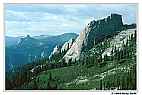 |
The "despair" in the place-name "Gorge of Despair" could only refer to the arduous nature of the hike required to get there and, perhaps, the impossibility of getting to the Middle Fork of the Kings River from the Gorge. |
|
Situated some 3500 vertical feet above the Middle Fork in Kings Canyon National Park, the journey to the Gorge includes long, steep trails and rigorous cross-country travel. Nearly 7000 feet of elevation gain is rewarded with a difficult 2500 foot descent, threading between steep granite slabs, and stands of avalanched aspen. Once in the Gorge, 3000 foot cliffs bar access to the Middle Fork canyon. This view is of the crags on the northeastern rim of the Gorge and extends across the Middle Fork of the Kings River to Kettle Dome. The large formation in the foreground is Cobra Turret, with El Comandante and El Corporale Turrets beyond. Beyond the formations in this photograph, and just on the brink of the stomach wrenching drop into the Middle Fork canyon, is Fascination Turret. Standing on the summit of Fascination it is easy to understand the inspiration for its name. Remote and wild, its north face drops nearly 3000 feet to the rapids and rattlesnakes of the Kings River. Granite walls and peaks of all shapes and proportions fill the view. Across the deep canyon and appearing nearly close enough to touch is Tehipite Dome, a massive dome often described as the largest in the Sierra. Phil Warrender and I have done quite a bit of climbing in the Gorge, sometimes climbing established routes and at other times doing new routes. Some of the most exhilarating routes have been on Cobra, including the prominent prow of the formation in 1979, and a 1992 route that follows (more or less) the border of the shadow on the face toward the camera. The Prow of Cobra route was actually started in 1973, but bad weather, rope and shoe eating animals, and other maladies delayed its completion until 1979. The black and white photograph Silver Spur (in the Split Rock gallery) was taken from a position near Cobra and almost precisely opposite the camera position for this photograph. |
|
