|
|
Yucca CreekApproximately 1.5 miles to confluence with N.F. Kaweah River |
|
|
Yucca CreekApproximately 1.5 miles to confluence with N.F. Kaweah River |
| SUMMARY | |
| Location: |
North of Three Rivers, California |
| Put-in: |
Approximately 1.5 miles upstream of confluence with N.F. Kaweah River (2200'). This is a very rough guess. The best landmark for the put-in is the drop we called Sig Alert. Some scrambling on a rock apron is required to get to the top of this drop. |
| Gradients: |
Average: About 300 fpm |
| Take-out: |
Confluence with the N.F. Kaweah (1755'). |
| NOTES | |
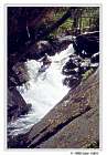 Sig Alert |
We were intending to do the upper section of the N.F. Kaweah, but due to some logistical problems arrived too late at the regular N.F. put-in to do the required seven mile hike. Yucca Creek was also on our "A" list, so the decision was made to see how far up the creek we could get, and maybe salvage part of the day. Sometimes things just work out. The initial half-mile of the hike was idyllic, passing through beautiful green meadows, highlighted with wildflowers. However, the old trail gradually became more and more overgrown, eventually degrading into thick chaparral, interwoven with poison oak. |
|
The ravaged, remnants of a ringtail cat should have been a warning. It looked like the trail might continue on the river right side of the creek. Following a path over a rocky steep and across a south facing slope, we soon found ourselves committed to a dangerously steep and loose slope. Stubbornly, we pushed onward, hauling our boats up with a throw rope, and then lowering them down into rocky ravine. From here we were certain we could work our way back to the creek. Wrong. Our descent was blocked by a slimey 15 ft. waterfall. Digging a sling out of my pack, we fashioned an anchor and rapped over the step. Once this was accomplished, we crossed to the river left side of the creek, picked up the overgrown trail, and continued upstream. It was getting late, and there was boating to be done. Around 3:00 p.m. we reached the pool below Sig Alert. It was obvious this was as far as we would go on this day. We put on at around 3:15 and reached the take-out shortly after 7:00 p.m., having completed one of the best short runs we've done to date. On a later trip we had more time and hiked further up the creek. Treking above Sig Alert was a real adventure. At times the brush was so thick that there the best (and only) choice was to walk through head high thickets of poison oak. Tedious and time consuming bushwhacking resulted in diminishing returns--very few drops above Sig Alert were as good as those downstream of this rapid. This short run has an amazing number of interesting drops. We couldn't help but to name some of the them:
Related information: |
|