 |
El Niño Madness,
|
|
El Niño Madness,
|
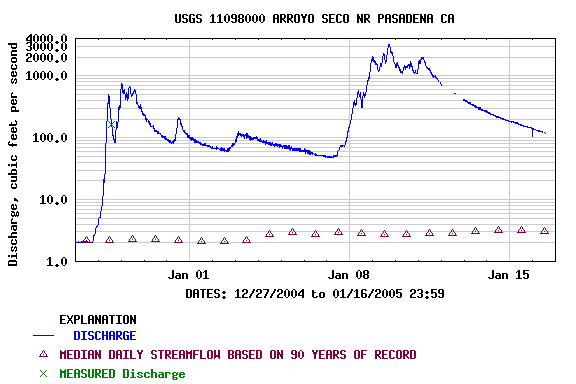
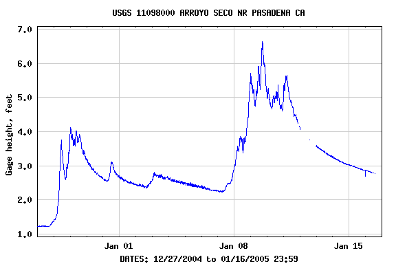
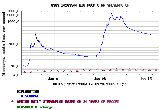
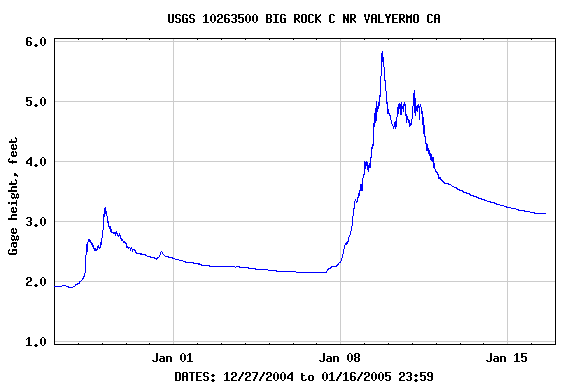
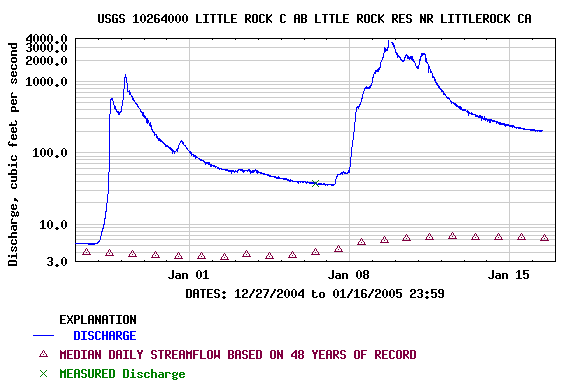
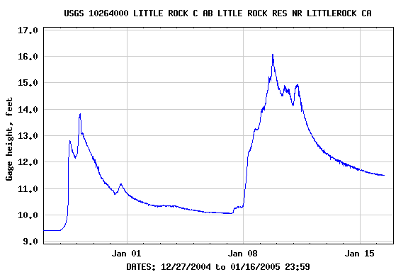
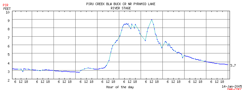
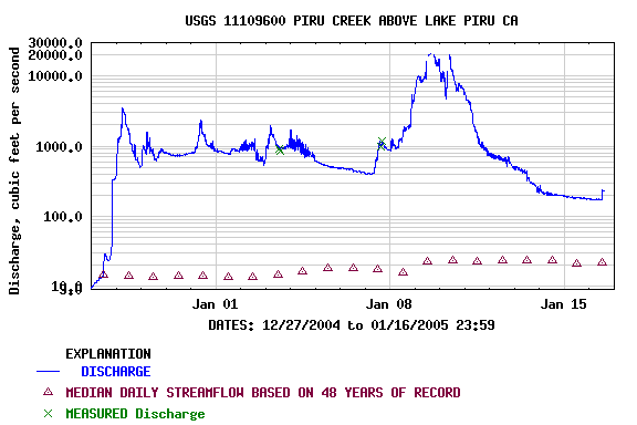
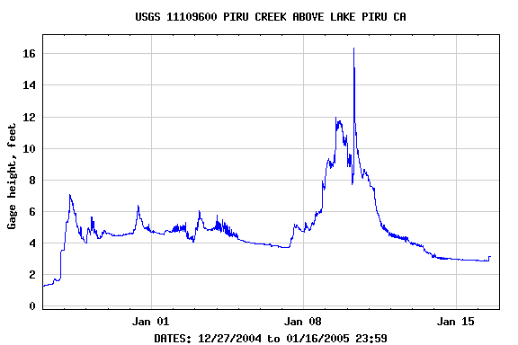
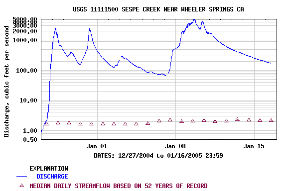
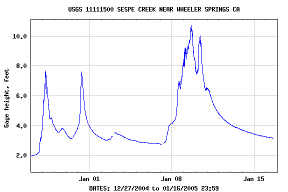
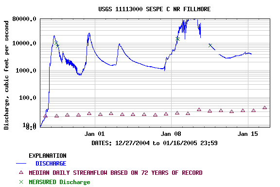
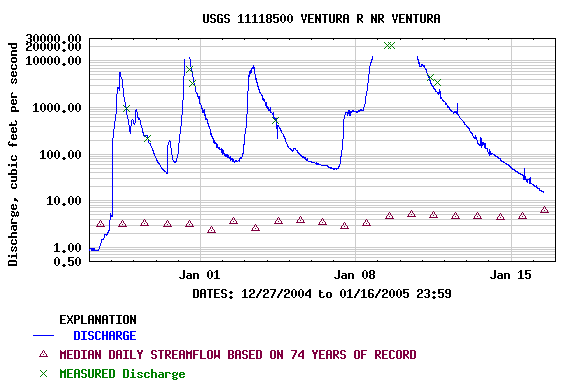
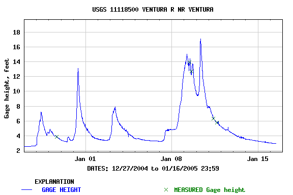
From the afternoon of Friday, January 7, 2005 to the afternoon of Tuesday, January 11, 2005, Southern California was hammered by a series of Pacific storms. A surface low west of California and associated upper level shortwave plowed into the state on Friday to start things off. Then a large northern stream upper low worked down the west coast, set up shop off the Oregon coast, and propelled southern stream moisture, jet energy, embedded shortwaves and dynamics into Southern California from late Friday into Monday. Some additional rain was recorded on Tuesday, as the upper low moved down the spine of the Sierra into Nevada. OPIDS Camp, near Mt. Wilson, recorded an astounding 31.61 inches for the 5 day series of storms. According to a NWS Public Information Statement, the 15 days from December 27, 2004 through January 10, 2005 were the wettest 15 consecutive days in downtown Los Angeles since record keeping began in 1877. This surpassed the record set in January of 1969. As of January 11, the water year total rainfall to date, since July 1, was the second highest on record, and was about 475% of normal. The following links to archived copies of NWS Public Information Statements include additional information and rainfall totals for the storm(s) from around the area. The NWS Los Angeles/Oxnard has produced an Event Summary, 7-11 January 2005 Heavy Rain and Flooding (PDF); and the California Nevada River Forecast Center has written a detailed report on the January 7-11, 2005 Southern California Heavy Rainfall Event (HTML). Streams in the area approached, and in some cases exceeded, peak flows recorded in the major rain event years of 1938, 1969, 1978, 1983, and 1998. In the 5:00 PM hour of January 9th, the LATS river gage on the Los Angeles River above Wardlow St. recorded a peak flow of 76,016 cubic feet of water per second (cfs) -- or more than a half-million gallons per second going past the gage! That same afternoon at 2:15, the USGS gage on Sespe Creek near Fillmore recorded a stage level of 16.81 feet and (uncorrected) flow of 72,600 cfs; and continued to rise to a peak of 19.0 ft. at 4:15 PM. Paddlers looking for boating opportunities had a tough time getting anywhere. Canyon and mountain roads used to access streams were closed by washouts, mudslides, rockfall and debris flows. As of January 17, 2005 many of these roads remain closed. Following are some links that can be used to check on road closures.
Unusually high water can have both positive and negative effects on a stream. High flows can flush out some problems, but can also move very large objects and debris and create new problems. Man-made structures and objects can be damaged or washed away and entangled in debris. Jams of wood and debris can create hazards or entirely block a stream channel. Undermining of stream banks can result in tree falls, slope failures and other problems. Given the number of mud and rock slides on canyon roads, many Southern California creeks may have experienced similar slides from adjoining canyon walls. These slides can continue to occur well after the rain stops. Following are the flows and stages recorded by gages on several local streams, with links to the gages. (Click on images for larger image.) |