|
|
 |
Sisquoc RiverHeath Camp to Tepusquet Rd. |
|
|
|
Sisquoc RiverHeath Camp to Tepusquet Rd. |
| SUMMARY | |
| Location: |
San Rafael Wilderness, a part of the Los Padres National Forest, east of Santa Maria, California. The Sisquoc has been designated a Wild and Scenic River. |
| Put-in: |
Heath Camp (3400 ft.), near the confluence of the Sisquoc River and Judell Creek. To get to the put-in requires a hike of at least 10 miles, with and an elevation gain and loss of about 1800 ft. From the locked gate in the SHUTTLE description, a five mile hike up Big Pine Road leads to Santa Barbara Potrero. At this point Big Pine Road heads south and Sierra Madre Road west around a promontory to the Judell Creek trailhead. There is a register at the trailhead. From here it is about 5 miles down to Heath Camp. |
| Gradients: |
1) 200 2) 160 3) 160 4)
120 5) 120 |
| Take-out: |
Tepesquet Rd. near the town of Sisquoc (450') |
| Time: |
We paddled 14 miles the first day, putting on at 8:45 a.m. on February 28 and stopping to camp at 4:45 p.m. The second day we put on at 10:00 am and got to the takeout just before 5:00 p.m., paddling about 33 miles. A slower pace would allow more time for picture taking and exploring riverside attractions. Sisquoc Falls is striking, and the historic Manzana Schoolhouse is definitely worth a stop. |
| Shuttle: |
From the river left bank of the takeout at Tepusquet Road return to Foxen Canyon Road and turn right (northwest) toward the town of Sisquoc. From Sisquoc take state highway 176, just past the community of Garey, to Santa Maria Mesa Rd. Turn back right and follow this road across the river (potential takeout) and then southeast to Tepusquet Canyon Road. This narrow, winding road eventually leads to highway 166, and bypasses the section of the highway that was washed out by the Cuyama River. Highway 166 has been repaired but the Tepusquet Rd. shuttle may still be the shortest route. We followed highway 166 east past New Cuyama and Cuyama to Kirschenmann Rd. This ends at Foothill Rd., which eventually leads to Santa Barbara Canyon Road. In this stretch a stream is crossed via an “Arizona” crossing. There may be other routes from 166 and 33. Follow Santa Barbara Canyon Road up canyon until the road forks near Santa Barbara Ranch. The left fork leads to the ranch, the right fork to the trailhead. There is a gate at this point, but on our trips it has not been locked. Beyond here the road crosses another “Arizona” crossing and several washouts, and after about three miles, a locked gate is encountered. We needed 4WD and a shovel to get to the locked gate. We were fortunate to have the help of good friend Tom Oetzell, who hiked to the put-in with us, and then saved us several hours by driving my car home. Washouts and rockfall on the approach road could cause problems recovering the shuttle vehicle. |
| Difficulty/Flow: |
The creeky first couple miles of the run were generally strenuous class IV to perhaps IV+. At our flow there was no class V. It took us about 1.5 hours to do the first mile, and then about 2 hours to do the next three. Much of the run below the South Fork was class II-III, with an occasional class III+ or IV move. Please do not be misled by the moderate rating. If this run were a climb, it would likely have an “r” rating, because of the above average risk factor. The flow was perhaps 75-100 cfs at the put-in, and 100-125 cfs or so below Judell Creek. Approximately 750-800 at the takeout. Virtually every side gully and creek added water to the river. The South Fork and Manzana Creek added significant amounts. The USGS gage 11138500 “Sisquoc River near Sisquoc” was reading between 3.8 and 3.9 as we passed, but we were cautioned that this gage may not be accurate because of the near record flows a few days before. |
| Hazards/Portages: |
This river demands as much caution as any wilderness river. The fast current, blind corners, logs, flood debris, alders and willows require vigilant boat and shore scouting, careful teamwork, and competent boat handling. Although there was only one portage most boaters would consider mandatory, there were additional spots that were potentially hazardous without a carry. We stepped around one nasty log, and avoided potential problems in a few other places by boating down secondary slots or channels. At higher flows there would likely be many more carries. This river has multiple channels on many sections, particularly in the last 35 miles, so there was much of the river we didn’t see. |
| NOTES | |
|
Gary Gunder and I first started looking at the Sisquoc in water year 94-95 after running several Southern California streams. We both had done hikes in the San Rafael Wilderness in previous years, and had been impressed by its unique wilderness character and beauty. We queried veteran boaters and other sources and discovered that it was likely the wilderness stretch of the Sisquoc River had not been paddled. (An attempt was made to descend the Sisquoc from the South Fork in the eighties, but the attempt was aborted when the raft was punctured, shortly after the put-in.) Water year 95-96 wasn't good for creeking in Southern Cal, but in February of 1997, we did Manzana Creek down to the Sisquoc confluence. We checked out the character of the Sisquoc, toured the Manzana Schoolhouse, and then had to hike the 9 miles back to the put-in. Unfortunately, that Spring would turn out to be one of the driest on record in Southern California. We would not get an opportunity to do the Sisquoc. Then along came El Nino of 1997-98, and the prospects of being able to do the run looked promising. Gary scouted the Heath Camp put-in over Christmas and we were set. We just needed a decent combination of water and weather. On February 19, 1998 we carried our boats to the Judell Creek trailhead, but snow and bad weather resulted in an abort. Just as well. Three days later heavy rain and snowmelt pushed the nearby Cuyama River to record high levels. The river washed out the shuttle road, highway 166, tragically killing three people. While waiting for things to calm down, we located an alternate shuttle route. The following weekend, February 28 and March 1, we were finally able to do the run. The river can basically be divided into four sections: A steep creek section, a somewhat pushier section dominated by hydraulic features, a fast, constant gradient section, and a floodplain section. The first six miles were by far the most physical, especially with a boat loaded with four days of food and gear. (We didn't know how long the run would take.) All sections had their share of surprises and hazards. All of it was exceptionally scenic. |
|
|
Related information: |
| HIGHLIGHTS | |
|
(To enlarge an image, click on it. ) |
|
 |
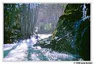
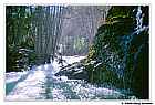
Switchbacking down to Judell Creek. The trail crossed Judell Creek several times. There was enough water in the creek that crossings were tedious; requiring that our kayaks be taken off and then put back on repeatedly. We could picture one of us falling in the swift water, and being swept downstream still attached to the boat with arms and legs flailing like some kind of giant upside-down insect. |
 |
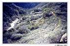
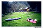
Near the put-in at Heath Camp. |
 |
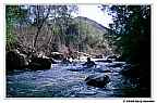
Located in California's San Rafael Wilderness, the Sisquoc River has been designated one of the nation's Wild and Scenic Rivers. |
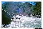 |
The river near the confluence of Rattlesnake Creek was particularly stunning. From upstream, the section looked like it might be very difficult. The warped layers of sedimentary rock resulted in some unique rapids. |
 |
Manzana Schoolhouse. A must see landmark at the confluence of Manzana Creek and the Sisquoc River. |
Click Here for All Available Images |
|