|
|
Mill CreekHidden Springs Picnic area to confluence with Big Tujunga Creek |
|
|
Mill CreekHidden Springs Picnic area to confluence with Big Tujunga Creek |
| SUMMARY | |
| Location: |
Angeles National Forest, north of Los Angeles, California |
| Put-in: |
Hidden Springs Picnic area on Angeles Forest Highway (3062'). |
| Gradients: |
1) 375 |
| End of Reach: |
Confluence with Big Tujunga Creek (2685'). |
| Take-out: |
Gaging station downstream of Angeles Forest Hwy. bridge (2640'). Parking area is 0.3 mi before bridge on Angeles Forest Hwy |
| NOTES | |
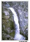 Mill Creek Falls |
Put on at 9:50 a.m. and finished about 3.5 hours later. Had one dicey portage around 40-50 foot Mill Creek Falls. There was also two or three minor portages around debris and logs. What is true of most of the steep creeks in the San Gabriel Mountains is especially true of this creek. If you run this creek, the first time down, do it with just enough water to boat it. The carry around Mill Creek Falls was not trivial. It may not always be passable, especially if there has been a lot of rain and the soil is saturated. It looked like it would be difficult to return upstream or to hike out some other way. |
|
Related information:
|
|
| PICTURES | |
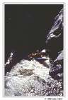 Chasm |
One of several large drops on Mill Creek. |