|
|
Arroyo SecoBear Creek Trail crossing to JPL |
|
|
Arroyo SecoBear Creek Trail crossing to JPL |
| SUMMARY | |
| Location: |
Angeles National Forest, north of Los Angeles, California |
| Put-in: |
Bear Creek Trail crossing (2753’). This is a short distance down from Switzer Falls. |
| Gradients: |
0.5) 330 Bear Cyn. 1.5) 220 2.5) 200 3.5) 180 Trail comes back to creek 4.5) 200 Oakwilde Picnic Area (Escape goat trail to Hwy 2.) 5.5) 100 Debris Dam (Caution!) 6.5) 160 7.5 140 Gaging Station. Trail to Hwy 2. 8.5 120 9.5) 160 Take-out JPL parking lot Average: 170 fpm |
| Take-out: |
Bridge and JPL parking lots (1140’). |
| NOTES |
|
Persistent upper low provided enough precipitation to finish Arroyo Seco. The USGS Arroyo Seco gage ranged from about 2.75 down to 2.5. Was ideal flow for combination of big drops and “read and run” sections. A little more would have been OK. We had pre-scouted Royal Falls and other key sections of the run, and finished the reach around sunset. |
|
This is the third of three segments we paddled on Arroyo Seco. The other two are:
Related information: |
| PHOTOS | ||
© 1996-2023 by Gary Valle' and Gary Gunder |
||
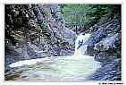 |
Gary Valle running Royal Falls in Royal Gorge on Arroyo Seco. |
|
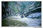 |
Section of Arroyo Seco below Royal Falls and upstream of Long Canyon. |
|
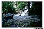 |
Cascade near point where Gabrielino Trail returns to the creek. | |
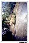 |
Rappeling the debris dam on Arroyo Seco. | |
