| |
The
Topanga Fire, Part I: Rain, Wind and Fire.
Wednesday,
March 29, 2006
Updated May 5, 2011 (Before/After Photos)
Copyright © 2011 Gary Valle'. All Rights Reserved. |
 
Smoldering remains of thick chaparral
October 12, 2005 (T+14)
|
Note: The "T
numbers" specified are relative to the start of the
Topanga Fire on Wednesday, September 28, 2005 (T+0). The
active spread of the fire ended the afternoon of Friday,
September 30 (T+2).
Nearly
two weeks after the Topanga wildfire burned 24,000
acres of ecologically diverse Mediterranean habitat northwest
of Los Angeles, the charred
remains of thick chaparral continued
to smolder. Around me black fingers
of Yerba Santa, Ceonothus and Chokecherry projected from the
barren earth, their skeletal remains reflecting the fury of
the fire.
Running through
the stark landscape, it was hard to accept that fire is
a much a part of the environment as the wind and the rain. |
Southern California's
annual cycle of rain, drought and wind promotes periodic fire.
Winter rainfall is extremely variable, and Summers are hot
and dry. The average annual rainfall in downtown Los Angeles
is about 15 inches, but it is an average of extremes. Year
to year rain totals can differ by more than 10 inches, and
it is common for the area to have less than an inch of rain
from May to October. In the Fall, our low elevation basin
geography combines with post-frontal high pressure in the
Great Basin to produce multi-day periods of strong, compressionally
heated "Santa
Ana" winds. |
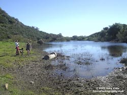
Vernal Pond at China Flats
January 30, 2005
|
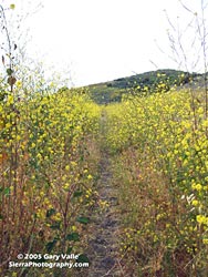
Black Mustard at Ahmanson Ranch
April 26, 2005
|
The rain season
of 2004-2005 was the second wettest on record for Los Angeles.
From July 1 to June 30, a total of 37.25 inches of rain was
recorded — more than twice the normal amount. Spring
growth was phenomenal. Large areas of Ahmanson Ranch were
blanketed with black
mustard several feet tall.
In some areas of Las Virgenes Canyon milk
thistle (Silybum
marianum) towered
above the heads of hikers and runners like Klingon corn.
Desiccated by months of heat and drought, these, and other
rain enhanced understory materials, would burn with frightening
ease. |
The Topanga
Fire was reported to Los Angeles County Fire at 1:50 P.M.
on September 28, 2005, near the 118 Freeway and Topanga Canyon
Rd. Wind driven, the fire spread rapidly to the southwest,
running seven miles in seven hours. Erratic and extreme
fire behavior was reported on the 29th (T+1), as the fire
expanded from approximately 4300 acres to 20,650 acres. Unstable
fire behavior continued on the 30th, as the fire transitioned
to a topography driven fire. Spread of the fire essentially
ended October 1 (T+3) at 24,175 acres, and full containment
was reported at 6:00 P.M. on October 4 (T+6).
Three homes, three commercial buildings, various
outbuildings, and other improvements were reported lost. Through
the efforts of firefighters, the value of property saved through
fire suppression was estimated at $804,250,000. Property saved
due to vegetation modification, defensible space clearance,
and fire resistant construction was estimated at several billion
dollars. |
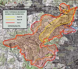
2005 Topanga Incident Fire Progression
|
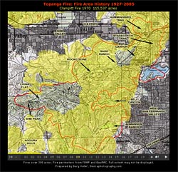
CDF-FRAP fire perimeter data lists 23 fires
over 300 acres that have burned portions of the Topanga Fire
area since 1927. This sequence
of slides shows these fires.
(Requires Flash
Player 8.)
The northern one-third of the fire area, in the area of Santa
Susana Pass, and to the southwest, was burned by the Oat
Fire (1981), and then some sections were burned again in the Box
Canyon Pioneer (1985), Hummingbird (1985), Keuhner (1988),
Chatsworth (1993), and Simi (2003) fires.
The southern half of the fire area, including Bell Canyon,
Ahmanson Ranch, Las Virgenes, Cheeseboro and Palo Comado Canyons,
and Simi Peak, were burned in the Dayton
Canyon Fire (1982). |
Topanga Fire: Fire Area History 1927-2005
Requires Flash
Player 8.
|
According to CDF-FRAP fire perimeter data, a
large area extending along the Simi Hills from northeast of
upper Las Virgenes Canyon through Rocketdyne to Black Canyon,
had not burned since the Clampitt
Fire (1970). In addition, a discontinuous area extending
from the head of Las Virgenes Canyon west to the northern flanks
of Simi Peak had not burned since the Devonshire-Parker
Fire (1967).
These 35+ year-old stands generally
correspond to areas of very high hazard (red) mapped in this
graphic of CDF
Fuel Rankings.
My own "on the ground" impressions of burn severity
roughly paralleled these fuel rankings as well. |
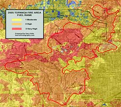
Topanga Fire Area: CDF Fuel Ranks
|
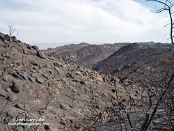
Barren slopes north of Simi Peak
October 16, 2005 (T+18)
|
In an area
north of Simi Peak, the fire intensity was such that nearly all
plant materials were consumed down to the mineral earth.
This was also the case on slopes of similar aspect northeast
of Sage Ranch.
These before
and after views of several locations within
the fire area characterize the severity of the fire. The "after" views
were taken shortly after the fire area was reopened to the
public, and 5+ years after the fire.
The capriciousness of
fire was well illustrated in upper Palo Comado Canyon, southeast
of China Flat. Here, an island of brush remained in an area that had been severely
burned. |
Ahmanson Ranch's
Oak and Riparian Woodlands and Grassland habitats distinguish
it from the various chaparral and sage scrub habitats that
make up the majority of the fire area.
In contrast to the rapid replacement
strategy adopted by chaparral shrubs, Valley and Coast Live
Oaks deal with fire
in a simple, stoic fashion — they survive it.
This is due
in part to their thick,
convoluted bark and ability to quickly
regenerate foliage.
However, not all oaks survive.
Oaks weakened by disease or otherwise compromised may fall
victim, sometimes painting
a ghostly
image of the tree in ash. (Upper Cheeseboro and Las Virgenes
Canyons, respectively.) |
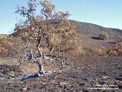 Burned Valley Oak at Ahmanson Ranch
October 13, 2005 (T+15) |
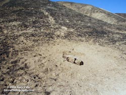
Animal Killed by the Fire, Las Virgenes Canyon
October 13, 2005 (T+15)
|
What about
the animals? Less mobile, ground dwelling animals probably
had the highest mortality. On October 1 (T+3), a friend reported "dozens
of dead animals, mostly rabbits" in an area on the eastern
margin of Ahmanson Ranch. Several days later (T+15) few carcasses
remained, and I saw only isolated instances of dead animals
on or near trails. With the exception of the carcass of a
deer, most of these were rabbits or small
rodents. The quail population may have also been significantly
impacted.
In the weeks following the fire,
I have seen several coyotes and the tracks of a few deer,
but very few ground squirrels, rabbits, or quail. |
Remarkably, within
days of the start of the Topanga Fire, and while the fire
still smoldered in some areas, this Yerba
Santa along the Hummingbird Trail was already replacing
its scorched leaves.
Less than a month after the
fire (T+27), following a drenching October rain, the muted
browns and blacks of the burned grasslands of Ahmanson Ranch
erupted in a lime-green
blanket of new growth. Shortly thereafter (T+36),
several day-old growth was observed on both Coast
Live Oaks and Valley
Oaks. Less than two months (T+48) following the fire,
crown sprouting of Yerba
Santa and Laurel
Sumac had begun
at Sage Ranch. |
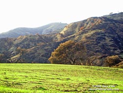
First Sprouts of Grass at Ahmanson
Ranch
October 25, 2005 (T+27)
|
Notes:
Since its acquisition by the Santa Monica Mountains Conservancy
in late 2003, Ahmanson
Ranch is referred to as the Upper
Las Virgenes Canyon Open Space Preserve.
The GIS products Global
Mapper, TatukGIS.
and Xport
Pro were used to create fire area graphics.
References for Part I:
After
Action Report Topanga Fire CA-LAC208724 28, Sept 2005 – 6,
Oct 2005 (PDF)
Fire History Perimeter data is from the Fire
and Resource Assessment Program,
California Department of Forestry and Fire Protection, Information
and Data Center, Data :
Fire
Perimeters.
Topanga Incident Perimeter data is from the Geospatial
Multi-Agency Coordination Group (GeoMAC). Perimeters are
collected in the field by a variety of means, including infrared
flights, and by using a GPS unit to map the perimeter. Please
NOTE: GeoMAC only displays perimeter data as they are submitted
by field offices. |
|